|
July 1: A Side Trip to Brasilia |
|
Return to the Brazil Trip Index |
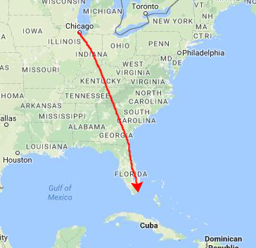
This is going to be a long trip- two weeks away from home in Chicago. And with the international travel, I was happy to have Steve Goldberg make the arrangements- not only for the trip to Rio, but also for two side trips. I was careful to get the condo all closed up, and on Saturday afternoon, I left on the first leg of my trip- the flight to Miami.
The Trip to Rio de Janeiro
|
 |
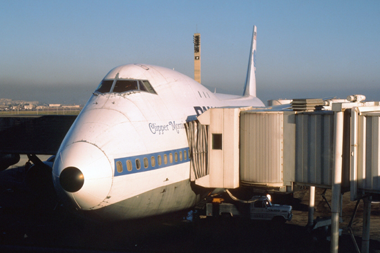
I didn't take any pictures down to Miami, nor was I able to take any on the way to Brazil, since the flight was at night. I got a nice dinner on Pan Am, and then spent the rest of the 9-hour flight.
About an hour out from Rio, the airline served breakfast, and it began to get light enough for pictures. I took two on the way into our landing at Rio's Galeăo International Airport.
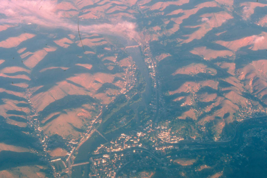 This is some of the mountainous, sparsely-populated area north of Rio in Brazil. I thought that the smoke plume from one or more fires was interesting. |
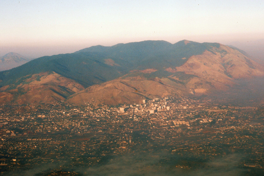 This is actually part of the city, and some of the area's mountains. As with many places I've gone outside the United States, there seems to be a good deal of air pollution. |
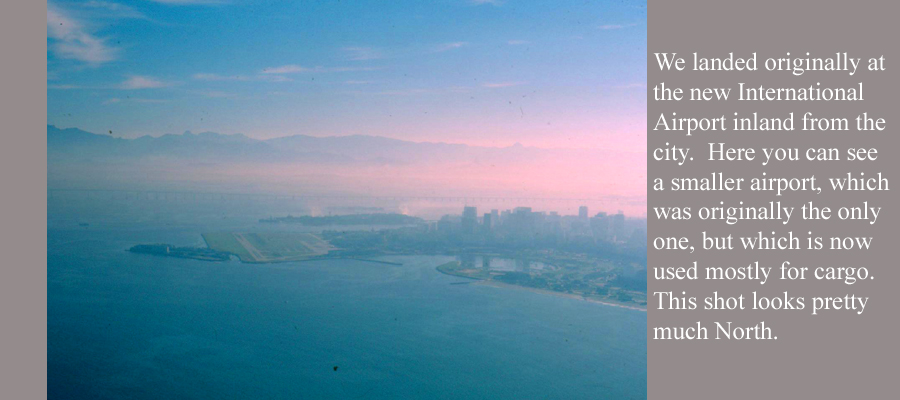
The flight landed in Rio pretty much on time, at an airport that looked as if much of it was brand new.
|
Much later in my traveling career, I was to find that this is common when visitors to the US return to their home countries. For most of them, shopping in the US is quite an experience, as there are many goods they can't get at home at reasonable prices. So, when they go to the US, they stock up. I found that many business travelers take with them requests from all their relatives for stuff to bring back, a practice that is identical to the way servicemen in Korea would ask those going to Japan on R&R to pick up various items for them.
Galeăo International Airport, the main airport serving Rio de Janeiro, is the country's second-busiest international airport. It is named after Praia do Galeăo (Galleon Beach), located in front of the original passenger terminal. The airport was, up through World War II, Galeăo Air Force Base; but after the war, the existing passenger airport, Santos Dumont, was unable to handle the increased traffic, and so international flights were moved to Galeăo. But this was only temporary, and in 1952 the new passenger terminal was opened and remained in use with enlargements until a replacement terminal was constructed in 1977.
Getting Situated at the Rio Sheraton
|
As for the city of Rio itself, I learned that is Brazil's second largest city (after Sao Paulo). The city was founded in 1565 by the Portuguese, and was originally the seat of the Captaincy of Rio de Janeiro, a domain of the Portuguese Empire. It became the capital of the State of Brazil in 1763. In an extremely rare move, the Royal Court of Portugal moved itself to Rio de Janeiro in 1808- in effect, moving the capital of a colonizing country to one of its colonies. In 1815, Brazil became part of "the United Kingdom of Portugal, Brazil, and Algarves". This situation lasted until 1822, when the War of Brazilian Independence began. Rio de Janeiro subsequently served as the capital of a republican Brazil until 1960 when the capital was transferred to Brasília.
Rio de Janeiro is one of the most visited cities in the Southern Hemisphere and is known for its natural settings, Carnival, samba, bossa nova, and beaches such as Copacabana and Ipanema. Famous landmarks include the giant statue of Christ the Redeemer atop Corcovado mountain, Sugarloaf Mountain with its cable car; and the Sambódromo, a permanent grandstand-lined parade avenue which is used during Carnival.
|
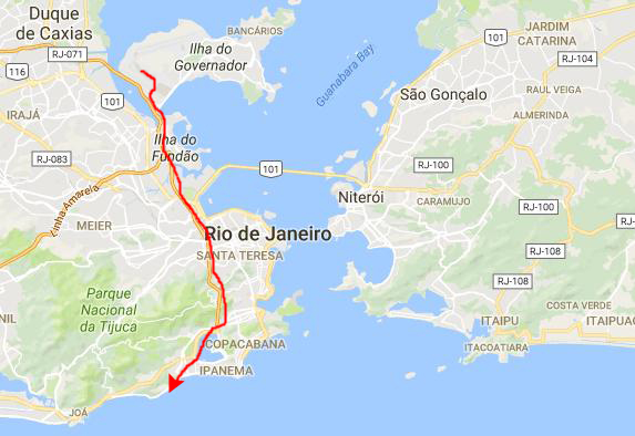
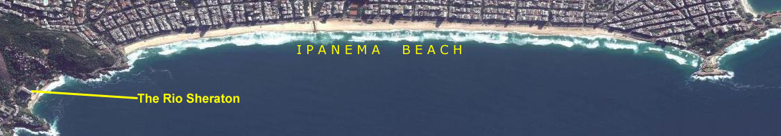
The taxi I took to the Sheraton left Governor's Island via one of the bridges connecting it to the mainland, and then headed south through an industrial area towards the city proper. I remember that there was no modern expressway into town (as there actually is today), but rather a succession of major streets. But the scenery was far from interesting (or even green) until we approached the city from the north. So the route came into town from the north, and then turned to the west to bypass the congestion of the city center- since my hotel was west of the city.
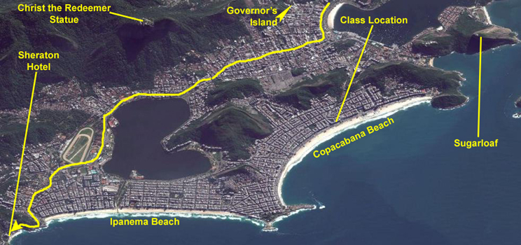
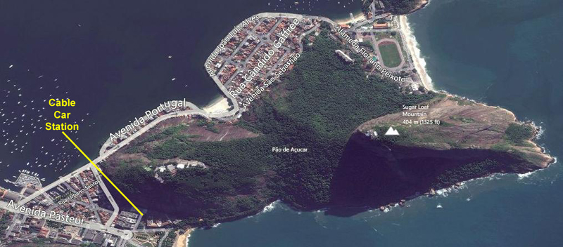
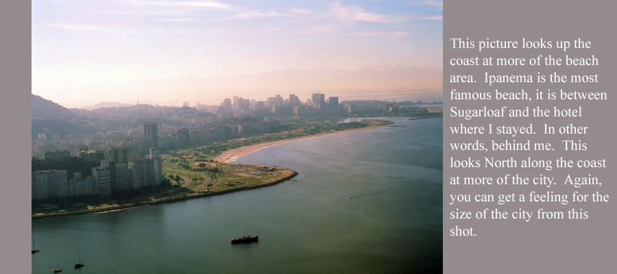
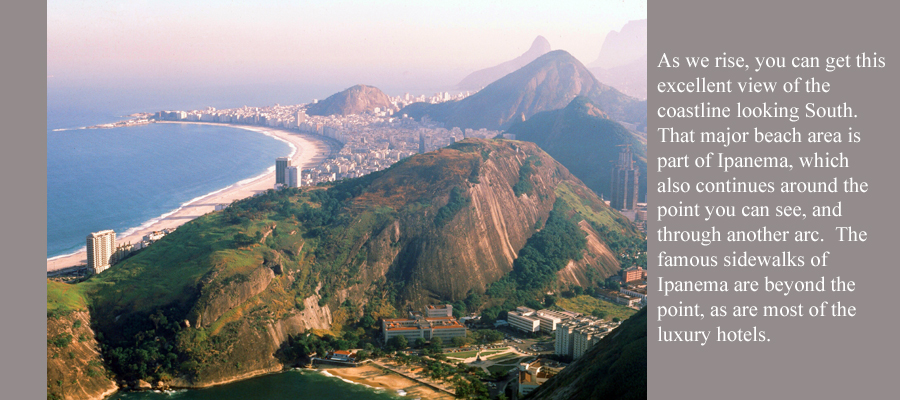
The taxi circled around the top of Freitas Lagoon and then headed south towards the west end of Ipanema Beach. When we got to the coast, the taxi took the coast road around a point of land to come to the Sheraton Hotel. I have also marked, on the aerial view, some of the major locations that I'll refer to in describing my pictures of Rio. East of the hotel, along the south coast of the city, one finds the famous Ipanema and its iconic beach ("The Girl from Ipanema"); this area is largely residential. Continuing eastward, the coast turns northeast and we come to the also-famous Copacabana area, and it's iconic beach and undulating black-and-white sidewalk. The Copacabana area is where most of the commercial buildings and downtown skyscrapers are located, and it was in a hotel along the shore road that the class will be held next week.
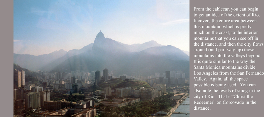
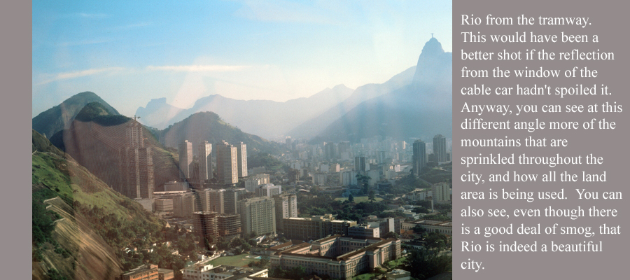
I have also marked Sugarloaf Mountain, and this page will describe my excursion over there. Finally, I have also marked the location of the famous "Christ the Redeemer" statue atop Corcovado Mountain; this statue is one of the "New Seven Wonders of the World". (Actually, most people think the statue is atop Sugarloaf, and I did too, until I did some research ahead of my trip down here.)
 |
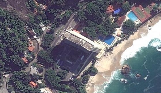
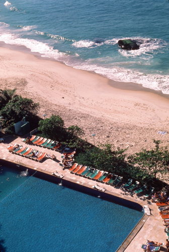
I was very pleased with the hotel that Steve found for me for my days in Rio before I moved to the Rio Palace Hotel where the class was actually held downtown. My room was quite nice, the views were spectacular, there was a big pool, and I was insulated from the bustle and noise of the city, yet within walking distance (a mile and a half or so) of it.
|
There are significant disparities between the rich and the poor in Rio de Janeiro, and different socioeconomic groups are largely segregated into different neighborhoods. Although the city clearly ranks among the world's major metropolises, large swaths of the population live in slums known as favelas. In the favelas, 95% of the population are poor, compared to 40% in the general population. There have been a number of government initiatives to counter this problem, from the removal of the population from favelas to housing projects such as Cidade de Deus to the more recent approach of improving conditions in the favelas, bringing them up to par with the rest of the city, as was the focus of the "Favela Bairro" program and deployment of neighborhood policing units.
As with most large cities, though, in 1980 there were several Rio neighborhoods with Human Development Index scores higher than the most developed countries in the world- but then the wealthy, like the poor, are everywhere.
|
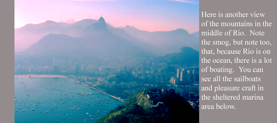
|
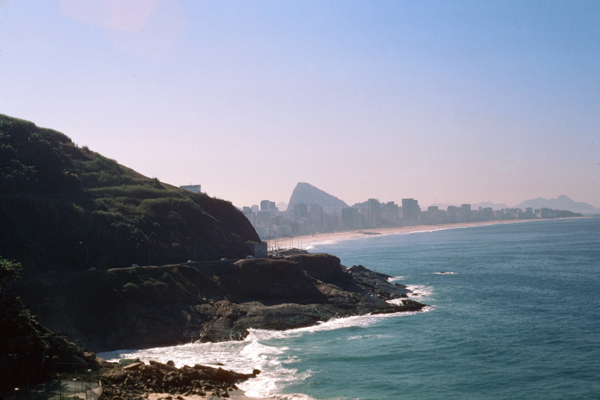
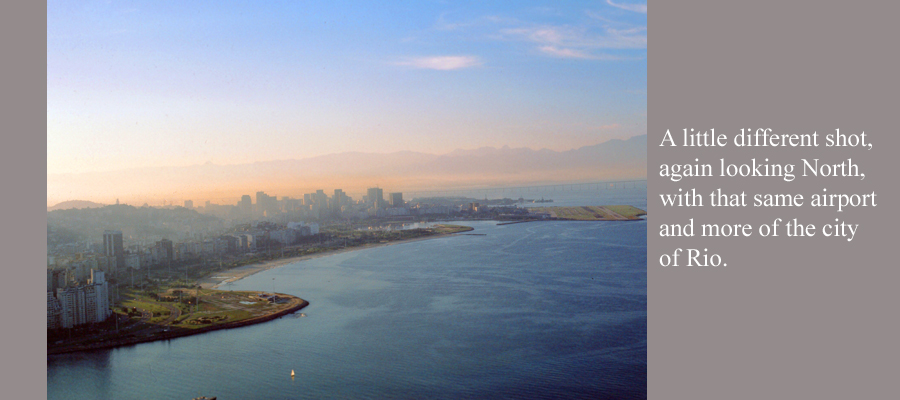
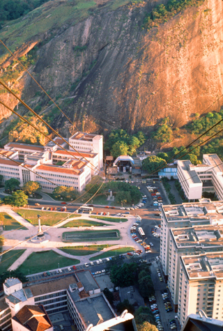
You can't really see anything of the city, since there is smog and I am miles away, but you can see the beach at Ipanema and Sugarloaf in the background. That's the Atlantic Ocean, of course, to the right in the picture, although we are looking almost directly east.
I was a bit tired from my overnight flight, particularly since I don't tend to be able to sleep on airplanes. Since the weather was warm and the day was nice, I decided to go down to the pool and get some sun. I spent the morning just relaxing at the pool. I found an American couple there, and both of them played backgammon. Since I had brought my traveling set, we spent some time playing. Later in the day, I decided to do some sightseeing, so I walked into town and around the area of Ipanema. It was getting late in the day, though, so I thought I would save any extended city excursion until tomorrow. I had some dinner at a local restaurant in Ipanema and then returned to the Sheraton.
An Excursion to the Top of Sugarloaf Mountain
|
There, I got off the bus and then walked the rest of the way (about ten blocks) to the peninsula on which Sugarloaf is located.
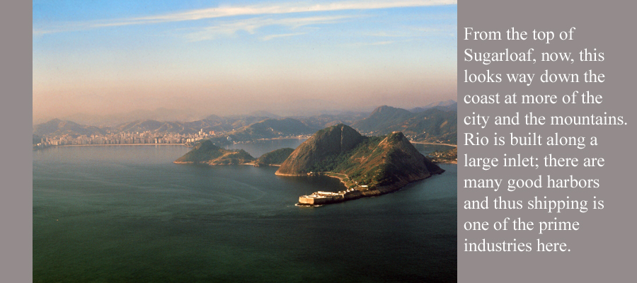
Sugarloaf Mountain is a peak situated in Rio de Janeiro, Brazil, at the mouth of Guanabara Bay on a peninsula that juts out into the Atlantic Ocean. Rising 1,300 feet above the harbor, its name is said to refer to its resemblance to the traditional shape of concentrated refined loaf sugar. It is known worldwide for its cableway and panoramic views of the city. The mountain is one of several monolithic granite and quartz mountains that rise straight from the water's edge around Rio de Janeiro that give the city much of its iconic appearance.
|
Sugarloaf is a natural landmark that is as recognizable as any man-made landmark, like the Golden Gate Bridge in San Francisco or the Empire State Building in New York City. Along with Christ the Redeemer and Copacabana Beach, Sugarloaf is one of the icons of Rio de Janeiro, meaning that most people would be able to place it here.
The desk clerk at the hotel directed me to a tramway that would take me to the top of the mountain, and he also told me all about the hours of operation and so on. He also laid out the bus route that I could follow to get across town. (I actually walked a good bit of the way and only hopped onto a bus when there wasn't much to look at.) I had plenty of time today for the trip, so I went along at a leisurely pace.
I made my way through Rio by first taking a bus towards Ipanema (there are no sidewalks on the coast road). I got off midway along the beach, and then cut through town to Copacabana, walking most of its length. Then I got a bus that was marked with the name of the area of Rio at the base of Sugarloaf; it dropped me off right at the base of the mountain.
|
|
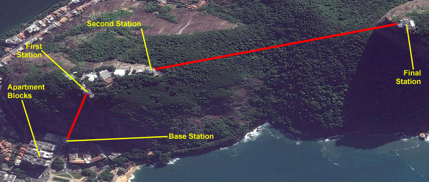
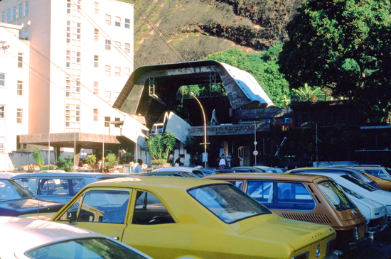
At right is the picture I took of the starting point for the tramway system that goes up the mountain. (It is hard to find this building on the aerial view. My suspicion is that it has been redone in the thirty years between when I was here and when the aerial view was likely taken. Add that to the fact that the base station was on the east side of the three apartment blocks and is thus in shadow on the aerial view.)
The tramway was not expensive, about $4 as I recall, to make the trip all the way to the top station on Sugarloaf (it seemed as if a lot of people, mostly locals I guess, only go to the first station at the top of the steepest part of the tramway). I might comment that on the whole, Rio seemed expensive to me, but then probably no more so than New York or San Francisco. It was difficult to find nice restaurants that I thought were reasonable ($5-$10 for a dinner), but part of that was probably due to the fact that, when I travel, I tend to eat at fast food places where it is hard to spend that much.
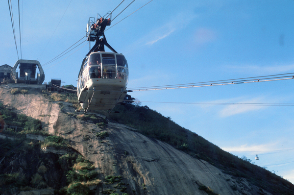 |
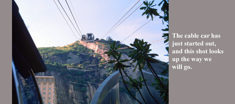
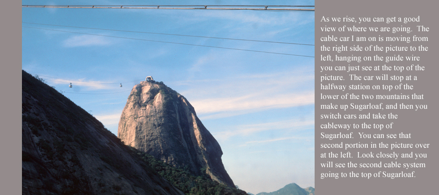
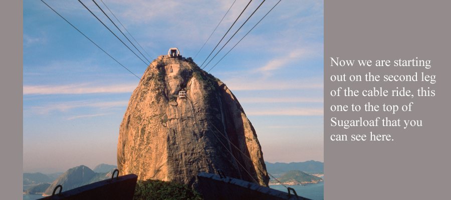
The car will stop at a halfway station on top of Morro da Urca; there, I'll walk to a different station and take a separate cableway to the top of Sugarloaf. You can see that second portion in the picture over at the left. Look closely and you will see the second cable system going to the top of Sugarloaf.
The name "Sugarloaf" was coined in the 16th century by the Portuguese during the heyday of sugar cane trade in Brazil. According to historian Vieira Fazenda, blocks of sugar were placed in conical molds made of clay to be transported on ships. The shape given by these molds was similar to the peak, hence the name.
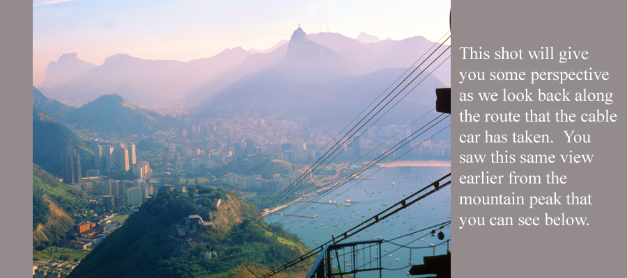
The glass-walled cable car in which I am riding is capable capable of holding 65 people, although today there seem to be only about thirty people in my car. The route between the first station on Morro da Urca and the top of Sugarloaf is almost a mile, and the cars run about every 20 minutes. The system was originally built in 1912, and was rebuilt about eight years ago. To get to Morro da Urca, you take the first, shorter cable car (on which I am riding at the moment) from the base station at the base of Morro da Babilônia, to Morro da Urca and thence to Sugarloaf's summit.
So, to reach the summit, I'll be taking two separate cable cars. The one I am on now will ascend 700 feet to the summit of Morro da Urca. Then I will walk from one station to another for the second car to the top of Păo de Açúcar. The Swiss-made bubble-shaped cars offer me 360-degree views of the surrounding city. The trip from base to summit takes about half and hour, but I'll be doing a lot of walking around as well.
|
|
To move through the slides, use the "backward" and "forward" arrows in the lower corners of each slide, and to track your progress through the slide show, refer to the index numbers in the upper left corner of each slide.
Enjoy these views of Rio de Janeiro!
Riding on the tramway was immensely interesting, but the stations both at the top of Sugarloaf and at the intermediate point atop Morro da Urca were pretty neat, too.
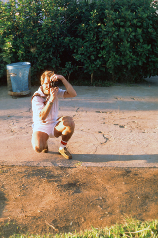 |
(Picture at left) It might challenge for you to figure out how this picture was taken. It might have been taken by another tourist using my camera, but then there would be no reason for me to borrow another one to look like I am taking a picture. It might have been taken of me by another tourist, but then how would I have got a copy of it? As it turned out, there was some sort of decorative building at the top of the mountain whose sides were polished stainless steel. It was just like a mirror, and this is actually a picture I took in that mirror. By my dress you can see that it is warm here in Rio.
(Picture at right)
|
 |
By the time I got back to the ground-level station, it was late in the afternoon, and I decided to walk back to the Sheraton (perhaps three miles).
|
As I walked back to the hotel, I followed those two arcs of beach area that you saw on the aerial view earlier. The light was beginning to fade, and most of the people had left the beach area, so I thought I should take a last picture before there was too little to do so.
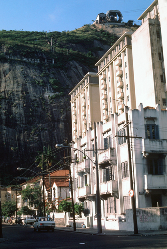
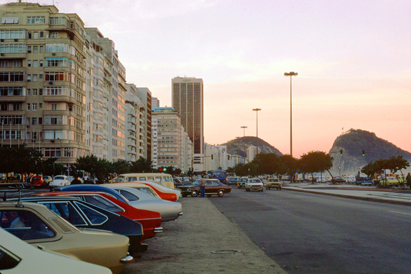
These are some of the hotels and high-class apartments that face the beach area. This arc is part of the general Ipanema area, and you can just make out that distinctive black and white walkway that you see in all the pictures of Rio. There were lots of cars in Rio, and it looks as if parking is just as much of a problem here as it is in Chicago.
I got back to the hotel just after dark, had some dinner in the hotel cafe, and then got ready to head out to Brasilia the next morning.
You can use the links below to continue to another photo album page.
|
July 1: A Side Trip to Brasilia |
|
Return to the Brazil Trip Index |