|
June 12-14, 1976: A Drive to Reno, Lake Tahoe, and Yosemite |
|
April 10-11, 1976: Exploring the Peninsula |
|
Return to Index for 1976 |
Here is another album page that wouldn't exist were I not spending so much time on our software project in San Francisco. I am very fortunate to have gotten involved in the EEO-REPORTER development, as San Francisco is such a great place to be. Not only am I enjoying staying right in the city, but every chance I get I like to go explore some nearby part of California. This weekend, I am going to spend a day in Yosemite National Park.
NOTE:
As it turned out, I made another trip to Yosemite in June of this year, and took more pictures then. I thought about combining the two trips into one page, but decided not to. I'll try not to duplicate information about the National Park on both pages, but I hope you'll overlook it if I do.
|
Eventually, I will turn off State Highway 120 onto the road that leads to one of Yosemite's entrances. This scenic highway, Big Oak Flat Road, will wind down into the Yosemite Valley and bring me to the West Portal of the National Park. The distance from San Francisco to Yosemite is about 120 miles, but not all of that is freeway, so I am estimating that the trip will take between 2 and 3 hours, so I've gotten an early start to get out of the city on my day trip to the park.
|
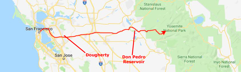
Turns out that California actually has an unincorporated community here in Alameda County called "Dougherty", located just north of Dublin (and just north of the freeway I am on), at an elevation of 348 feet. James Witt Dougherty purchased the land here in 1852, including a two-story adobe building. A community grew up around the adobe, and was first called Amador's and Amador Valley after Jose Maria Amador, the original owner of Rancho San Ramon (Amador). The post office arrived in 1860 and renamed the place Dougherty Station. The southern part of the settlement broke off and became Dublin. The post office was renamed Dougherty in 1896 and closed in 1908.
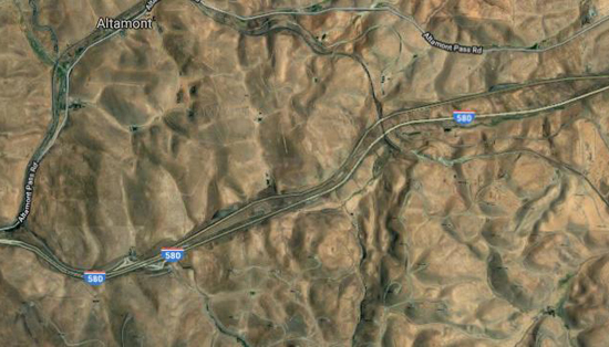
Something else interesting is that there have been big changes in this area since 1976 (not entirely unexpected). The freeway I am on is going through a fairly desolate area, and there wasn't a lot on either side of the highway. You can see that there is a simple frontage road, but not much else, and the freeway is the standard two-double-lanes-with-median, just like most rural interstates. Not so any more:
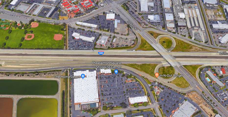 |
I used a fairly closeup aerial view here, so you could see that even the freeway has been completely reconstructed and so you could see some of the detail of all the houses and businesses that now line the roadway on either side. If I had zoomed out a bit, you would see that this development extends miles from the freeway to the north and south, and that there are four cities here now- San Ramon, Dublin, Pleasanton, and Livermore. But just a couple of miles east of Livermore, civilization runs out, and I took another picture for contrast:
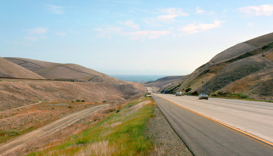 The View East of Livermore |
 An Aerial View East of Livermore |
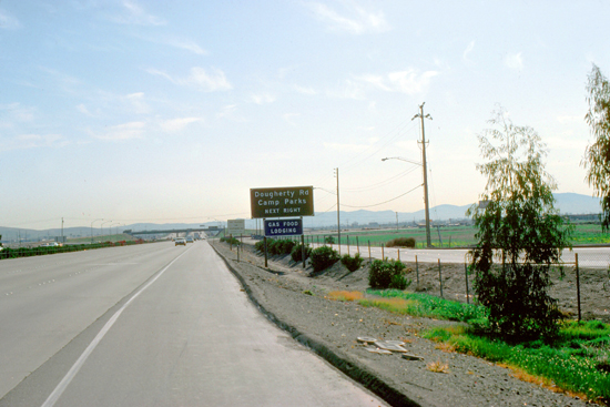
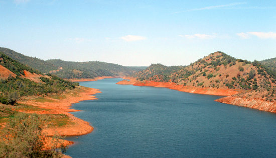
I continued on eastward, passing through Tracy and Manteca and then got on State Route 120 for the last forty miles to Yosemite. This brought me through the Red Hills Management Area, a region of 7,100 acres of public land located near the intersection of State Highways 49 and 120, just south of the historic town of Chinese Camp in Tuolumne County. The Red Hills are noticeably different from the surrounding countryside, as the soils in the area support much different flora and a rich set of small mammals and birds. Adjacent to the area is the Don Pedro Reservoir, a very pretty area:
|
|
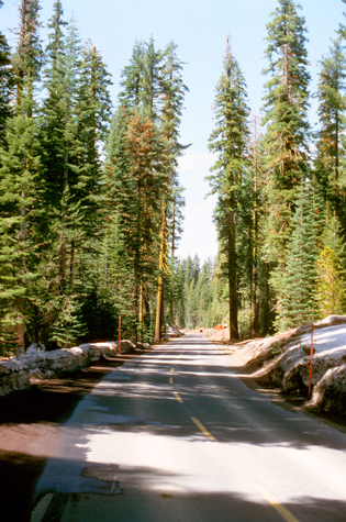
I continued on Highway 120 as it began to climb up into forested hills and passed through an area called Buck Meadows, heading through the evergreens towards the turnoff for Yosemite.
|
|
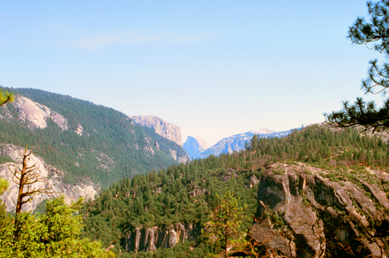
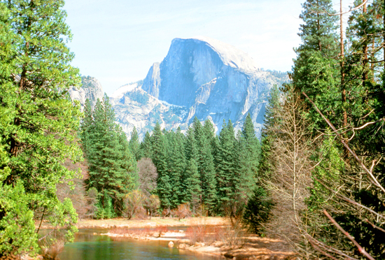
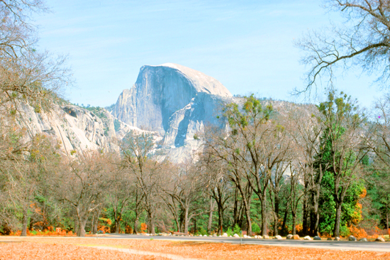
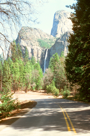
The first point of interest, according to the brochure, was a place along the road near the spot where it is said that Europeans first entered the valley. I stopped, got my camera, and walked up a short trail for my first look at Yosemite, and my first picture of it at right. In the center of the picture, in the distance, is Half Dome, and to the left of it in the picture is El Capitan- certainly two of the park's most recognizable features. This wasn't my prettiest picture of the park, but this view, or something like it, has been reproduced millions of times- many of them on postcards.
Yosemite Valley has been inhabited for nearly 3,000 years, although humans may have first visited the area as long as 10,000 years ago. The indigenous natives called themselves the Ahwahnechee, meaning "dwellers in Ahwahnee" (the Native American name for the Yosemite Valley). The indigenous peoples traded and hunted; vegetation and game in the region were similar to that present today; acorns, other seeds and plants, salmon, and deer.
|
The California Gold Rush in the mid-19th century dramatically increased travel by European-Americans in this area, causing competition for resources between the indigenous people and the miners and their entourage. In 1851, as part of the Mariposa Wars intended to suppress Native American resistance, United States Army Major Jim Savage led the Mariposa Battalion into the west end of Yosemite Valley in pursuit of Ahwahneechee warriors, and battalion journals became the first well-documented reports of Europeans entering the valley.
|
Correspondence and articles written by members of the battalion helped to popularize the natural wonders of the Yosemite Valley and the surrounding area. The Ahwahneechee were eventually captured, relocated to a reservation near Fresno, allowed to return to the valley, attacked gold miners, took refuge with the Mono Lake Paiutes, and stole from them. The Mono Paiutes killed most of them, and absorbed the rest into their tribe.
A number of Native Americans continued to live in Yosemite and became part of the tourism industry, working as laborers or maids or selling baskets to and performing for tourists. I didn't see them, but what I did see, as soon as the park road leveled out in the valley itself, was one of its iconic sights.
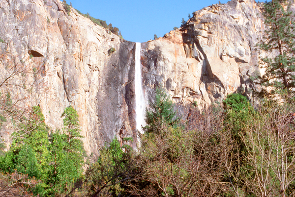
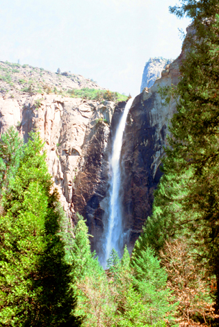
 Bridalveil Falls |
(Picture at left) This was my first view of Bridalveil Falls. One of the most prominent waterfalls in valley, the fall is 600 feet high and flows year round. The glaciers that carved Yosemite Valley left many hanging valleys that spawned the waterfalls here. With the exception of Bridalveil Falls, these have eroded into steep cascades. Bridalveil Creek still leaps into the valley from the edge of the precipice, although that edge has moved back into an alcove from the original edge of the valley.
(Picture at right)
|
 From the Falls Parking Area |
When I got into the valley, I decided just drive along the park roads, going from one feature of the valley to another. I'll try to put my pictures pretty much in sequence through the day, but sometimes I'll group them by feature. If you want to orient yourself and see about where my pictures were taken, here is a park map (current as of 2019):
 |
I should make one comment about driving in the park, though. This year, when I was visiting, almost all the park roads were two-way (except for some one-way loops at the east end of the park). Some years after this visit, so many people had begun driving into the park that it was necessary to make the main road on the north side of the river one-way going west, and the road on the south side, where I started out, one-way east. (You'll see cars going in two directions in many of my photos). Even more recently, the park has gotten so crowded that at peak times, visitors must park in lots outside the valley and ride trams and shuttle buses through the park itself.
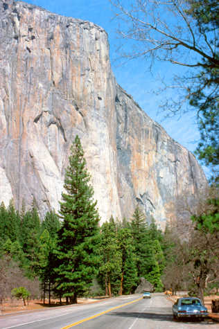
There are two major mountain features that every visitor can see without taking a hike into the back country. The first is El Capitan, and the north side park road goes along the base of the sheer rock walls that form the feature. (There is a peak, but it can't be seen from the valley floor.)
|
|
The impression from the valley floor that this is a round dome that has lost its northwest half is an illusion, as from a different angle, Half Dome can be seen as a thin ridge of rock, called an "ar�te", that is oriented northeast-southwest, with its southeast side almost as steep as its northwest side except for the very top.
As late as the 1870s, Half Dome was described as "perfectly inaccessible" by Josiah Whitney of the California Geological Survey. The summit was finally reached by George G. Anderson in October 1875, via a route constructed by drilling and placing iron eyebolts into the smooth granite. Today, Half Dome may now be ascended in several different ways. Thousands of hikers reach the top each year by following an 8.5 mi trail from the valley floor. After a rigorous 2 mi approach, including several hundred feet of granite stairs, the final pitch up the peak's steep but somewhat rounded east face is ascended with the aid of a pair of post-mounted braided steel cables originally constructed close to the Anderson route in 1919.
|
|
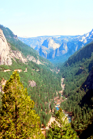
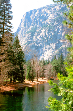
Of course, almost all of Yosemite's waterfalls directly feed the Merced River, which first formed as the Sierra Nevada rose about 10 million years ago, and sediment eroded from its canyon helped form the flat floor of the San Joaquin Valley. Glaciation during the Ice Ages carved the high elevation parts of the watershed, including Yosemite Valley, into their present shape. Historically, there was an extensive riparian zone which provided habitat for millions of migrating birds, and the river had one of the southernmost runs of chinook salmon in North America.
The river was probably the prime reason why the Yosemite Valley was inhabited so early, and also a prime engine for the development of the area, including mining and tourism. It is here in the Yosemite Valley that the Merced River is at its most beautiful, and it appears to be an unspoiled natural wild river. The lower Merced River, out in the San Joaquin Valley, is a different story altogether. Large-scale irrigation was introduced there in the late 19th century, and led to the construction of numerous state, federal and privately owned dams, which blocked migrating salmon and caused a large decline in riparian habitat. Diversion of water for irrigation often reduces the river to a small stream by the time it reaches its mouth.
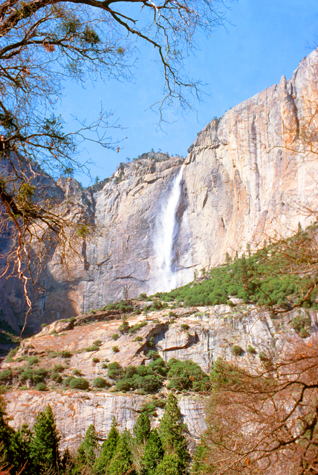
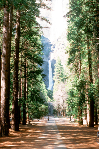 Lower Yosemite Falls |
(Picture at left) At one point in my drive, I parked on the north side of the valley near one of the visitor centers and followed this beautiful walkway to the beginning of the trail leading to the base of the lower Yosemite Falls. The trail wasn't very long, and the base of the falls was neat, and there was a lot of mist.
(Picture at right)
|
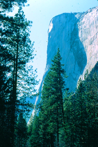 El Capitan |
Returning from the base of the falls, I decided to leave the car where it was for a while and just enjoy walking around the area near the visitor center. The day was simply beautiful, and the park not yet very crowded with seasonal tourists- as the temperature was in the low 60s.
|
|
But, like I said earlier, the side of the formation that you can't see isn't really a smooth dome, but another vertical face (although less sheer that the face you see here).
I spent the better part of an hour just wandering around the valley floor; it's difficult to describe just how beautiful this place really is, and how restful simply appreciating that beauty actually is. I can easily see what survey after survey reveals that Yosemite is considered the most beautiful of all the National Parks.
|
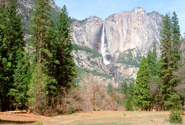
The Middle Cascades aren't visible from the valley; but the four small plunges total 675 feet taken together, but because of the narrow, constricted shape of the gorge in which these drops occur and the fact that only by hiking an hour or so up the trail to the top can they be seen very well, they are rarely noted. The final 320-foot drop (the Lower Cascade) is easily accessible, and most visitors to the Valley hike to its base, which is a jumble of wet, slippery talus, and often very misty.
In all but the wettest years, the falls cease flowing altogether in late summer or fall, so it was nice to be here at this time of year. One of these days, I would like to return and do the 3.5-mile hike to the top of the falls; I can only imagine that the view is spectacular.
The main village of the native people of Yosemite Valley, the Ahwahneechee, was located at the base of the falls. They called the waterfall "Cholock" ("the fall") and believed that the plunge pool at its base was inhabited by the spirits of several witches, called the Poloti. An Ahwaneechee folk tale describes a woman going to fetch a pail of water from the pool, and drawing it out full of snakes. Later that night, after the woman had trespassed into their territory, the spirits caused the woman's house to be sucked into the pool by a powerful wind, taking the woman and her newborn baby with it.
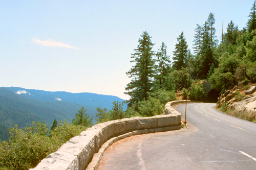
I reluctantly got ready to leave the beautiful valley, as I didn't want to be driving back to the city entirely in the dark. I also wanted to get some additional pictures from Inspiration Point, now that the light was getting into just the right position for the best pictures. I got in the car and headed back out the park road, and took this series of good pictures on my way home. These were so nice that I want to show them to you in as large a format as possible, so to see each one, click on its little thumbnail image below:
|
This was a wonderful day trip to an extraordinarily beautiful place. I intend to return here- perhaps often- and hope to do some of the hikes that I had to eschew today.
You can use the links below to continue to another photo album page.
|
June 12-14, 1976: A Drive to Reno, Lake Tahoe, and Yosemite |
|
April 10-11, 1976: Exploring the Peninsula |
|
Return to Index for 1976 |