|
April 17, 1976: A Day in Yosemite National Park |
|
February 15-28, 1976: A Triangle Trip: Seattle, Anchorage, and Honolulu |
|
Return to Index for 1976 |
Working on the software in San Francisco continues to be one of the nicest experiences of my Cullinane career- mostly because San Francisco and the Bay Area is so enjoyable. Just being in the city, staying at Greg's and walking back and forth to work each day is very enjoyable. The project is moving along, and I am getting very familiar with the entire area, as I take every opportunity, as I am doing this weekend, to explore San Francisco, the Peninsula, and the Bay Area. Greg is gone this weekend, so I've borrowed his car and am going for a drive south of the city.
|
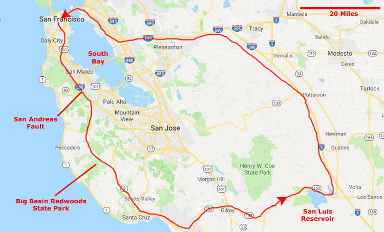
At right is a map of the Peninsula as well as Santa Cruz County to the south of it, and across over Mendocino County to the east. Some other counties are also covered, but the map will give you an idea of how big an area I covered. My total route covered maybe 250-300 miles over the two days, but as I was stopping frequently just to see stuff, it took longer than just getting in a car and driving 300 miles on a freeway.
I have marked some of the locations that I'll mention in conjunction with the pictures below. I suppose the title of this page is a bit of a misnomer, as "the Peninsula" when you are in San Francisco refers to the area south of the city itself and down through the towns of Palo Alto, Mountain View, and Los Altos. The Peninsula separates San Francisco Bay from the Pacific Ocean. Whereas the term "the Peninsula" technically refers to the entire geographical San Franciscan Peninsula, in local jargon, "the Peninsula" does not include the city of San Francisco. Nor does it include the areas from San Jose southward, or anything east of South Bay. These areas are typically referred to by their county names, or with the terms "South Bay" and "East Bay". (Similarly, the locals refer to anything on the north side of the San Francisco Bay Bridge simply as "Marin County", although the area is its own peninsula.
Anyway, just use the map to kind of follow me along as I wander south, east, and then back north over the course of the weekend.
|
|
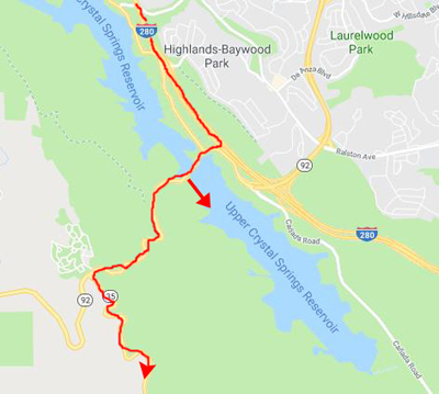
The southern lake, seen in my picture, was formed when a tributary, Laguna Creek, which joined Laguna Grande at the south end, was submerged by construction of an earthen dam (this was the first Crystal Springs Dam) in 1877. The old earthen dam became a causeway between Upper and Lower Crystal Springs Reservoirs when the latter was formed by Herman Schussler's 150 foot tall concrete Crystal Springs Dam, which dammed up San Mateo Creek to form the lower reservoir in 1888; that is the causeway that Highway 92 crosses. The reservoir is fed by other small creeks as well.
The San Andreas Fault, of course, is the tectonic boundary between the Pacific Plate and the North American Plate, and it comes ashore in California at San Francisco and then extends 750 miles into Southern California. The fault divides into three segments, each with different characteristics and a different degree of earthquake risk. The slip rate along the fault ranges from 3/4 to 1.5 inches a year. The fault was identified in 1895 by Professor Andrew Lawson of UC Berkeley, who discovered the northern zone; it was named after the surrounding San Andreas Valley. Following the 1906 San Francisco earthquake, Lawson concluded that the fault extended all the way into southern California. At some point, there will be another big earthquake along the fault; I just hope I am not in San Francisco when that happens.
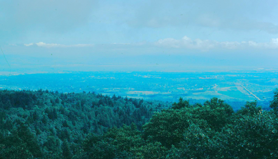
I turned south on California 35, a very scenic road just on the crest of the mountains, with expansive views in both directions. Both of these pictures look east, across the fault and towards South Bay:
 |
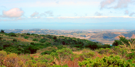 |
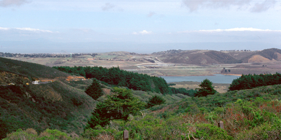
I am driving southeast on the Peninsula now, on State Route 35, which runs along the ridge of the Santa Cruz Mountains; it is known as "Skyline Boulevard", while Interstate 280 is east of the ridges. The drive was incredibly scenic.
|
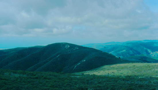
The northernmost portion of the Santa Cruz Mountains, north of California 92, is known as Montara Mountain; the middle portion is the Sierra Morena (where I am now), which includes a summit called Sierra Morena; and the southern portion, south of Lexington Reservoir, is known as the Sierra Azul.
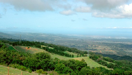
The highest point in the range is Loma Prieta Peak, which is almost 3800 feet high. (If that name sounds familiar to you, it's because it was the epicenter of the 1989 Loma Prieta earthquake. That quake, the most significant since the major quake of 1906, was seen, live, by millions of people, as it occurred just as a game of the 1989 World Series was getting underway at Candlestick Park. You may also remember the iconic pictures of the incident that took most of the 65 lives lost- the collapse of a long section of the Nimitz Freeway in Oakland.)
The mountains were very beautiful, although a couple of times I took pictures looking towards the sun, and my camera compensated by darkening everything. The mountain chain also has five or six other peaks at 2500 feet or higher, and of course the San Andreas fault runs right alongside the ridgeline. From a point of view some twenty miles further south, here are two views looking eastward across San Jose to the South Bay terminus:
 |
 |
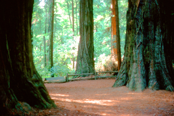
I continued driving along the crest of the mountains, heading generally south towards Santa Cruz. That's when I kind of stumbled across Big Basin Redwoods State Park. The state park is about 22 miles northwest of Santa Cruz, and it contains almost all of the Waddell Creek watershed, which was formed by the seismic uplift of its rim, and the erosion of its center by the many streams in its bowl-shaped depression.
|
The park actually has over 80 miles of trails. Some of these trails link Big Basin to Castle Rock State Park and the eastern reaches of the Santa Cruz range. At the park entrance, I stopped to read a bit about the trails, and I found one- the "Skyline-to-the-Sea Trail"- that I thought I would like to come back and hike one day; it threads its way through the park, beginning at its highest point near the park entrance, and then pretty much following a creek all the way down to the beach and the adjacent Theodore Hoover Natural Preserve, a freshwater marsh.
According to the signage near the parking area, the park has a large number of waterfalls, a wide variety of environments (from lush canyon bottoms to sparse chaparral-covered slopes), many animals (deer, raccoons, an occasional bobcat) and abundant bird life – including Steller's jays, egrets, herons and acorn woodpeckers.
I spent about an hour and a half walking around the park. These were the second redwoods that I've seen, as Greg and I have been to Muir Woods up in Marin County once or twice. As I was coming down off the ridgeline on my way south, I took this picture looking ahead to Santa Cruz. As it was getting late in the day, I stopped for the night just north of Santa Cruz.
|
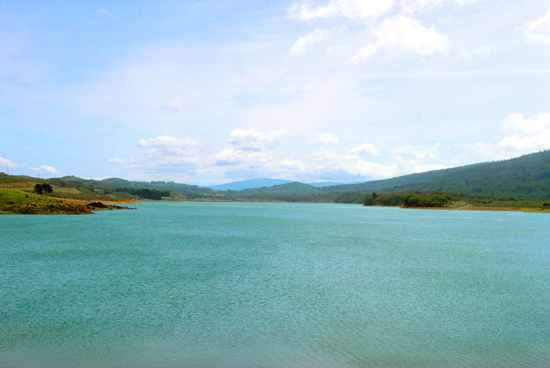
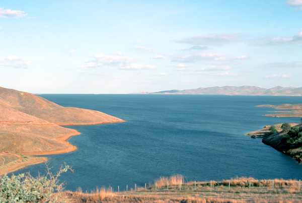
The San Luis Reservoir is an artificial lake on San Luis Creek on the eastern slopes of the Diablo Range of Merced County. The road I was on, State Route 152, crosses Pacheco Pass and runs along its north shore. It is the fifth largest reservoir in California. The reservoir stores water taken from the San Joaquin-Sacramento River Delta, some of which is pumped into the lake from the California Aqueduct. The reservoir averages nine miles by five miles, the the San Luis Dam is at its eastern end. This fourth-largest US embankment dam holds back over 2 million acre-feet of water.
Completed in 1967, the 12,700-acre reservoir is a joint use facility, being part of a network of reservoirs, dams, pumping stations, and 550 miles of canals and major conduits that move water across California. I learned all this at the Romero Outlook Visitor Center. The suface of the reservoir is 544 feet above sea level, and the land below the dam is 300 feet lower, which has allowed for the construction of a hydroelectric plant. San Luis Reservoir supplies water to 63,500 acres of land in the Santa Clara Valley west of the Coast Ranges.
After I reached I-5 in the early afternoon, I headed north, and even though the drive was scenic, there weren't many photo opportunities as I drove back to the Bay Area. I crossed back into Oakland near Livermore, and then drove up the Nimitz Freeway to the Oakland Bay Bridge and back into the city. I got back to Greg's place about six after a thoroughly enjoyable weekend.
You can use the links below to continue to another photo album page.
|
April 17, 1976: A Day in Yosemite National Park |
|
February 15-28, 1976: A Triangle Trip: Seattle, Anchorage, and Honolulu |
|
Return to Index for 1976 |