


 |
April 10-11, 1976: Around the San Francisco Bay Area |
 |
January 26-30, 1976: A Business Trip to Montreal |
 |
Return to Index for 1976 |
In early February, I went back to San Francisco to continue work on some software at Wells Fargo, and later that month I went back to Alaska to do a follow-up at the National Bank of Alaska in Anchorage. Because I was already in San Francisco, I was able to take advantage of a triangle fare offered by Northwest Orient Airlines. For persons going to either Hawaii or Alaska, you can fly to the other point on the way out or back for only an extra $25.
Working in San Francisco
When Greg and I pitched the project to John Cullinane, we promised we'd try to keep expenses down, and so when I am here I usually stay with Greg. Greg lives on Nob Hill, certainly a storied location, at the corner of Taylor and Clay streets. Also on Nob hill are the legendary Fairmont Hotel and also Grace Cathedral- the city's largest church.
|
|
|
When the movie begins, McQueen is in the grocery store I marked. When he comes out, and walks across Taylor Street, you can see Greg's building, and his apartment on the second floor (the floor above sidewalk level with bay windows)- it's the light green building behind McQueen (its been painted since then). Greg was actually living in the building at the time, although he tells me he was at work when they were filming.
I spent a week working at Wells Fargo before my trip to Anchorage.
My Business Trip to Anchorage
|
Before airline deregulation, airlines had to apply for routes, and the FAA made sure that every route was spoken for by at least two airlines, and that no routes were overfilled by lots of them. The Honolulu-San Francisco route was a popular one, and coveted by five or six airlines (and those five or six airlines were given permission to fly it). The San Francisco-Anchorage route was considerably less popular, and only a few airlines applied for that route. As it turned out, there were two or three airlines that flew all three routes, with the Anchorage-Honolulu route being by far the least traveled.
So the airlines found that the could attract customers for their Alaska-California legs if they offered a triangle fare. Northwest Orient airlines was one of these, and it was the airline I flew from San Francisco to Anchorage. To attract customers for that trip, and since they also flew the other two routes, they offered customers the chance to, instead of flying SFO-ANC and back, fly SFO-ANC-HNL-SFO for only an additional $25. The same offer was made for anyone flying SFO-HNL and back; they could add Anchorage for another $25. This attracted customers, helped fill their planes flying the HNL-ANC route, and also helped tourism in both Hawaii and Alaska (and I am sure the airline got a piece of tourist pie for persons on the triangle fare.
So that's what I'm doing this time- business in Anchorage followed by pleasure in Honolulu. The first leg of the trip was up to Seattle, a two-hour ride. Coming into SeaTac Airport, the weather was very cloudy.
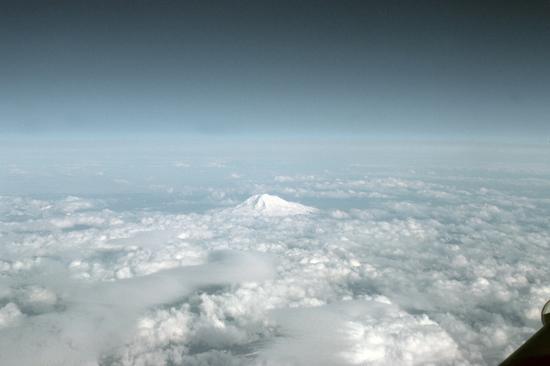 The flight to Seattle was pleasant, and on the way into the area I got a great picture of Mt. Rainier. |
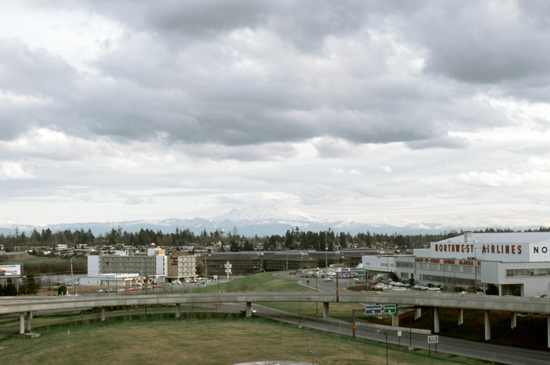 As it turned out, I didn't have to change planes. This is the old Seattle-Tacoma airport, and Mt. Rainier in the distance. |
From Seattle, the route of flight parallels the Canadian and Alaskan coasts to Anchorage. In this area, the coast is made up of numerous islands, most of which are not inhabited. As one goes North, snow becomes more and more in evidence, first at the higher elevations and then progressively lower. The scenery as we continued north was pretty amazing, and it was neat that for once I had a talkative pilot, as I was unfamiliar with the terrain below.
|
It was pretty dark when we came in for a landing; in the winter here at this latitude it doesn't really get light at all until eleven in the morning, and what sun there is has usually gone back below the horizon three or four hours later. So it seemed like the middle of the night when we landed about 8PM.
With no landing pictures to show you, I've instead put an aerial view at left of Anchorage and the surrounding area (taken, I would suspect, in the summertime, since only the mountaintops are snow-covered. But it will give you an idea of the lay of the land around Anchorage.
This being February, the weather was brutally cold (although, I should point out, warmer than in Chicago, as Anchorage is located on the water, which is kept warmer than you might think by the Pacific current). Chicago, being inland, gets more temperature extremes than does Anchorage. This was my second time here, and on my first trip it was warmer here than at home as well. I did bring the heaviest coat I had, and I was glad for that.
|
Anchorage has a couple hundred thousand people, and is Alaska's most populous city with more than 40 percent of the state's total population; among the 50 states, only New York has a higher percentage of residents who live in its most populous city. At 1,706 square miles of land area, the city is the fourth largest city by land area in the United States (and larger than the smallest state). The top three cities on the list, you may be curious to know, are Sitka, Juneau, and Wrangell- all also in Alaska. This takes some explaining. In Alaska, these four cities have officially extended to the boundaries of their boroughs (counties), even though only a small fraction of the borough is actually what you'd think of as urban.
For you trivia buffs, the largest American city outside of Alaska is in a state at the opposite end of the weather extreme- Jacksonville, Florida. But that city, too, actually takes up its whole county, even though most of the county is open land. If you are curious, you have to get down to the eighth city on the list to find the largest American city that is NOT coterminus with its county- Oklahoma City, Oklahoma (606 square miles).
Anchorage is at the end of the Cook Inlet, on a two-armed peninsula, and has won the All-America City Award twice- in 1956 and 1965. The city can trace its settlement to the 19th century, when Alaska was owned by Imperial Russia. In 1867, U.S. Secretary of State William H. Seward brokered a deal to purchase Alaska $7.2 million, or about two cents an acre. In 1888, gold was discovered near Anchorage, and Alaska a United States territory in 1912. But without significant a significant fishing industry, and no mineral resources to speak of, Anchorage stayed a sleepy hamlet.
|
On March 27, 1964, the magnitude 9.2 Good Friday earthquake hit Anchorage, killing 115 people and causing $250 million in damages. The earth-shaking event lasted nearly five minutes; most structures that failed remained intact for the first few minutes then failed with repeated flexing. It was the world's second-largest earthquake in recorded history, and rebuilding dominated the remainder of the 1960s. There are still areas where the damage has not been cleared away. In 1968, ARCO discovered oil in Prudhoe Bay on the Alaska North Slope, and the resulting oil boom spurred further growth here.
|
The temperature was actually surprisingly moderate, only about zero or so most nights, about the same as in Chicago. Even so, it was cold enough that once I returned to the hotel in the evening, I didn't do much save go out for dinner on those nights I wasn't with the audit group.
Most of our work was done out at the bank's data center a mile or so outside downtown; that's where we did the short class I conducted and we worked on some audit reports. That's also where I went outside early one afternoon to photograph the Chugach Mountains off in the distance. Most of the personnel had changed from my last visit. The Auditor last time was a middle-aged guy from a bank in Minnesota who had a bunch of us out to his house for moose stew and spaghetti with moosemeat sauce. The new Auditor is a relatively young Anchorage native about my own age who races huskies as a hobby.
It was an inteesting week, but after the cold weather I was looking forward to some tropical breezes!
My Pleasure Trip to Hawaii
|
I never tire of Hawaii. When I landed in Honolulu it was past three in the afternoon, but the sun was shining brightly and it was, of course, quite warm. As we taxiied to the gate, I was looking forward to spending four relaxing days in Waikiki.
I suppose this is my fourth or fifth trip to the Islands over the years. The very first was a stopover on my return from South Korea in 1970. Tony and I have come out here once or twice for Cullinane, and I guess that I have come here two or three times on vacations as well.
When I have been here before, I've been in the habit of staying at the Sheraton Waikiki, in what was called The Garden Annex- a low building right beside the hotel tower. (It was torn down in the 1980s to make room for an expansion of the tower itself.) The hotel didn't charge nearly as much for the rooms, as they weren't high up and didn't have great views, but when you are here on business, that really doesn't matter.
|
|
As it turns out, the Waikiki Village and some other, smaller hotels on this street were all redeveloped into the Embassy Suites Waikiki Beach Walk in the late 1990s. That whole Lewers Street area was redone and reopened in 2007. I've marked that development on the aerial view at left.
Also, if you try to associate a couple of my pictures with that aerial view, you'll realize that a new high-rise has been built that pretty much blocks the former view from the Waikiki Village of Fort DeRussy.
I took four different pictures from the balcony of my room at the Waikiki Village, and there were very good views. Here they are:
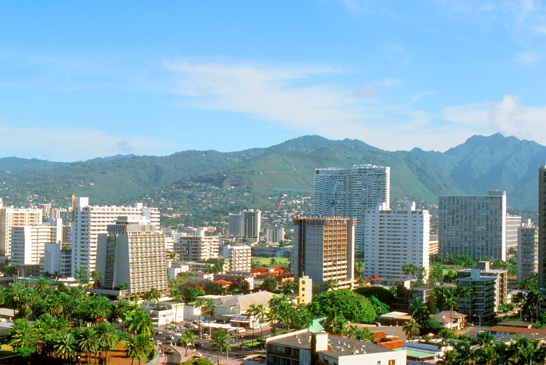 Contrast this view of Honolulu from the Waikiki Village with my view of Anchorage from the Anchorage Westward. This is the view from my balcony looking inland. |
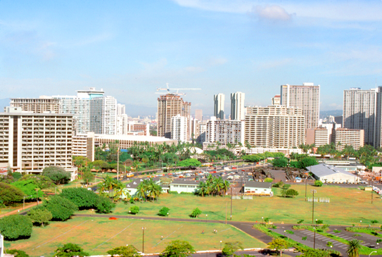 This view looks towards the business district of Honolulu, across Fort DeRussy, where I had stayed on my way back from Korea. (I walked by the Fort, and found that military accommodations were no longer available.) |
The next two photos are interesting, I think. They were both taken from my balcony and look in the same direction (you can match up the trees in both photos; even though they aren't an exact match):
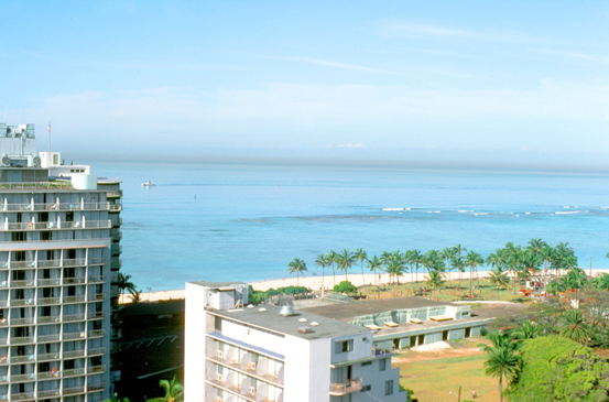 Looking Out to Sea (Daytime) |
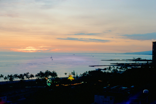 Looking Out to Sea (Sunset) |
So on this trip, I stayed in a different hotel, but my routine was pretty much the same as the last few times I've been here. Of course, being in Hawaii is all about the beach or the pool, and, not having a car this time, I spent a lot of time walking along the one and laying out at the other.
|
|
So my routine for these five days was to lay out by the hotel pool a while each day, and also walk along the beach every day. Also, I did my daily jog along Kalakaua Avenue to Ala Moana Park and then along the jogging trail that they have there. Near the park, there is a pavilion where locals sit and play chess, checkers, bridge, and backgammon, and almost every day I went down there to get into a game (bridge and backgammon only; I was out of the league of the chess and checker players, as I discovered quite quickly). I went out to eat in the evening, usually at a buffet that I favored near the hotel.
Here are the other two pictures that I took during my relaxing stay on Waikiki:
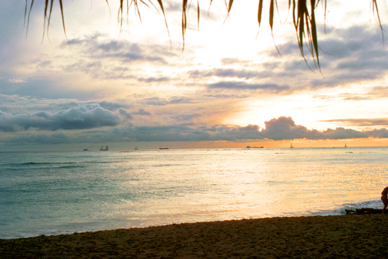 This view looks out to sea from Waikiki Beach. |
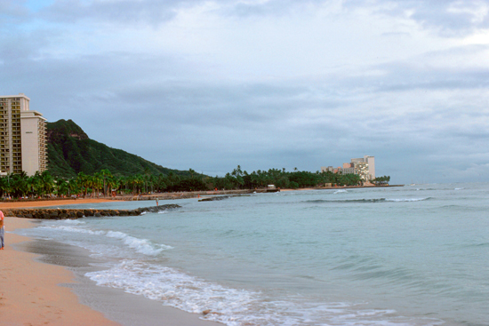 Here is a view looking east along Waikiki Beach to Diamond Head. |
It doesn't take a lot for me to be quite happy in Honolulu; my daily routine is very enjoyable and I am never bored. I had two very nice days this time and two days that were overcast and a bit rainy, but, all in all, it was a very relaxing five days before I had to head back to San Francisco and the reality of the workaday world.
You can use the links below to continue to another photo album page.
 |
April 10-11, 1976: Around the San Francisco Bay Area |
 |
January 26-30, 1976: A Business Trip to Montreal |
 |
Return to Index for 1976 |