


 |
November 9-16, 2014: A Tour of the Celebrity Xpedition |
 |
November 11, 2014: Isabela Island |
 |
Return to the Index for Our Galapagos Adventure |
Today, we will come back around to the northeast shore of Santiago Island to walk across some relatively new lava flows. In the afternoon, we will go a very short distance east to Bartolome Island, where we will hike to the island's summit to take in the spectacular views. After that, Fred and I will try our hand at snorkeling again.
Morning on the Celebrity Xpedition
 |
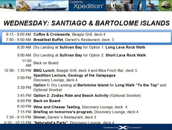 |
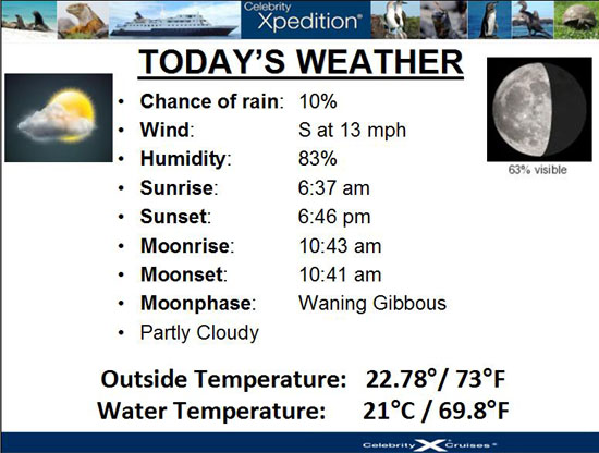
Today, we'll be getting up fairly early to leave the ship at 830AM to take one of the Zodiacs in to Sullivan Bay on Santiago Island. So there wasn't much time or opportunity to do much except get our breakfast and get ready to leave the ship.
|
Our afternoon destination would be Bartolome Island, which we could see a mile or so away across the water. With his zoom and my camera, Fred and I took a few pictures from this distance (pictures we wouldn't be able to get once we were on the island). You can see the beginning of the boardwalk we will be on as well as the little lighthouse on top. Click on the thumbnail images below to see some of these pictures:
 |
Also, looking out ahead of the ship across the water, we could see the rocky lava coast where the Zodiac would be taking us this morning.
Galapagos Shore Excursion (5):
Lava Walk on Santiago Island at Sullivan Bay
|
| "Sullivan Bay is nothing short of a geologic wonderland. Located on the southeast shore of Santiago Island, the area is covered by the twists and turns of ropey Pahoehoe lava flows. Iridescent swirls of hardened lava, collapse craters, old lava tubes, and Hornitos decorate this relatively modern volcanic landscape. We“ll make it a morning hike to minimize the heat while walking across fields of black lava. Duration: About 2 hours" |
We boarded a Zodiac right at 0830 and ten minutes later we had landed on the shore of the lava flow that we would be exploring. As we headed off, we could look back out to sea and the Xpedition. There were a lot of other boats, too; this is a popular place (although many of the folks on those other boats anchored offshore might have either been snorkeling or on Bartolome Island nearby).
|
We will look at our pictures in a minute, but first let me use some of them to illustrate some general information about what we'll be seeing.
Volcanism in the Galapagos
|
The oldest Galapagos island was formed in this way. But, unlike most volcanoes on land, the fissure or weak space in the crust ("hotspot") through which the magma poured was at the boundary between tectonic plates, and when they moved, the fissure moved. So, the next time there was an eruption, the process began again and a new island was formed. The older islands, no longer being built up, began to erode and weather away. In the Galapagos, the oldest islands in the east have all but disappeared. The hotspot has moved steadily west, and is now fueling the growth of the newest island, Fernandina.
(The same is true in Hawaii, where the oldest islands are at the northern end of the chain while the newest and still volcanically active, The Big Island of Hawaii, is at the southern end of the chain.)
Galapagos lava is formed from basalt, the most basic of all types of lava. Basalt has a very different chemical composition from the lavas that erupt from continental volcanoes, and is much more fluid. Consequently, as the lava flows build up to produce a volcanic cone, the island cones have a much shallower slope than those on the mainland. These shallow-sloped volcanoes are called shield volcanoes and in the Galapagos, they are often compared to over-turned soup bowls. Such shield volcanoes can clearly be seen in the younger western islands of Isabela and Fernandina. To the east, the volcanoes are lower and more eroded.
|
Although we did not visit it, the remains of Tortuga Island, at the eastern end of the Galapagos Island group, is an excellent example. All that is left of the once solid island are the highest portions of the rim of the caldera of the volcano that formed it. Eventually, as the island sinks, even this ring of stone cliffs will disappear.
The Lava Flow We Traversed
|
Click on the thumbnail images below to see some additional views of the volcano cones near Sullivan Bay:
 |
In another view, you can look all the way across the island to the volcano at the southwest side of the island, which has also erupted in historical times. You can see that view here.
I also did a panoramic view of the lava flow and some of the volcano cones beside it, just before we started off on our walk. You can see that panorama below:
 |
So now, let's look at some of the things that our guide pointed out, and I guess we should start with the lava itself.
Pahoehoe (pa-hoy-hoy) Lava
|
 |
In the first two images, you can see the underlying flow is actually another layer of pahoehoe lava; there must have been a third layer down. When the top layer solidified in place, the next layer down was also cooling and moving slowly, and it eddied into the same ropy formation. In the third picture, you can see that the underlying layer must have been moving swiftly enough so as not to form those same formations. We can also tell that the lava of that layer must have solidified fairly quickly- probably because the pahoehoe layer broke open and exposed the layer beneath.
I came across a place where the pahoehoe lava had fractured perpendicular to the rope formation, and part of it had broken away; this enabled me to see a pahoehoe cross‑section. You can see that there are actually ropes on ropes in this type of flow- not just a single layer. At other places on the lava flow we walked, we could see that the pahoehoe was only a single thin layer.
Early in the flow, when the lava is hotter, these twists have the appearance of ropes, but later, as it cools and becomes more viscous, the twists are shaped more like entrails. Underneath the solidifying surface, the liquid lava continues to flow, often draining out and leaving hollow cavities which later collapse.
|

|
The pahoehoe lava formations seemed to occur in patched; much more of the lava seemed to be of the second type.
Aa (ahh) Lava
|
Most of the lava flows here at Sullivan Bay were pahoehoe, but examples of the more aa-like type can be found- usually at the head of the flows. These are not classic examples, but serve to illustrate the difference. You can click on the three thumbnail images below to see the three of us standing in the area of more aa-like lava at the shore:
 |
In Galapagos aa flows tend to be more abundant than pahoehoe flows, but they are rare at visitor sites - for obvious reasons. (Here on Santiago, where almost all the flows are pahoehoe, one can only see small sections of this type of lava.
Mollugo
|
This rare plant has its own evolutionary story to tell, as it has evolved into species endemic to particular lava flows. Here at Sullivan Bay, the species is actually Mullugo crockeri.
Mollugo can be a colorful plant, particularly against the dark brown or black expanse of the lava that it colonizes. Click on the thumbnail images below for two more views of this interesting plant (only two stands of which we found):
 |
Lava Cactus
|
As its name suggests, the lava cactus occurs exclusively on barren lava fields, lying at sea level. Not only is it one of the few plants that survive in this extremely dry, challenging habitat, it is often one of the first plants to colonize a fresh lava flow.
Despite the scientific interest that the Galįpagos Islands have received ever since Darwin visited in 1835, and the numerous observations of the lava cactus, the biology of this plant remains poorly known. Like all cacti, this succulent plant is capable of storing moisture in its stems when water is available, enabling it to survive periods of drought, and the spines, which are actually the leaves of the cactus, provide defense against any plant-eating animals.
If you would like to see more of this interesting plant, you can click on the thumbnail images below for some other clumps of the plant that we found during our walk:
 |
While the Galįpagos are a protected area, and are considered one of the most unspoiled areas remaining on the planet, the fauna and flora of these islands still face major threats, such as introduced species, pressure from increasing tourist numbers, and a decline in the maintenance of protective laws. However, the lava cactus is not currently known to be facing any specific threats. It is considered vulnerable based primarily on its restricted distribution. It is listed as a vulnerable species by the International Union for Conservation of Nature.
Lava Tubes and Lava Caves
|
Our group encountered one small lava tube, which was only a few feet high and wide. We would not have known we were walking over it if a small portion of the solidified "ceiling" had not collapsed and left this keyhole‑shaped opening. There were no rules involving rock formations on the Galapagos (except that you must not remove any of them), so I decided to lower myself into the tube and let Fred get a picture or two. In the picture at left, he included the feet of some of our group so as to provide some scale.
As the group moved off, I thought I would get out my extender and see if I could get a good picture of myself standing in the lava tube. It worked tolerably well, and I ended up with a pretty good " lava tube selfie".
There are places, Hawaii comes again to mind, where volcano lava flows have, over time, been turned into lava caves (the distinction seeming to be that a lave tube is a tube, and everything else is a lava cave). We did not find any caves of any real extent (probably because this flow is so close to the shore and so recent), we did come across one that satisfied my need to climb down into it.
|
 |
|
|
After I finished the movie, I climbed out of the cave and found myself playing catchup to rejoin the group.
As far as other cracks and crevices were concerned, there were many of them. In spots, what had once been the solid crust with lava flowing underneath had cracked and buckled. And we ran across a couple of places where the crust layer had not collapsed so much as been pierced by the pressure of the still molten lava underneath. This created like of a lava blow hole and you can see in that picture how some of the lava bubbling up from underneath had created a very small cone-shaped formation.
You can see a different kind of that same formation here. Apparently the underlying lava did not drain away in this case, for there no cavity left below the cone. What was interesting was the spattering around this cone. The lava must have been very viscous, but not enough to flow. The spattering around the opening looked and felt very much like volcanic glass.
Sulfur Cracks
|
Sometimes, if the lava buckled a great deal, you could see the sulfur deposits clinging to the sides of the fissures as well. These sulfur deposits were just about the only bits of color that we saw anywhere on the flow (save for the flora, of course), and I thought they were very interesting. If you would like to see some more examples of this, just click on the thumbnail images below:
 |
The Most Recent Lava Flow
|
But we walked around a low hill that had caused the flow to divide, and came to an area where you could see that the flow again found an area where gravity brought it downward towards a low valley. Had the eruption not come to an end, this low area might have been filled with new rock, but as it was, the eruption did end and this particular part of the lava flow froze in place.
This happened just in time for yours truly.
I thought that it was this contrast between the red, rocky cinder cone and the new, much darker-colored lava that was interesting (reminiscent of the flows we'd seen in Hawaii where new lava had flowed through vegetation and come to a stop).
|
To view the slideshow, just click on the image at left and I will open the slideshow in a new window. In the slideshow, you can use the little arrows in the lower corners of each image to move from one to the next, and the index numbers in the upper left of each image will tell you where you are in the series. When you are finished looking at the pictures, just close the popup window.
Before I left the top of the hill to rejoin the group, who were heading south a bit before turning back toward the bay, I got Yoost to participate in a panorama. I took a series of pictures, beginning with one where Yoost was standing near me. Then, as I took the other pictures in the series, he went on down the hill to follow the group on the trail to the south. He appears again in the last of the pictures I took- much further away and on the trail back. Use the scrollable window below to pan across the picture, and notice Yoost at the left and at the right:
From here, our group moved back across the main lava flow towards the bay. We saw more of what we'd seen on the way out on our walk, but we saw some new things as well- a different type of lava cactus, some finches and lots of interesting lava formations.
|
To view the slideshow, just click on the image below and I will open the slideshow in a new window. In the slideshow, you can use the little arrows in the lower corners of each image to move from one to the next, and the index numbers in the upper left of each image will tell you where you are in the series. When you are finished looking at the pictures, just close the popup window.
|
The walk was really neat, and we saw quite a bit, and when we got back to the beach we had a little while to wait until the next Zodiac came to get us.
I used this time to take the series of pictures that I would need to construct a complete, 360° view of Sullivan Bay and the lava flows we had traversed. I have put this panorama in the scrollable window below so that you may pan across it:
Lunch Aboard the Celebrity Xpedition
|
Just before we had lunch, I spent some time talking with our Friend Eileen about the daily emails Fred and I sent out. Meanwhile, Fred went out to the grill to get a plate of lunch; he brought it back and set it down near me to snap a picture (the one you see at left). While Fred ate and kept an eye on the laptop, I went to get my own.
After lunch, and before our next shore excursion, there was a lecture in the lounge on the Geology of the Galapagos; much of the information I used to describe the pictures taken during this morning's shore excursion came from that lecture.
Galapagos Shore Excursion (6):
A Long Walk to the Summit of Bartolome Island
|
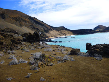
| "Bartolome Island is one of the most spectacular geologic settings in the Galapagos. As one of the relatively younger islands, its volcanic origins are easy to see. The view from the top of the island (volcano) is perhaps the most famous in all the Galapagos.
The hike up is at times steep and over 300 stairs, but the view is worth it. There will be a dry landing for the hike, but a wet landing at the beach for the snorkeling. The hike will be across a boardwalk and staircase; 380 steps will be involved from the landing site to the summit, about 400 feet above sea level. Duration: About 2.5 hours" |
The Zodiac Ride in to Bartolome Island
 |
 |
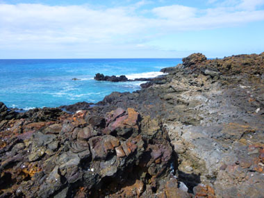 |
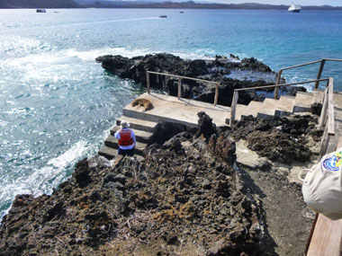
As you can see, we had a small welcoming committee that we had to step around carefully, since he showed no interest or inclination to get out of our way as we came up from the Zodiac.
The Walk to the First Overlook Platform
|
|
I took a number of pictures on the way to and at the first platform where we stopped, and you can click on the thumbnail images below to see some of them:
 |
This first part of the hike had only a few steps, but we could see that the steeper part was coming up.
Climbing to the Second Platform
|
|
From this platform, we got a good view of the Xpedition in the bay, and we could also see the large clump of lava cactus on the hill just below us. Fred used his zoom to get an excellent close‑up view of the cactus.
From the platform, I took a picture of Fred, who was standing on the section of the boardwalk between the "intersection" and the platform on which I was standing. Looking behind Fred, you can see the boardwalk curving up and away to the right towards the next observation platform and, just a few feet behind him, you can see the part of the boardwalk that leads back down the way we had come up. Have a look at that picture here.
Climbing to the Third Platform
|
|
On the stairs up to the next platform, I took a couple of pictures of folks behind me making the ascent. You can click on the thumbnail images below to have a look at these pictures:
 |
When we got up to this next platform we found that it did, indeed, have even better views of the harbor than the second platform lower down (the one you can see in the middle picture of the set below). At this platform, we took pictures of each other, and you can see all three of these pictures if you click on the thumbnail images below:
 |
While our group was on this third platform, I used my camera's panoramic function to make one (this works better than trying to stitch individual pictures together whenever there are objects in the pictures that are likely to move). You can have a look at that panorama below:
 The View from Our Third Overlook Platform |
Platform Four
|
The boardwalk was actually elevated off the ground, probably because if everyone was trooping over the landscape it would quickly become quite a mess. (Plus it would be hard, if not impossible, for most folks to make it to the summit at all.) That said, I looked over the edge of the railing along the walkway and saw what I thought was an interesting rock formation that seemed a bit out of place amidst the other bland rocks that we had seen so far.
Leaving this platform overlook, we went back to the main walkway to continue our walk to the summit with a stop at the last of the overlooks. Looking back to the main walkway, I took a picture of Fred, and you can see the summit where we will end up shortly, as well as the main walkway behind him. Take a look at that picture here.
The Last Platform on the Way to the Summit
|
There were, of course, great views from here, and you can see some of them if you will click on the thumbnail images below:
 |
Yoost got a nice closeup of Kicker Rock and the nearby beach; this is where we will be going to do our snorkeling this afternoon.
After a number of tries, I got my camera to take a pretty good panorama from here at the last platform. The bay where the Xpedition is anchored is out of the picture to the right, but you can see Kicker Rock towards the right of the picture and, behind it, the lava flows where we had walked this morning (and from which we had taken pictures, included above, showing the view of Kicker Rock and this summit from the other direction). This panorama is below:
 The View from the Last Overlook Platform |
The Summit at Last
|
|
|
The last set of steps to the summit were the steepest of all, and when we got up near the little lighthouse, it was interesting to look way back down to the last observation platform- and you can see how far down it was. Taking that picture prompted me to take a series of four that would show the entire last sections of the boardwalk, the last two platforms, and the steps up to the summit. You can see that panorama below:
 |
It was pretty neat up here at the summit, although it was windy and hard to take movies. We did get good views of the Xpedition at anchor, and Fred was able to use his zoom to take a few telephoto closeups of the beach near Kicker Rock were we would be going snorkeling a bit later. There was already a group down there, as you can see in some of his pictures; they were the ones who chose not to make the hike up here to the summit but to take a Zodiac ride instead before their own snorkeling. Anyway, if you will click on the thumbnail images below, you can see the best of the many other pictures we took here at the summit:
 |
For the final picture of the day from here at the summit, I went and stood with my back to the lighthouse and took a series of pictures of the panoramic scene in front of me. When I stitched them together, I think the result came out well, and you can use the scrollable window below to have a look at it:
The Trip Back Down to the Pier
|

|
Back at the pier, we waited only a short while for a Zodiac to come pick us up and take us over to the beach near Kicker Rock so we could snorkel.
Galapagos Shore Excursion (7):
Snorkeling on Bartolome Island
|
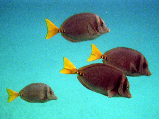
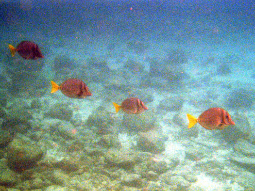
Snorkeling here at Kicker Rock was pretty good; there were quite a few different fish, and I enjoyed it. I think Fred was getting the hang of it as well. What made this outing different was that I had Nancy's disposable underwater camera to use. She asked me to use up the film and then send her a set of the prints made from the film, which I gladly agreed to do.
Now, I have no idea what the fish were that I was looking at. Some folks said they saw sharks, and other said they'd seen sea lions or other animals that are easily identified. I didn't, though, but I did take pictures of the more colorful or numerous fish that I came across.
So, unlike other places in the album pages for this trip, all I can do here is show you the best of the underwater pictures that I took. Like these:
 |
 |
As I mentioned earlier, I was able to borrow an underwater camera to take along with me on our snorkeling outing, and I actually got some good pictures.
|
To view the slideshow, just click on the image at left and I will open the slideshow in a new window. In the slideshow, you can use the little arrows in the lower corners of each image to move from one to the next, and the index numbers in the upper left of each image will tell you where you are in the series. When you are finished looking at the pictures, just close the popup window.
We really enjoyed the snorkeling sessions that we had, although it made me wish that I had a better-quality underwater camera, or at least some sort of watertight container for the little camera that I do have. I had a chance to look at some of the pictures that other folks with more professional setups took, and they were quite good, some of them.
Evening on the Celebrity Xpedition
|
|
You can use the links below to continue to another photo album page.
 |
November 9-16, 2014: A Tour of the Celebrity Xpedition |
 |
November 11, 2014: Isabela Island |
 |
Return to the Index for Our Galapagos Adventure |