


 |
August 7-9, 1998: The Texas Folklife Festival in San Antonio |
 |
July 21-26, 1998: Summer Trip to Colorado (Page One) |
 |
Return to the Index for 1998 |
NOTE:
This is the continuation page for our summer trip to Colorado.
Leadville, Colorado (7/25)
|
Leadville, the only municipality in Lake County, is situated at an elevation of 10,152 feet- hence its nickname of "The Two-Mile High City." Actually, it is the highest incorporated city in the United States. It is a former silver mining town that lies near the headwaters of the Arkansas River in the heart of the Rocky Mountains, the city includes the Leadville Historic District, which preserves many historic structures and sites from Leadville's dynamic mining era. In the late 19th century, Leadville was the second most populous city in Colorado, after Denver. Today, there are only about three thousand inhabitants.
The history of Leadville begins during the Pikes Peak Gold Rush in 1859, when a town called Oro City sprung up and soon had over 5000 inhabitants (including one Horace Tabor, one of the first prospectors to arrive). But the placer gold mining was hampered by heavy black sand in the sluice boxes (the Lord taketh away), and Oro City declined quickly. However, in 1874, geologists discovered that the sand was actually cerussite, and carried a high content of silver (the Lord giveth). The cerussite was traced to its source where large deposits were found, setting off the Colorado Silver Boom. By 1880, Leadville was one of the world's largest and richest silver camps, with a population of over 14,000.
In 1879, Tabor, who had maneuvered himself into prominence as "the Silver King," built the Tabor Opera House. (In the 20 years since his arrival he'd amassed a fortune of 10 million dollars and was known for his extravagant lifestyle. He also became Leadville's first mayor.) In 1882, it hosted Oscar Wilde during his lecture tour- just the first of many celebrities to visit. For ten years, Leadville stayed at the apex of prominence- until the repeal of the Sherman Silver Purchase Act in 1893, which led to a collapse in the price of silver. The town declined after that, although some mining companies came to rely on income from the lead and zinc deposits nearby.
|
Highway 93 ended at US Highway 24 north of town, and so when we came through the city we were on that road. Leadville was very picturesque, and when we noticed an ice cream shop open, we decided to stop for some and walk around while we enjoyed it.
The Leadville Historic District was designated a National Historic Landmark District in 1961. It includes 67 mines in the mining district east of the city up to the 12,000 foot level, and a defined portion of the town area, with specific exclusion of various buildings. Principal historic buildings in the district are: Tabor Grand Hotel, St. George's Church, Temple Israel, Annunciation Church, Tabor Opera House, City Hall, Healy House, Dexter Cabin, Engelbach House, and Tabor House, as well as mining structures and small homes.
Had we known, we would have stopped by City Hall and picked up a brochure which would have guided us on a walking tour of this historic district. But, even so, we did pass by two of the buildings on the tour.
|
On the northwest corner of 7th and Harrison, sits the Tabor Grand Hotel building. Built during the two year period of 1883 to 1885, this four story brick building was designed by noted architect of the period, George King. The hotel has had many names including the Maxwell, the Kitchen, and the Vendome. The newspaper of the day carried the following quote when the Hotel opened: “Leadville now has a hotel which in elegance of its appointments is second to none in the west and in which citizens and tourists will find all the luxuries and conveniences of the older cities.” The building was renovated and re-opened in 1992 with shops on the lower floor and apartments on the upper floors.
The closing of the Climax mine in the 1980s was a major blow to the town's economy. In addition, the many years of mining left behind substantial contamination of the soil and water, so that the Environmental Protection Agency designated some former mining sites in Leadville as Superfund sites. The town is now 98% cleaned up and the Superfund designation is about to expire. The town has made major efforts to improve its economy by encouraging tourism and emphasizing its history and opportunities for outdoor recreation.
The National Mining Museum and Hall of Fame opened in 1987 with a federal charter. The town's altitude and rugged terrain contributes to a number of challenging racing events, such as the Leadville Trail 100 series of races. It is often used as a base for altitude training and hosts a number of other events for runners and mountain bicyclists. Boom Days, held on the first full weekend of August, is a tribute to the city's mining past, and there is a winter festival as well. For some reason, Leadville also holds more parades than any other US city (including the quirky "St. Patrick's Day Practice Parade").
The Arkansas River (7/25)
|
Continuing south, we finally found out the name of the stream; it was the Arkansas River. We did not learn until later that this little mountain stream would, further down its course become a major tributary of the Mississippi River. The Arkansas generally flows to the east and southeast as it traverses the US states of Colorado, Kansas, Oklahoma, and Arkansas. The river's initial basin starts in the Arkansas River Valley, which begins south of Leadville and which we were driving through now, with waters coming from snowmelt in the Collegiate Peaks on our right as we head south. Then it flows east into the Midwest via Kansas, and finally into the South through Oklahoma and Arkansas.
We might, in retrospect, have called this entire vacation our "River Headwaters Trip." We began by camping beside the small stream that becomes a boundary between nations- the Rio Grande. We crossed the headwaters and drainage area of the Gunnison River when we drove north of the National Park. Driving along I-70 towards Silverthorne, we paralleled a relatively small stream, but one that would eventually create the major feature of the American Southwest- the Colorado River. And, now, we are seeing and hiking down to the small stream, no more than twenty feet wide, that would eventually become the mighty Arkansas.
The difference between the Arkansas River out out windows now, and the Arkansas River when it flows past Little Rock to the Mississippi could not be more stark and interesting:
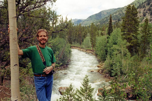 The Arkansas River in Colorado |
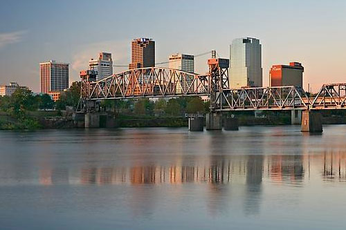 The Arkansas River in Arkansas |
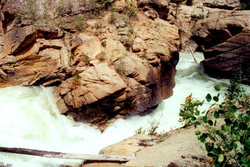
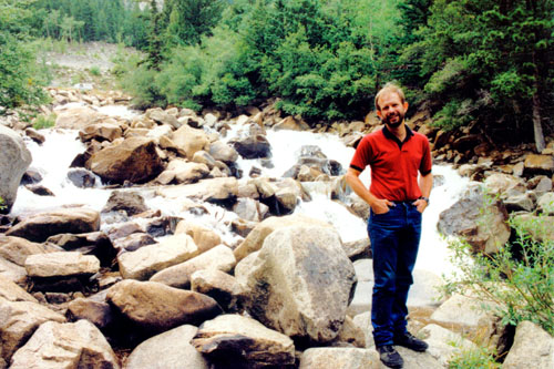
At 1,469 miles, the Arkansas is the sixth-longest river in the United States, the second-longest tributary in the Mississippi–Missouri system, and the 45th longest river in the world. We are driving now through its origins; the mouth of the river is at Napoleon, Arkansas. Its drainage basin covers nearly 170,000 sq. mi. In terms of volume, it discharges 41,000 cubic feet per second into the Mississippi. Where we are now, though, my estimate is (using the dimensions of the room in which I am currently sitting) that the volume of water tumbling over the rocks beside the road is much less than one percent of that.
 |
 |
This part of our drive down US 24 was really incredible, and for more than an hour, we marvelled at the mountain stream beside us, getting out frequently to walk down to the river to take pictures. You can click on the thumbnail images below to see many of the pictures we took along the way:
 |
Like yesterday, this was one of the most pleasant drives of the entire trip.
The Ghost Town of St. Elmo, Colorado (7/25)
|
The road also became more winding, but it was not a difficult drive, and became more pleasant when yet another mountain stream flowed beside the road for a while. At one point, we came out into a clearing where eagle-eye Fred spotted something up ahead and had me slow down to a crawl. We did not scare it off, and Fred got an excellent picture of some local wildlife. The part of County Road 162 through the mountains was about eight miles, until we came out into the small cleared valley where St. Elmo was situated.
St. Elmo, in Chaffee County, was founded in 1880, and lies in the heart of the Sawatch Range at an elevation of 9,961 feet. Nearly 2,000 people settled in this town when mining for gold and silver started. The mining industry started to decline in the early 1920s, and in 1922 the railroad discontinued service. The community is listed on the National Register of Historic Places as the St. Elmo Historic District, and it is one of Colorado's best preserved ghost towns.
Originally named "Forest City," the name was later changed when it became apparent that it could be confused with the multitude of towns (many in Colorado) with the same name. The name St. Elmo was chosen by Griffith Evans, one of the founding fathers, who was reading a novel with the that title.
|
Once the mining industry shut down, St. Elmo drastically declined in population. Miners searched elsewhere for gold and silver and the business district in St. Elmo closed down as well. Few people continued to live in the town. Postal service was discontinued in 1952 after the death of St. Elmo's postmaster.
Look at the picture at right to see St. Elmo today, and click on the thumbnail images below for some other views (one of which would seem to show that there are many more chipmunks than people on Main Street at any given time):
 |
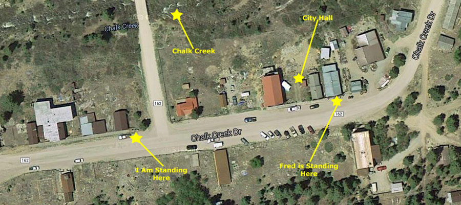
Even though St. Elmo is considered a ghost town it is still inhabited, and many tourists (like us) visit the town every year. The old mining roads are now used as Jeep and four-wheeler trails, and there are also many good places to fish along Chalk Creek, which runs through the town. The general store (Fred is standing in front of it in one of the pictures above) is open during the summer, when tourists can rent four-wheelers or buy items. When we visited, many of the buildings were still intact (you can see most of them in the picture of me above). Sadly, four of those buildings you can see in the picture burned down in 2002. The Buena Vista Heritage Association is rebuilding the town hall to its original state. But you can see where it was (and where our pictures were taken, on the recent aerial view below:
 |
We left St. Elmo about three-thirty in the afternoon for the hundred-mile trip to Canon City where we would spend the night.
|
We ate dinner at a local restaurant and walked around town for a while before turning in. Tomorrow, we will spend the morning at Royal Gorge.
Royal Gorge (7/26)
|
Before European settlement, Native Americans of the Ute people wintered in Royal Gorge for its protection from wind and relatively mild climate, and members of Spanish conquistador expeditions of the 17th century or fur traders may have seen Royal Gorge in their traversal of the area. The first recorded instance of a European arrival, however, is the Pike expedition of 1806. Zebulon Pike's group built a crude shelter in the gorge and explored the area, descending on horseback over the frozen Arkansas River.
Nearby Cañon City was founded in 1860, but it was the discovery of silver and lead near Leadville that prompted a race to build rail access to the area. While I would have thought that it would be easier to build a rail line up on the plateau above the gorge, railroads competed to use the bottom of the gorge itself for their tracks.
|
The first trains passed through the gorge in 1879 after the years of court battles between the two railroads were concluded, and freight and passenger service continued for some years. Freight service declined when other, less-costly routes were opened.
In the 1890s Royal Gorge was used as a passenger route for transcontinental rail travel. As many as four trains per day went through the gorge, though in time the establishment of alternate routes through the mountains made the Royal Gorge fall from favor for transcontinental use, and passenger train service on the main line was discontinued in 1967. The Royal Gorge Route Railroad now operates excursion trains through the Royal Gorge throughout the year. The train travels 12-miles through the canyon from Cañon City, Colorado to Parkdale and return.
Looking down into the gorge, you can easily see the railway tracks that were laid in the nineteenth century, and used up until the latter half of the twentieth. Though we did not see one, there are excursion trains that still use those tracks. Click on the thumbnail images below for some other views of the railroad right-of-way down in the gorge:
 |
With the decline in business use of the railway line through Royal Gorge, Cañon City found that it, too, was in decline, and the city looked for ways to halt the slide. The city got the idea to maximize the tourist use of Royal Gorge, extending the use beyond just the tourist trains that ran through the bottom.
|
The bridge was not constructed for transportation purposes; instead, it was built with the intent that it serve as a tourist attraction, and has continued to be one of the most-visited tourist attractions in Colorado since its construction. In fact, a road had to be built to get to the bridge and go a short ways across it; this road is designated as Fremont County Road 3A. The Royal Gorge Route Railroad runs under the bridge along the base of Royal Gorge.
Click on the thumbnail images below for some more views of the bridge that we took- some from the north side and some from the south:
 |
At 955 feet above the river, the bridge held the record of highest bridge in the world until 2001, when it was surpassed by a brige built in China (that is 1200 feet above the floor of the gorge below it).
|

|
The aerial tram was built in 1968, and many of the other attractions were built in the years immediately following the construction of the bridge. But most of the attractions that are there now (or were there in 2013), including the carousel, Old West town, petting zoo, the Royal Rush Skycoaster and the Soaring Eagle Zip Line, were built after our visit.
Sadly, a wildfire devastated the entire park in 2013. While the bridge suffered only minimal damage (some wooden deck planks burned), all but four of the park's 52 buildings were destroyed. The Incline Railway was severely damaged and the Aerial Tram was destroyed. Intentions are to completely rebuild the park.
|
Another neat thing to do is (was) to take the funicular down to the river itself. Like most funiculars, there are two cars; one is coming up while the other is going down, and the weight of each is used to propel the other. The cars had a wire mesh so no one could fall out, and it got in the way of my picture from our car. I took the picture when we were about two-thirds of the way down, and you can see that view here.
Once the car got to the bottom, we walked out onto the platform and then down some stairs to a walkway that led along the river for a few hundred feet.
|
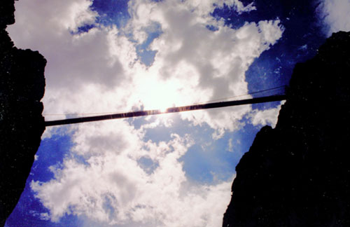
The walkway did not take you directly under the bridge, but I got as close as I could, aimed the camera up at the underside of the bridge, and took the photo below:
 |
When we had finished seeing what we could from the bottom of the gorge, we took the next car back up to the top, walked around and out onto the bridge one more time, and then, about noon, got into the truck and headed off for home.
The Trip Home (7/26)
|
Two hours later we were getting off I-25 in Raton, New Mexico, and onto US Highway 87 southeast back towards Amarillo, where we found ourselves about three and half hours later- about 4PM. There, we took I-40 east for just a few miles, exiting onto US Highway 287 headed southeast.
Another three hours found us in Wichita Falls where we stopped for a Mexican meal at a place we'd eaten a few times before. Then, about 8PM, we began the last leg home- 20 more miles on US 287 to US Highway 82 and then a three hour run straight east and over to Sherman, Texas. From there, we just had a short jog down US Highway 75 to Van Alstyne. We found ourselves back at Fred's house just about midnight.
This trip to Colorado was another great one, and we'd noted some places we wanted to return to on an upcoming trip.
You can use the links below to continue to another photo album page.
 |
August 7-9, 1998: The Texas Folklife Festival in San Antonio |
 |
July 21-26, 1998: Summer Trip to Colorado (Page One) |
 |
Return to the Index for 1998 |