


 |
July 21-26, 1998: Summer Trip to Colorado (Page Two) |
 |
July 14-16, 1998: My Sister Judy Visits Dallas |
 |
Return to the Index for 1998 |
For our summer trip this year, Fred has planned an outing to Colorado. He is trying to get the most out of his vacation time, so we will plan on using only three weekdays- leaving after work on Tuesday, July 21st, and returning home late on the evening of Sunday, July 26th. The high points of the trip will be visits to the headwaters of the Rio Grande in southern Colorado, camping at the Black Canyon of the Gunnison National Park in central Colorado and a stop at Royal Gorge in the southeastern part of the state. There will be lots of other stops as well.
Each segment of our summer trip will get its own section below. I hope you enjoy coming along with us!
NOTE:
This album page turned out to be pretty long, so to keep the page load time down to something reasonable, I am going to break this trip into two pages. When you get to the bottom of this page, just follow the link to the second one.
Traveling to River Hill Campground
The Headwaters of the Rio Grande (7/21-22)
|
Of course, if we are to be heading as far as Yellowstone in that direction, it makes much more sense to fly and rent a car. We have done that before, and have some trips on the drawing boards where we will do that again.
This time, though, we followed our typical route- from Van Alstyne up US 75 to Sherman, where we turn west on US 82 all the way to Wichita Falls. Depending on when we leave Fred's house, we usually have dinner as close to Wichita Falls as we can.
From Wichita Falls, we pick up US 287 and take that all the way to Amarillo, where we usually arrive about midnight- spending the night there. While Highway 287 is not Interstate, it is a divided highway most of the time, and you can move along fairly quickly.
|
We go right on through Dalhart onto a pretty desolate, 125-mile stretch of US 87 that takes us to Raton, New Mexico. (We actually cross into New Mexico about fifty miles northwest of Dalhart. Raton is on I-25, which runs north-south from Las Cruces in Southern New Mexico to I-90 in central Wyoming. Today, we will only take it north as far as Walsenburg, Colorado, where we will leave the Interstate and take US Highway 160 west to Alamosa and beyond.
We stopped just north of Raton at a rest area on I-25 to make ourselves lunch, and then continued on to Walsenburg and Alamosa.
|
About 50 miles west of Del Norte, we found the turn onto Colorado Highway 149 towards Creede, and from here the scenery gets exponentially better as the road rises and the upper stretches of the Rio Grande River come into view. About thirty miles along this highway and you begin paralleling the river, so there is always nice scenery to look at.
After about 45 miles of scenic mountain driving, we are about ten miles past Creede, where we begin to look for the National Forest signs that will indicate the turnoff to the campground for tonight. This turnoff actually came at the point where the river continues west but the highway heads north.
|
Then we saw the signs for the campground. River Hill Campground is located at an elevation of 9,250 feet. The campground is situated in a meadow surrounded by willows and spruce trees on the banks of the Rio Grande River. Campers come here to fish for trout, hunt, and enjoy the beautiful views of the forested hills and rock bluffs. There were a couple of separate sections to the campground, and we picked the smallest, furthest in section to get as much privacy as we could.
We had arrived just as the light was beginning to fade- about seven in the evening. This was the perfect time to get a campsite, set up the tent, and have supper before it really got dark- and that's just what we did. We did walk down to the Rio Grande, which is quite a beautiful mountain stream at this point, before turning in, but the real hiking and sightseeing would have to wait until tomorrow.
As it turned out, we got just the privacy and quiet that we wanted. While the other six or eight sites in our section were mostly full, people were quiet, and we drifted off to sleep to the sounds of the tumbling waters of the Rio Grande River not fifty feet from our tent.
Hiking Above the River Hill Campground (7/23)
|
In 1874 a Brewster Stage Line swing station was located here- mostly because of the long valley and access to good water. The main section of the campground features a campfire interpretive program on some weekend nights. We were fortunate, I guess, to have gotten a good campsite, for this is a popular campground which remains mostly full from mid-June through August.
From this campground, there is trail access to the Continental Divide and Weminuche Wilderness trails, Weminuche Creek Trail 818 and Squaw Creek Trail 814. We did not intend to do a lengthy hike today, but we did want to get up into the hills north of the campground to get good views of the surrounding San Juan Mountains. There were a number of short one- and two-hour hikes that were marked on the information board at the campground, and we picked up a trail guide and set out on one of them.
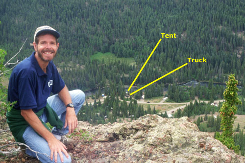
Before we look at all the pictures from our hike, though, I want to show you one of them- a picture Fred took of me with the campground below us in the background. To the right of that picture, is a more recent aerial photograph of the same campground:
 |
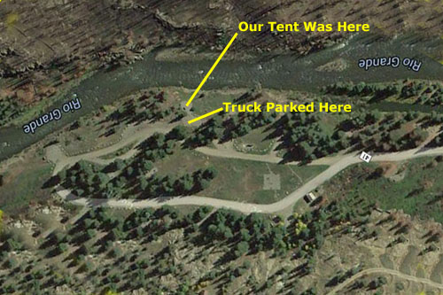 |
I just thought it was immensely interesting to compare the picture we took in July, 1998, with the aerial view that was taken sometime around 2010. One thing you notice is that many of the trees in our picture are missing in the aerial view. Indeed, there was a fire in this area between the time we visited and now, and I presume that is why many of the trees, both around the campsites and across the river to the south, are gone.
|
The trail slanted up along the mountainside, but there were sections where it was difficult to determine where the trail actually was, and I guess we must have just gone cross-country at some points. As we ascended, the views got better and better. Click on the thumbnail images below to see some of them:
 |
After a while, we realized that we'd totally lost the trail, but that didn't matter. Since we were on a south-sloping hillside north of the campground, the valley and campground where almost always visible, and so it was basically impossible to get lost. We enjoyed clambering across the mountainside, setting up the tripod and taking pictures.
Fred found a lot of interesting plants and some totally unknown mountain wildflowers.
I think we must have spent the better part of two hours enjoying the mountain morning and hiking across the mountainside.
|
If you would like to see some more of the wonderful views from our hike this morning, just click on the thumbnail images below:

|
We were really enjoying the hike, although in the warming morning and with the exertion of climbing, both Fred and I had to shed a layer, but eventually decided to head on back down the hillside to the campground where we struck the tent (which we had left to completely dry in the morning sun), clean up the campsite and pack up to head out.
As we got the campsite packed up, both Fred and I changed clothes, since we hiked this morning in the same ones we'd been wearing since we left Van Alstyne two days previously.
The Headwaters of the Rio Grande (7/23)
|
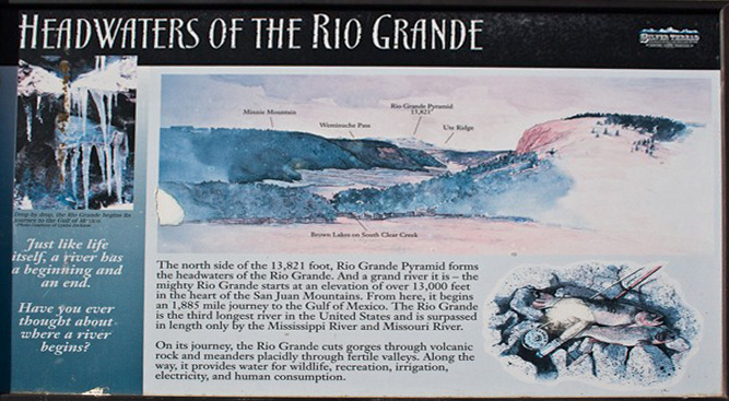 |
We stopped to read the sign above and look out across the Brown Lakes and the verdant, swampy valley beyond them. This area is part of a larger area that is the initial watershed for the Rio Grande. The headwaters of the river encompass other areas as well, but the area we were looking at is defined to be the initial area of drainage.
|
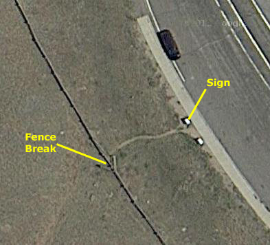 |
Take a look at the picture of me, and notice that there was a vee-shaped pass-through in the stock fence behind me in the picture (stock can't figure out how to get through the opening, but of course people can). Now look at the aerial view. In case you might miss it, I've marked that exact same fence break. Now, we were here in 1998- sixteen years before I am writing this. But the fence is, apparently, exactly the same now as it was then (Google aerial views are typically no more than a few years old).
|
We took a number of really nice pictures of the Brown Lakes and the Rio Grande headwaters, and you can click on the thumbnail images below to have a look at them:
 |
After taking our pictures, we went back out to Highway 149 to continue north.
North Clear Creek Falls (7/23)
|
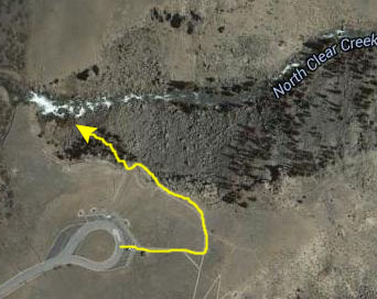 |
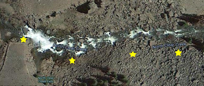
North Clear Creek Falls is an impressive drop of a little over 100 feet and is believed to be the most photographed waterfall in Colorado. There's a viewing area from which you can see it, and if you want, there's a little trail you can follow along the edge of the canyon. It gives you different viewpoints of the falls. You can also climb out on to the rocks of the west face of the little canyon, and you can get right up close , but it's a pretty long ways down, so we had to be careful to watch our step. This waterfall is considered to be the most photographed of all waterfalls in Colorado, but you need to be careful when you're taking pictures because some of the rocks can be slick.
|
 |
|
Fred got one other neat picture that I want to include here- a closeup of some ferns and orange lichens on one of the rocks we passed.
The Black Canyon of the Gunnison (7/23-7/24)
|
The highway took us north along the eastern edge of the Uncompahgre Wilderness (formally called the Big Blue Wilderness)- a 100,000-acre U.S. Wilderness Area and National Forest. Elevation in the Wilderness ranges from 8,400 feet (our highway was at an elevation of just over 7,500 feet) to 14,309 feet at the summit of Uncompahgre Peak.
Managed by the Uncompahgre National Forest, it is located approximately 5 miles northwest of the town of Lake City and some 10 miles east of the town of Ouray. The area is named for Uncompahgre Peak, which at 14,309 feet is the highest peak in the San Juan Mountains. The Wilderness includes one other prominent fourteener, Wetterhorn Peak at 14,015 feet.
Then Highway 149 turned a bit northeast and came around the eastern shore of the Blue Mesa Reservoir on the Gunnison River to intersect with US Highway 50. The Gunnison River is flowing east at that point, after it comes down from the north and the Black Canyon of the Gunnison. We then headed west along the northern edge of that reservoir, crossing it twice, and then generally continued west following the river until it curved away to the north while we headed west towards Montrose.
We looked for the signs to the National Park, and turned north on Colorado Highway 347 which took us into the National Park where we stopped so I could get a picture of Fred just inside the National Park. Our first objective was to secure a campsite, and so we turned into the first campground we found- the South Rim Campground. It was already filling up, even though this was a weekday, but we found a nice site near the canyon in the northernmost loop.
It was getting late in the afternoon, so we didn't plan on doing much sightseeing today. We just set up the tent and stuff, Fred fixed some supper and we attended a Ranger presentation before turning in.
|
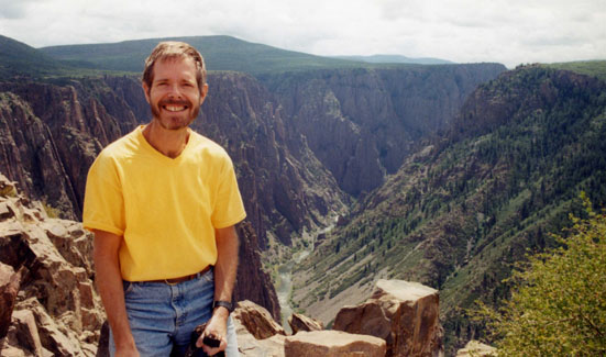 |
The Ute Indians had known the canyon to exist for a long time before the first Europeans saw it. By 1776 two Spanish expeditions had passed by the canyons, and in the 1800s, fur trappers knew of it. The first official account was in the journals of Captain John Gunnison in 1853, who was surveying a route from Saint Louis to San Francisco- "the roughest, most hilly and most cut up." Following his death at the hands of Ute Indians later that year, the river was named in his honor.
|
There were hopes of continuing the railway through the part of the canyon now inside the national park, but the railway's top engineer declared it to be impenetrable. Instead, the line ran south of the canyon to Salt Lake City.
Visitors came to see the canyon as an opportunity for recreation and personal enjoyment. Rudyard Kipling described his 1889 ride through the canyon in the following words: "We entered a gorge, remote from the sun, where the rocks were two thousand feet sheer, and where a rock splintered river roared and howled ten feet below a track which seemed to have been built on the simple principle of dropping miscellaneous dirt into the river and pinning a few rails a-top. There was a glory and a wonder and a mystery about the mad ride, which I felt keenly." By 1890, an alternate route through Glenwood Springs had been completed and the route through the Black Canyon, being more difficult to operate, lost importance for through trains. The route was finally abandoned in 1955.
In 1905, work began on a water diversion tunnel to bring water to the Uncompahgre Valley, which was suffering from water shortages due to an influx of settlers into the area. The difficult, exhausting and dangerous engineering feat was completed in 1909, at the cost of over $76 million (in today's dollars) and 26 lives. The 5.8-mile tunnel was, at the time, the world's longest irrigation tunnel. The Black Canyon of the Gunnison was established as a U.S. National Monument on March 2, 1933. It became a National Park the year after our visit.
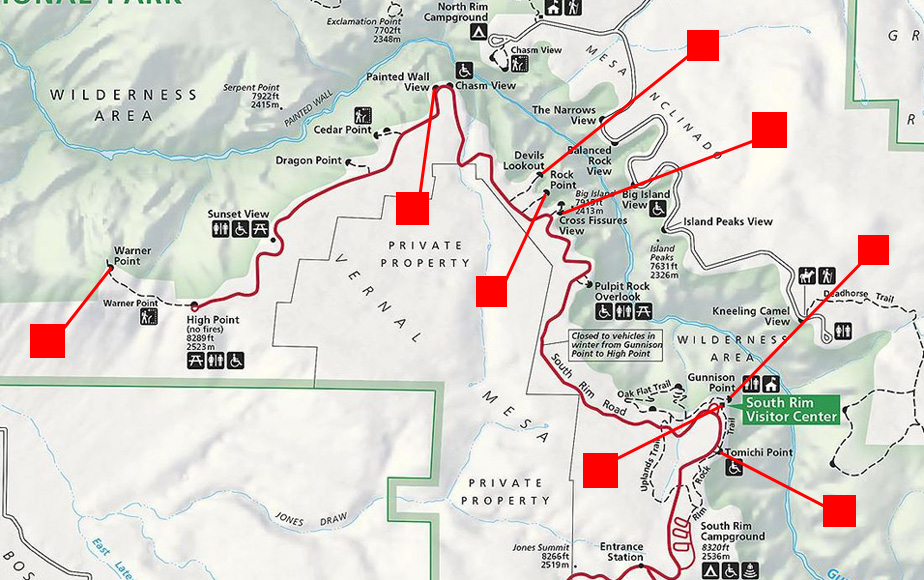
After we broke camp in the morning, we headed north towards the Visitor Center, stopping there before continuing on all the way to Warner Point at the north end of the road. On the way, we stopped at just about every overlook and viewpoint, taking pictures at many of them. So that you can follow along with us, I have noted on the park map below where we stopped for a picture (the red squares). To see the picture we took at that spot, just click on the red square connected to it.
 |
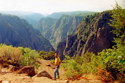
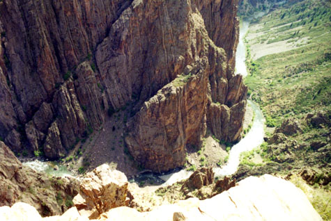
The drive along the South Rim Road was a real treat; the views were uniformly amazing. Below are the last two pictures we took here in the Black Canyon of the Gunnison National Park:
 |
 |
The North Fork of the Gunnison (7/24)
|
We would continue on east on Highway 92 until that highway began heading southeast (to rejoin US Highway 50 a good ways east of the National Park. At that point we headed northeast on Colorado Highway 133. This road would take us further north and east very near the northern boundary of the Gunnison National Forest and, for a stretch, alongside the North Fork of the Gunnison River.
Since leaving the National Park, we had been driving through relatively level farmland, although this farmland is well over a mile high. As we came around the top of Gunnison Gorge, the road ascended for a time so that as we drove, we had views out to the left looking down at the verdant farmland and views out the right at Gunnison Gorge.
|
As I said, on the other side of the highway we could see the beginnings of Gunnison Gorge, which heads off to the south, quickly deepening to become the Black Canyon of the Gunnison.
The views of the gorge were also very beautiful, as were the views of the mountains ahead of us. If you would like to see some of the pictures we took of the gorge and of the mountains, just click on the thumbnail images below:

|
The highway descended again into relatively flat country, although the mountains all around us were always visible. After we turned off on Colorado 133, though, the road began ascending again into the mountains- although nothing spectacularly high. Eventually, we noticed that the highway was paralleling a river- the North Fork of the Gunnison.
|
As it turned out, this portion of the Gunnison is a favorite for kayakers; we passed a couple of outfitters that rent kayaks for folks to use to go downriver. It looked like fun, but only if you know what you are doing. Click on the thumbnail images below to see some views of the North Fork of the Gunnison that we took as we drove, when we stopped, or when we walked down to the river itself:
 |
The other thing that's neat is the sound the water makes. In the cool air we drove with the windows open, and the sound of rushing water was constantly with us. It is hard to describe how much this adds to the drive; as I said, you have a treat in store if you haven't driven a highway like this before. We stopped continually to walk down to the river or to take pictures. Click on the thumbnail images below to see the last of the pictures we took along the North Fork of the Gunnison:
 |
To implement our plan of getting over to the far side of the Sawatch Range, we had to get a good deal east, and the best way to do that would be to head up to I-70 and take that east.
|
We headed east on I-70, unquestionably one of the nation's most beautiful stretches of Interstate Highway. Taking pictures from the truck couldn't do the cantilevered highway justice as it went through multiple tunnels and paralleled the Colorado River. Again, we thought that we'd need to come back here one day when there would be time to either hike or bike on the trails we could see below or beside us. We continued east, passing one turnoff for Leadville (US 24) because we did not want to drive there in the dark.
Instead, we went on to the next major town- Silverthorne. (We thought about stopping in Vail, but thought that everything there would be expensive.) In Silverthorne, we checked into a very nice motel called The Silver Inn, went out for a good supper, and turned in.
To continue with us on our Colorado Trip, just click on the "Page Two" link below. You can also use the other links to navigate elsewhere in the album.
 |
July 21-26, 1998: Summer Trip to Colorado (Page Two) |
 |
July 14-16, 1998: My Sister Judy Visits Dallas |
 |
Return to the Index for 1998 |