|
September 13-16, 1976: A Sales Trip to Seattle |
|
June 12-14, 1976: A Drive to Reno, Lake Tahoe, and Yosemite |
|
Return to Index for 1976 |
In the Fall, I did some training in Maryland, outside Washington, and stayed over on Saturday to tour the city with my camera. I was staying in Bethesda, northwest of the city, so I just drove in, found a place south of Constitution Avenue to park my car, and then spent most of the day walking around the area around the National Mall.
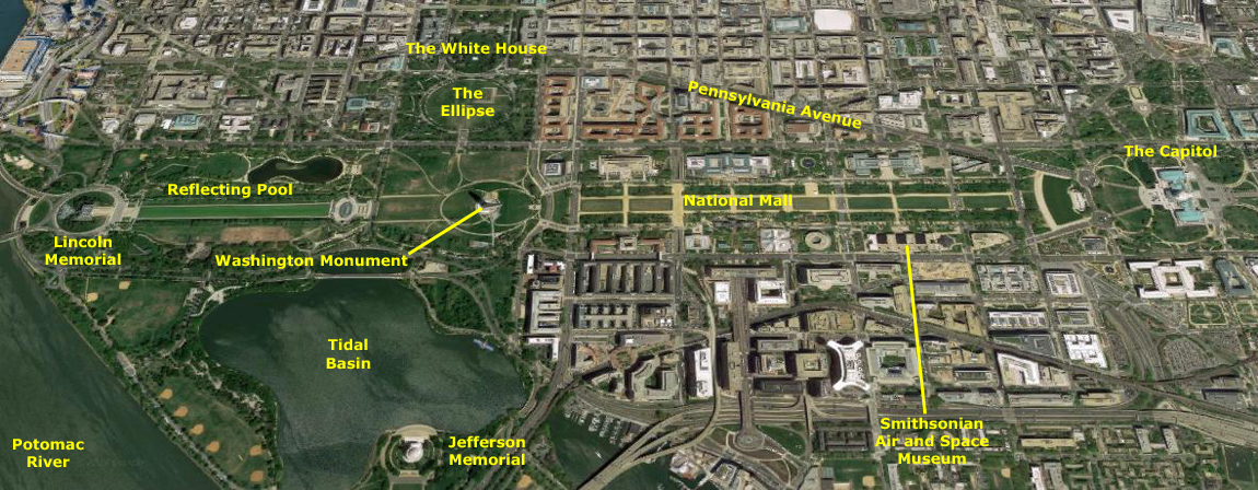 |
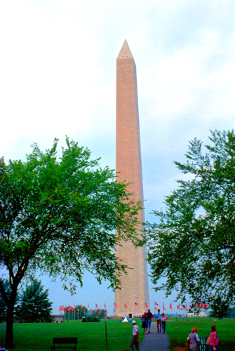
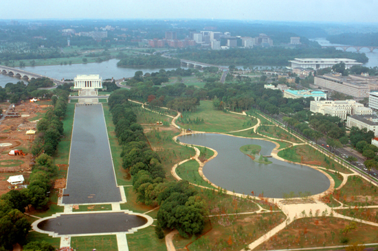
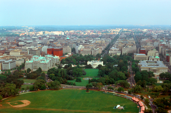
The aerial view above covers the area that I walked, and I have marked most of the stops I made, which will enable you to orient yourself and the pictures that I took today. My first stop, simply because there is usually a line to go up in it, was the Washington Monument.
|
The Washington Monument is the obelisk built to commemorate George Washington, once commander-in-chief of the Continental Army and the first President of the United States. Located almost due east of the Reflecting Pool and the Lincoln Memorial, the monument, made of marble, granite, and bluestone gneiss, is both the world's tallest predominantly stone structure and the world's tallest obelisk, standing 555 feet tall. It is the tallest monumental column in the world if all are measured above their pedestrian entrances. It was the tallest structure in the world from 1884 to 1889, when it was overtaken by the Eiffel Tower in Paris.
Construction of the monument began in 1848 and was halted from 1854 to 1877 due to a lack of funds, a struggle for control over the Washington National Monument Society, and the intervention of the American Civil War. Although the stone structure was completed in 1884, internal ironwork, the knoll, and other finishing touches were not completed until 1888. A difference in shading of the marble, visible approximately 150 feet (46 m) or 27% up, shows where construction was halted and later resumed with marble from a different source.
The Washington Monument is a hollow Egyptian style stone obelisk with a 500-foot tall column and a 55-foot pyramidion. Its walls are 15 feet thick at its base and 18 inches thick at their top. The marble pyramidion has thin walls only 7 inches thick supported by six arches, two between opposite walls that cross at the center of the pyramidion and four smaller corner arches. The top of the pyramidion is a large marble capstone with a small aluminum pyramid at its apex with inscriptions on all four sides.
The interior is occupied by iron stairs that spiral up the walls, with an elevator in the center, each supported by four iron columns, which do not support the stone structure. The stairs contain fifty sections, most on the north and south walls, with many long landings stretching between them along the east and west walls. These landings allowed many inscribed memorial stones of various materials and sizes to be easily viewed while the stairs were accessible (until late this year), plus one memorial stone between stairs that is difficult to view. I had climbed the stairs once before in my life, and wanted to do so again before they were closed (as the closing had been announced earlier in the year.
|
The Lincoln Memorial Reflecting Pool was designed by Henry Bacon, and was constructed in 1922 and 1923, following the dedication of the Lincoln Memorial. It is approximately 2,000 feet by 170 feet- about four-fifths of a mile around. It is only a foot and a half deep at the sides to about two and a half feet deep in the center, holding some 7 million gallons. Depending on the viewer's vantage point, it dramatically reflects the Washington Monument, the Lincoln Memorial, the Mall's trees, and/or the expansive sky.
The Lincoln Memorial is at the western end of the pool; it was dedicated in May, 1922. It has always been a major tourist attraction and since the 1930s has been a symbolic center focused on race relations. The building is in the form of a Greek Doric temple and contains a large seated sculpture of Abraham Lincoln and inscriptions of two well-known speeches by Lincoln, The Gettysburg Address and his second inaugural address. The memorial has been the site of many famous speeches, including Martin Luther King Jr.'s "I Have a Dream" speech, delivered on August 28, 1963, during the rally at the end of the March on Washington for Jobs and Freedom. Like other monuments on the National Mall, the Lincoln Memorial is administered by the National Park Service. It has been listed on the National Register of Historic Places since 1966 and is open to the public 24 hours a day- visited by some 5 million people a year.
To the right of the Reflecting Pool in my picture is the newest of our National Parks- Constitution Gardens- which opened only earlier this year. The 50-acre park is on the site of former World War I buildings; these were demolished in 1970, and then President Nixon signed an executive order to establish a public park on the land. The park was opened as part of the nation's bicentennial celebrations a couple of months ago.
|
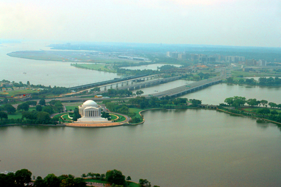
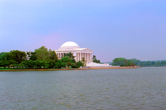
The Jefferson Memorial is dedicated to Thomas Jefferson (1743–1826), one of the most important of the American Founding Fathers as the main drafter and writer of the Declaration of Independence, member of the Continental Congress, governor of the newly independent Commonwealth of Virginia, American minister to King Louis XVI, and the Kingdom of France, first U.S. Secretary of State under the first President George Washington, the second Vice President of the United States under second President John Adams, and also the third President (1801–1809), as well as being the founder of the University of Virginia at Charlottesville, Virginia.
Construction of the neoclassical Memorial building began in 1939 and was completed in 1943. The bronze statue of Jefferson was added in 1947. The building's designer made references to the Roman Pantheon and Jefferson's own design for the Rotunda at the University of Virginia. The Jefferson Memorial, and the White House located directly north, form one of the main anchor points in the area of the National Mall. (The Washington Monument was supposed to be directly between the two, but soft swampy ground which defied 19th century engineering required it be sited somewhat to the east.
|
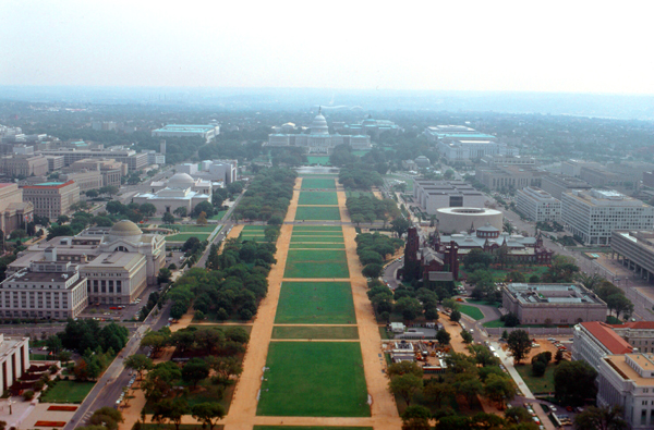
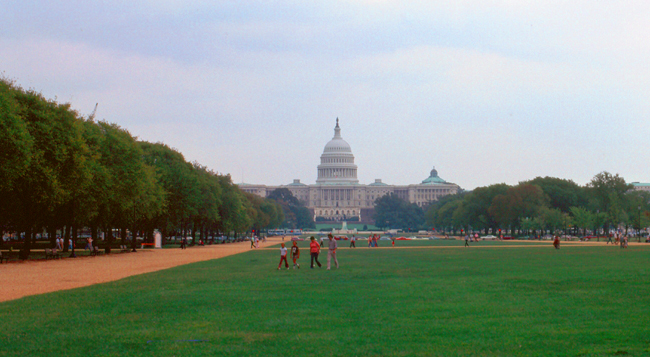
The National Mall is bordered by (or contains, depending on how the term is used) a number of museums of the Smithsonian Institution, art galleries, cultural institutions, and various memorials, sculptures, and statues. The park receives approximately 24 million visitors each year. In my picture, clockwise from the near left, are a corner of the Smithsonian Museum of American History, the Smithsonian Museum of Natural History, the National Gallery of Art and its Sculpture Garden, the U.S. Capitol (and the other end of the Mall), the National Museum of the American Indian, the Smithsonian National Air and Space Museum, the round Hirschorn Museum, the complex that includes the Smithsonian Arts and Industries Museum, Smithsonian Castle, and the Sackler Gallery, and, finally, one of the buildings of the Department of Agriculture.
In his 1791 plan for the future city of Washington, D.C., Pierre Charles L'Enfant envisioned a garden-lined "grand avenue" approximately 1 mile in length and 400 feet wide, in an area that would lie between the Congress House (now the Capitol Building) and an equestrian statue of George Washington. The statue would be placed directly south of the President's House (now the White House), on the site now occupied by the Washington Monument. The "grand avenue" was never built, and the area instead became what most people think of as the National Mall.
|
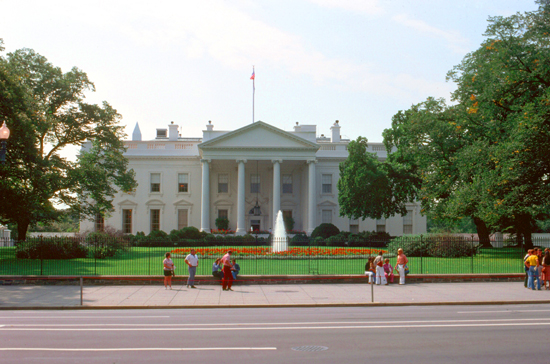
The Ellipse is a 52-acre park, although the term properly refers to the five-furlong circumference street within the park. The entire park, which features various monuments, is open to the public and is the location for a number of annual events. The Eisenhower Executive Office Building (EEOB) is the structure in which the Executive Office of the President is located (the Oval Office being the President's official and ceremonial office); the Office of the Vice President of the United States is also located here. The building was commissioned by President Ulysses S. Grant and built between 1871 and 1888. On the opposite side of the White House is the Treasury Building, the latest in a series of buildings and building modifications across 15th Street from the White House. An image of the building, built in stages from 1838 to 1860, is on the reverse of the United States ten-dollar bill.
The most iconic structure in the view, though, is the White House itself- the official residence and workplace of every President of the United States since John Adams in 1800. The neoclassical structure was designed by James Hoban, modeled on the Irish Legislature building in Dublin, and built between 1792 and 1800 using Aquia Creek sandstone painted white. The building's modern appearance dates to its reconstruction after being burned by the British Army during the War of 1812; President James Monroe moved back into the partially reconstructed Executive Residence in October 1817, the south portico was added in 1824 and the north portico in 1829.
|
Today's White House is much different in appearance from the original. Overcrowding led President Theodore Roosevelt to have all work offices relocated to a newly constructed West Wing in 1901. Eight years later, President Taft expanded the West Wing and created the first Oval Office. The third-floor attic of the main house was converted to living quarters in 1927, when the dormers that you can see in my picture were added. A new East Wing was constructed in 1946 to add more office space. In 1948, an engineering report reveled the building's internal walls and wood beam frame to be close to failure, so President Truman presided over a major renovation during which the interior rooms were completely dismantled, a new load-bearing steel frame installed, and the rooms rebuilt.
Out of respect for the historic character of the White House, no substantive architectural changes have been made to the house since the Truman renovation. Congress enacted legislation in 1961 declaring the White House a museum. Furniture, fixtures, and decorative arts could now be declared either historic or of artistic interest by the president. This prevented them from being sold (as many objects in the executive mansion had been in the previous 150 years). When not in use or display at the White House, these items were to be turned over to the Smithsonian Institution for preservation, study, storage, or exhibition.
Since the Kennedy restoration, every presidential family has made some changes to the private quarters of the White House, but the Committee for the Preservation of the White House must approve any modifications to the State Rooms. Charged with maintaining the historical integrity of the White House, the congressionally authorized committee works with each First Family—usually represented by the first lady, the White House curator, and the chief usher—to implement the family's proposals for altering the house.
|
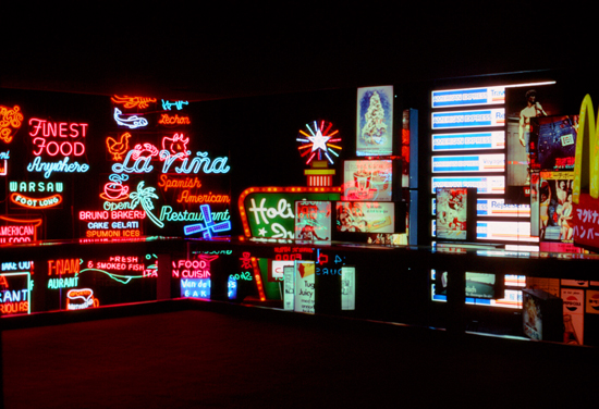
The Museum of History and Technology (part of the Smithsonian Institution) collects, preserves, and displays the heritage of the United States in the areas of social, political, cultural, scientific, and military history. Among the items on display is the original Star-Spangled Banner. The museum opened in 1964.
Photography was allowed, but there was so much to see that I absolutely could not decide what was worth a picture- at least not until I got to an exhibit connected to the Bicentennial celebration; that exhibit was called "A Nation of Nations". Looking for a way to illustrate the multicultural infouences that made up 20th-century America, museum curator had hit on the idea of using neon signs. They traveled around the country collecting original signs (and in many cases offering to replace the originals with new copies). They brought them back to the museum and created two rooms full of them, and at right is my picture of one of those rooms.
One museum that I really wanted to see was the newest one on the Mall, one that opened just this year= the National Air and Space Museum. I'd already heard a good deal about it, and I wanted to spend the bulk of my museum time there. So I left the history museum via its Mall-side entrance and took the first cross-mall walkway I could find directly over to the Air and Space Museum, going around to Constitution Avenue and its main entrance.
|
The history of the building begins with President George Washington (along with eight other Freemasons all dressed in masonic regalia, if you are interested in that sort of thing) laying its cornerstone in 1793. The Senate wing was completed in 1800, but the House had to share temporary quarters until its own wing was completed in 1811. At that time, a covered wooden temporary walkway connected the two wings with the Congressional chambers where the future center section with rotunda and dome would eventually be. The Capitol was partially burned by the British on August 24, 1814, but reconstruction began in 1815 and included redesigned chambers for both Senate and House sides, which were completed by 1819. Construction continued through to 1826, with the addition of the center section with front steps and columned portico and an interior Rotunda, rising above the first low dome of the Capitol.
By 1850, an expansion became necessary, and two new wings were added – a new chamber for the House of Representatives on the south side, and a new chamber for the Senate on the north; African Americans, some free and some enslaved, composed the majority of the workforce. The 1850 expansion more than doubled the length of the Capitol, and dwarfed the original dome, and so in 1855 it was torn down and replaced with the "wedding-cake style", 4500-ton cast-iron dome that stands today. Renovations in 1904 and 1960, and an expansion in 1958 have resulted in the building that is in use today.
Like the principal buildings of the executive and judicial branches, the Capitol is built in a distinctive neoclassical style and has a white exterior. Both its east and west elevations are formally referred to as fronts (you are looking at the West Front in my picture), though only the east front was intended for the reception of visitors and dignitaries. Even so, in movies and television shows, it is the West Front (or a copy) that is more often used filming.
|
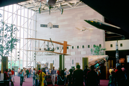
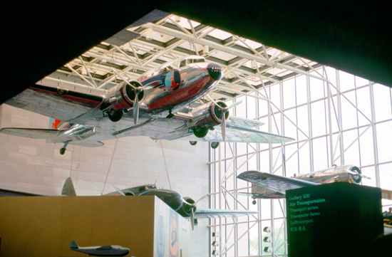
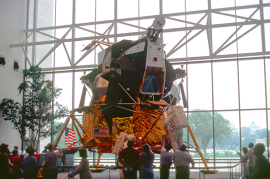
The National Air and Space Museum is a center for research into the history and science of aviation and spaceflight, as well as planetary science and terrestrial geology and geophysics. Almost all space and aircraft on display are originals or the original backup craft.
This was my first visit to this new museum, but I have been back numerous times, and it is now my favorite place in Washington. There are all kinds of interesting exhibits of just about everything connected with flight, including the Spirit of St. Louis, the Apollo command module that landed on the Moon, an X-15 aircraft, and numerous other craft from DC 3s to spacecraft. There is also a dynamite movie, called "To Fly" which is shown on a three-story screen. The movie is so realistic that the audience actually feels a part of the action. There are a couple of sequences where the movie shows a pilot's-eye view of flight, and the audience visibly leans to one side as the plane banks. There are also some extraordinary pictures of planes in flight, taken from other planes flying alongside.
|
|
| NOTE: Actually, you're in luck. When I commented that the movie might be available online now, in 2019, I was right. So, using technology that would have been magical enough to have had me locked up had I shown to anyone in the museum today, I've been able to download a copy of the very movie I watched, so you can watch it to. Use the player at right to do so; I think you will find it interesting. (And no, not many movies were widescreen back then!) |
Wandering around the Air and Space Museum today, I certainly could have taken a lot of pictures, and if film and print costs weren't so high, I might have done so. I did take a couple of others though, and here they are:
|
|
I spent quite a bit of time in the Air and Space Museum; it was really incredible. Late in the afternoon, I left the museum to walk around some more, and I found myself by the Tidal Basin and the Jefferson Memorial.
|
This site was well suited for another high-profile memorial since it sat directly south of the White House, but a 1901 commission couldn't decide who to honor or with what. In 1918, the water in the Tidal Basin began to be treated so it could be used for swimming, and there was a beach on the site of the future memorial until 1925. I that year, the design for a memorial to Theodore Roosevelt was proposed but never funded by Congress. Finally, in 1934, FDR, an admirer of Jefferson, suggested to the commission that a memorial to Jefferson be considered. The idea gained traction and the Congress eventually appropriated $3 million for it.
Actually, four different plans for different sites were proposed, the Tidal Basin being one of them. The Commission preferred the Tidal Basin site because of its prominence and the fact that it would completed the four-point plan for the Mall (White House to site, Lincoln Memorial to Capitol, Washington Monument in the center. The proposed design was for a pantheon-like structure, to sit on a square platform, and to be flanked by two smaller, rectangular, colonnaded buildings. Although outcry at the removal of the cherry trees Japan gave to the United States resulted in a smaller footprint, construction began in 1938 and the memorial was officially dedicated in 1943.
On Sunday morning, I took my rental car for a drive up into the valley of the Shenandoah to pay a short visit to Carter Fussell, who was a classmate of mine at Davidson. I didn't have a phone number for Carter, so I had to wait until I got to Front Royal so I could look in a phone book and call.
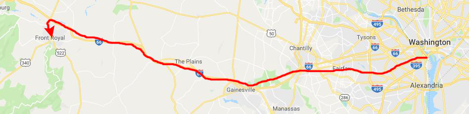 |
The route I followed was on-again, off-again freeway, mostly I-66 which is still under construction. Most of it was completed out west, but there were still sections closer in that were being built. Anyway, it was a nice drive and I got to Front Royal in about 90 minutes. There, I found a pay phone and looked up the Fussell's number and called. I got Carter's Mom, who told me that Carter was away, but that I should drop by their house anyway. This would be my second time in the Fussell home; I came up to his house with him one holiday from Davidson. I had a nice visit with his Mom, but was disappointed that Carter himself was in Philadelphia teaching.
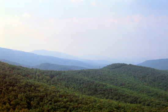
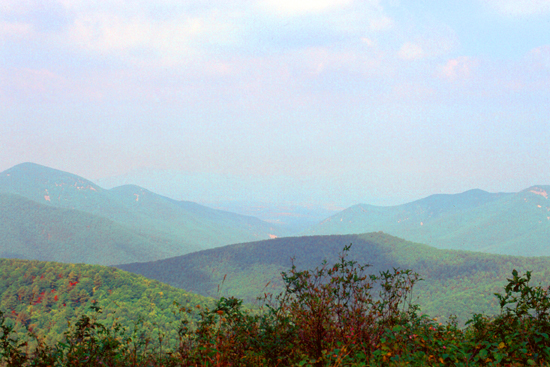
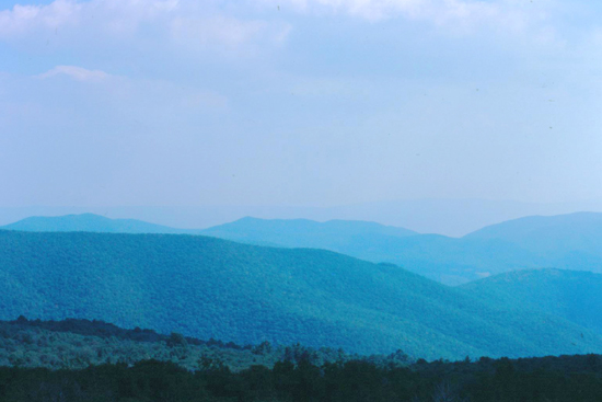
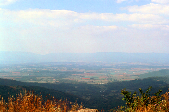
I took some pictures on my trip up into the Shenandoah, and here they are:
|
|
|
|
I enjoyed my weekend in Washington, and my visit with Mrs. Fussell. I drove back to Washington National Airport, and was back home in Chicago by 8PM.
You can use the links below to continue to another photo album page.
|
September 13-16, 1976: A Sales Trip to Seattle |
|
June 12-14, 1976: A Drive to Reno, Lake Tahoe, and Yosemite |
|
Return to Index for 1976 |