

 |
April 8, 2018: Marina Sands and The Gardens By the Bay |
 |
Return to the Index for Our Visit to Singapore |
We will leave the Ibis this afternooon about 2PM for the cruise port and our boarding the Royal Caribbean Mariner of the Seas for our cruise to Dubai. I have arranged for a late checkout, leaving us free to spend the morning wandering around the area between the Ibis and Marina Bay. There is more to do than we have time for, but we will try to see as much as we can before we have to leave.
Marina Bay
First of all, we needed to get down to Marina Bay from the Ibis on Bencoolen. I was not sure how long the walk would be, so I asked at the front desk, and found that an inexpensive, ten-minute bus ride would get us there.
|
As it turned out, we could have walked (which we did on the way back), but I was not sure of the route to get there, didn't want to make a wrong turn, and also thought that we shouldn't tire ourselves out in the warm morning just getting down to the Bay.
|
The last time I did, in Chicago, rows of seats began right at the front of the bus, I guess to maximize the passenger load. The interiors here seem more spacious, but, again, I may just not be familiar with public transit in the States much anymore.
The bus went right down Bencoolen and then turned left to head down a well-to-do street towards the Bay. We passed a tall monument on our right (we will see it on our walk back) and then turned just beyond it to head south again. Passing the monument, we came to what looked like a parade ground (odd, it seemed, so close to the center of town) and the bus turned in to a shaded street where numerous other public and private buses were stopped. It was here that we got off- right by that "parade ground".
|
Although we could look at the pictures pretty much in sequence, I think that what I'll do here is make sure that all our pictures of a given site- like the Victoria Theatre- are kept together, even though we passed the building a couple of times and took pictures each time.
Some of the things we took multiple pictures of- like the Merlion Fountain and the buildings of the downtown core- will get their own album sections this morning. So will some of the other locales that we took more than just a few pictures of.
Of course, we also took candid pictures as we were walking between one thing and another; unless some of these pictures belong in their own sections, I'll probably just include them in the section for the attraction that we were walking to or walking from.
The aerial view at right shows the attractions that we visited, and I have also sketched in the approximate path that we took walking around this morning.
With that bit of introduction, let's first head over to the Merlion Fountain- one of the city's most recognizable landmarks.
The Merlion Fountain
When we alit from the city bus, we could see the Bay off to our left, and we could see the Marina Bay Sands on the far side of it, so it was no problem to head in the right direction.
|
There were neat views from the bridge; prominent in the northeast skyline is the round tower of The Stamford Hotel, part of the Raffles Convention Center complex:
|
Due to the flourishing trade on the Singapore River by the 1880s, the old Cavenagh Bridge could not support the increasingly heavy traffic into town- hence the construction of the new bridge. The Cavenagh Bridge was converted to a pedestrian bridge. The elegant bridge has intricate plaster and is comprised of three steel arches with supporting steel ribs extending across them, two rusticated archways and a fluted pier at each end. Located near the Fullerton Hotel, the Anderson Bridge is still in service, connecting the financial district directly to City Hall.
|
|
The Esplanade Bridge is an 850-ft.-long road bridge that spans the mouth of the Singapore River; the Esplanade Theatres are on its northern abutment and the Merlion is on the southern. The 230-foot-wide concrete arched bridge has seven spans and supports eight traffic lanes.
When we came under the Esplanade Bridge, we found ourselves on the bayside plaza just north of the Merlion. From here, there were great views of the north side of Marina Bay- from the Convention Center past the Esplanade Theatres and then across the high-rise hotels and offices of Marina Square and The Promenade. There was also a walkway leading out into the Bay (so you could look at the Merlion from the front), and there were great pictures from there, too:
|
|
One more picture before we turn to the Merlion itself. Here is a nice panoramic view of the entire Marina Bay- all the way from the Convention Center to the north past the Marina Bay Sands on the east and around to the downtown core on the south:
|
As you can see from the aerial view above, there is a jetty that juts out into Marina Bay, and from that jetty you can see the Merlion from the front (since it faces the Bay). Here is the view of the Merlion from that jetty:
|
The fish body represents Singapore's origin as a fishing village, and the lion head represents Singapore's original name- Singapura- meaning "lion city". The symbol was designed in 1964 as the logo of the Singapore Tourism Board; although the logo changed in 1997, the symbol is still "trademarked".
While this statue and its fountain is the most-visited monument in the city, some critics (most of them from outside Singapore) rank it as "disappointing" (along with the "Little Mermaid" in Copenhagen and the "Manneken Pis" in Brussels).
|
|
The relocation took three full days. The meticulously-planned journey required one barge, two 500-ton cranes, and a team of 20 engineers and workers on site. The entire statue was hoisted onto the barge, which then sailed to the new installation site at the current Merlion Park, near the mouth of Singapore River. During the voyage, the statue had to be hoisted from the barge, over the Esplanade Bridge and then back onto the barge, as it was too tall to pass underneath.
Exactly 30 years after it was officially dedicated, Senior Minister Lee Kuan Yew returned from his retirement to once again welcome the Merlion Statue- this time to its "forever home". A viewing deck now stretches out into Marina Bay (technically still part of the Singapore River), allowing visitors to pose for a photograph with a front or side view of the Merlion, including a new city skyline backdrop for their pictures. We certainly took our share.
|
(Mouseover Image Above for Video Controls) |
Here are more good views of the Merlion from various vantage points:
|
We took lots of panoramic views of the Merlion and its surroundings; one of them shows the entirety of Marina Bay:
|
Singaporean poet and academic Edwin Thumboo cemented the iconic status of the Merlion as a personification of Singapore with his poem "Ulysses by the Merlion" in 1979. Due to Thumboo's status as Singapore's unofficial poet laureate and the nationalistic mythmaking qualities of his poetry, future generations of Singaporean poets have struggled with the symbol of the Merlion, frequently taking an ironical, critical, or even hostile stand – and pointing out its artificiality and the refusal of ordinary Singaporeans to accept a tourist attraction as their national icon. The controversity notwithstanding, you might want to read the poem. Below, left, is another good picture of Fred and I and the Merlion; below, right, is a scrollable window containing Thumboo's poem:
|
|
Before we leave the Merlion and head down to look at the downtown core, here is another nice panoramic picture that Fred took:
|
Singapore's Downtown Core
I had seen the term "Downtown Core" quite a few times yesterday and today, and all along I thought it was generic term, one that referred to the central part of the downtown of any particular city. Little did I know, until I started working on these pages, that "Downtown Core" actually refers specifically to the historical and downtown center of the city-state of Singapore.
|
|
I have discovered that over the years, as Singapore has grown, the Downtown Core has also expanded- notably to include the buildings at the left side of the picture and also some of the new structures behind those you can see in the picture.
As the financial Heart of Singapore, the Downtown Core houses the headquarters and offices of numerous corporations, as well as the Singapore Exchange. In recent years, on the fringes of the Core, residential towers and low- and mid-rise residences have been constructed; you can see some of these in the aerial view. Although the Core has expanded over the years, the one boundary element that seems not to have changed is the Singapore River. This puts the Fullerton Hotel in the Core, but the Victoria Theatre, Supreme Court, and some other governmental buildings are just outside it.
From the Merlion, we walked first southwest along the north shore of Marina Bay. This area has been entirely redeveloped, and is a beautiful promenade fronting on the Bay. There are a good many shops and restaurants that would cater to the tourist crowd as well as to office workers on the weekday.
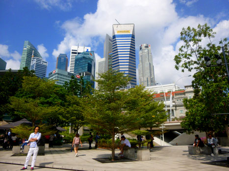 Looking Northwest from the Merlion |
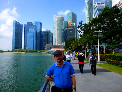 The Promenade Along Marina Bay |
Singapore's modern history began in this area, when Stamford Raffles and representatives of the British East India Company landed along the banks of the Singapore River to set up a free port in Southeast Asia. As the old harbour grew along the mouth of the river bank, the city naturally expanded around it, creating what is now the Central Area.
|
The picture at right was impossible to take normally. Even getting across the street from the hotel, and even on a panoramic setting, I could not seem to get the buildings behind the hotel totally in frame. So I took three vertical panoramas to try to stitch them together. I had to have the software fiddle with the perspective, but the final result was worth the effort (and a tribute to the capabilities of Microsoft's Image Composite Editor).
As a fledgling colony, the area which is now known as the Downtown Core was the financial, administrative and commercial center of the colony. In 1823, Singapore was reorganized according to the Raffles Plan of Singapore by Sir Stamford Raffles, which specified elements like the Commercial Square (now Raffles Place) and the European Town as well as various other commercial and administrative entities located between them. This plan is thought to be one of the earliest examples of what today we refer to as Urban Planning. The area that the Raffles plan dealt with later became the Downtown Core.
|
|
Now we are going to re-cross the Anderson Bridge back to the north side of the Singapore River. I got what I thought was an interesting picture of part of the Central Business District framed by the girders of the bridge, and you can see that picture here. As I've said, the Central Business District has grown a great deal- so much so that many of the hotels and some additional office space are located across the Esplanade Bridge to the east. This area is called Marina Square. Continuing across the bridge, we could get a good view of the side of the Fullerton Hotel that fronts on the Singapore River.
The Area Around the Padang
Crossing over to the north side of the Singapore River, we are in the area centered on the Padang- the old British Colonial parade ground that was a center of civic life in early Singapore.
|
|
Looking southwest in the picture at right, you can see a selection of some of Singapore's tallest, newest, and handsomest structures. From left to right are The Maybank Tower (574 feet/32 floors), Four Battery Road (571/44), Six Battery Road (550/42), One Raffles Place (920/63), United Overseas Bank Plaza Two (545/35), and United Overseas Bank Plaza One (920/67).
The low, cream-colored building at right is the Asian Civilizations Museum, and in front of us is the Dalhousie Obelisk.
Singapore has a tradition of public art- reminiscent of Montreal to me. A good deal of that art is located in this area and over at Marina Square and in the direction of our hotel (as we will see a bit later as we walk back to the hotel). I know there's a website devoted to all this art (again, as their is for Montreal's art), and there are quite a few entries. We will see a few of them right here.
|
|
Constructed in four phases from 1864 to 1920, Government Offices was built to provide much needed space for the growing colonial administration. The original section of the building was expanded with a courthouse in 1865; this section is now the core of the building. In 1873–1875, the old courthouse was extended towards the river and this is where the Supreme Court of the Colony held its sessions from 1875 until 1939 when the first Supreme Court was built.
In front of the building was a public square which was given the name Empress Place by the Municipal Council in 1907 in honor of Queen Victoria. It may well be the oldest pedestrian space in Singapore. Over time, Government Offices became associated with Empress Place and its name changed to the current one. Major extensions were added through the 1920s; fortunately, every one of these extensions were faithful to the original Neo-Palladian design and the building maintained a harmonious overall look. In 1989, the building became a museum, but had to close six years later due to structural issues. After significant renovations, it became a wing of the Asian Civilizations Museum in 2003.
The building's imposing Neo-Palladian exterior with timber-louvred windows and pitched clay tile roofs caught the attention of immigrants and visitors sailing into Singapore harbor. A 1905 Singapore guidebook says of Government Offices and its neighbouring buildings, "Apart from the cities of India, there is, perhaps, no place in the East which boasts such a handsome group of [government] buildings as viewed from the sea."
|
This sculpture shows Scotsman Alexander Laurie Johnston, a prominent merchant of early Singapore, mediating between a Chinese Trader and a Malay Chief, while Indian and Chinese coolies load sacks onto a bullock cart– a common sight around the river as trade expanded.
Alexander Laurie Johnston & Co, was set up at this spot in 1820. It was more popularly known as Tanjong Tangkap (meaning “catch” in Malay) because it was the godown (trading market) nearest the river’s mouth and Johnston could “catch” the merchant captains as their boats entered the river to trade. Johnston was a highly respected businessman and compassionate arbitrator for public matters. He was the first Chairman of the Chamber of Commerce and introduced the five-foot way– the covered walkway, which came to characterise traditional shop house architecture.
Tanjong Tangkap stood until 1848, when the Flint Building replaced it. This burnt down and in 1910, the offices of Whiteway Laidlaw and Co. occupied the site. In 1962, Maybank took over the building and named it Malayan Bank Chambers, renaming it Maybank Chambers in 1965. This building was demolished in 1998 to make way for the 32-storey Maybank Tower that we see today.
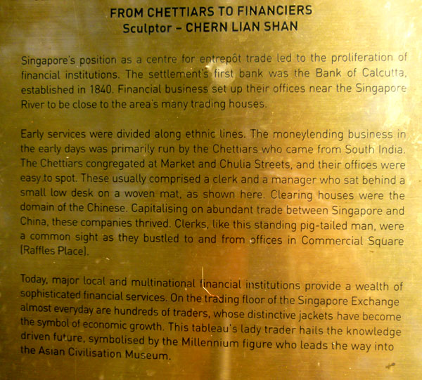
This sculpture is one of four pieces that are part of the People Of The River sculpture series depicting various historical scenes of people who lived and worked along the river. It commissioned in the early 2000s by the Singapore Tourism Board. The other three pieces - First Generation, From Chettiars to Financiers and A Great Emporium - are also located nearby.
|
 |
As we made our way from the Singapore River over to the Padang, we passed a number of other monuments and buildings of note. First of all, the Dalhousie Monument was between the Asian Museum and the Victoria Theatre and Concert Hall.
|
The building began as the Town Hall in 1862; the Victorian Revival structure originally housed a theatre, government offices and the Singapore Library. The entertainment use expanded, and by 1893 the offices and library had moved out of the building. In 1901-1905, a public hall was added, dedicated to Queen Victoria who died that year. Funds were sufficient to also renovate the original town hall structure to harmonize the facade of the whole structure.
The two buildings, the town hall and the Victoria Memorial Hall, were joined together by a clock tower built in 1906 to give the impression of a single building. The 160-foot-high tower connects the two buildings with a common corridor, and is topped by a timepiece donated by the Straits Trading Company. By 1909 the constructions and renovations were completed and the combined bbuilding reopened with a production of The Pirates of Penzance. The cultural use of the building was interrupted during World War II when the memorial hall was used as a hospital for victims of bombing raids by Japanese forces during the Battle of Singapore before their successful occupation of the colony. After the war, the Japanese war crimes trials were held here. Since then, the Hall has hosted mostly cultural events once again.
The Singapore Parliament buildings lie behind the Victoria Theatre, and so we don't have good photographs of the complex. But just east of the Parliament were two important structures- the National Gallery (fronting on the Padang) and the Supreme Court of Singapore to the north of it.
|
The present Supreme Court Building, which lies just north of the old building was constructed between 2002 and 2005. The 800,000 square foot building is clad in translucent sheets of Portuguese rosa aurora marble. The liberal use of glass in atria, skylights and lift shafts, and the open layout of the building, are said to signify the ideal of transparency in the law. Operations in the building started in June 2005, although the building was officially opened by the Singaporean President at the Opening of the Legal Year ceremony on 7 January 2006. There are 12 civil courts, eight criminal courts and three appellate courts. High Court hearings take place in courtrooms on the second through sixth storeys, while the Court of Appeal is on the ninth storey, the highest level, in a disc-shaped structure that is a modern interpretation of the Old Supreme Court Building's dome and is intended to represent the impartiality of justice. You can see that disc-shaped structure rising above the National Gallery.
From our viewpoint to the National Gallery, we walked northeast towards a monument we could see in the distance. This would also be our route home. The sidewalk we were on went alongside the Padang (where the bus had dropped us earlier). The Padang (Malay for 'field') is an open playing field which includes the Padang Cricket Ground. Due to its prime location and historical significance, it has been used as a venue for a variety of events, including the National Day Parades. It was Thomas Raffles, the founder of modern Singapore, who insisted on setting aside a large space along the Singapore River for public use in 1819. His public space is largely the same today, and here is a panoramic view taken from the walk:
|
As we walked along the side of the Padang, we were under a canopy of different trees, each with a small plaque attached to it; the plaque identified the tree- like this rain tree. As it turned out, these were Singapore's "Heritage Trees"- a collection of native trees that were found in the area as the Europeans arrived and spread. We could see, at the northern end of the Padang, the old Cricket Club (now the Singapore Recreation Club) and, in the distance, the convention center and Stamford Hotel- one of Singapore's iconic buildings.
|
|
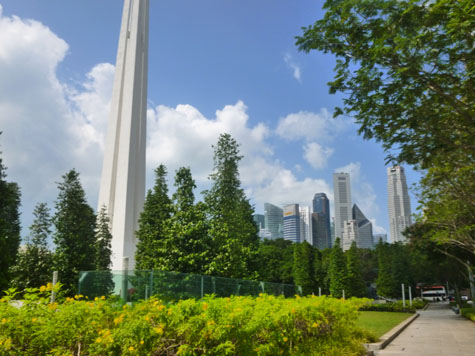
The Memorial to the Civilian Victims of the Japanese Occupation, usually called the Civilian War Memorial, was built in memory of the civilians killed during the Japanese occupation of Singapore during World War II. The Civilian War Memorial sits on serene parkland block in the midst of busy Singapore.
During the Japanese occupation of Singapore, somewhere between 25-50,000 Chinese were killed by the Japanese; in 1962, when remains were unearthed in several areas, the Singapore Chinese Chamber of Commerce undertook to gather the remains and create a memorial. In 1963, Prime Minister Lee Kuan Yew set aside the current plot of land, funds were raised (public and private), and creation of the monument began. A design competition resulted in a plan for four identical pillars, each 230 ft high, to represent the shared experiences and unity of the four major races of Singapore;– Chinese, Eurasian, Indian and Malay.
Construction began in 1966, and that same year 606 urns containing the remains of thousands of unknown civilians from the mass graves were interred on either side of the memorial podium, adding to the material significance of the structure whose history it represents. The memorial was completed the following year, and on February 15th, 1967, the Civilian War Memorial was officially unveiled by then Prime Minister Lee Kuan Yew, who laid a wreath at its base. Here are two more views of the memorial and its surroundings:
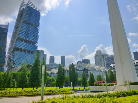 Looking North to South Beach Tower |
 Looking South to Downtown Core |
From here, we walked along the route the bus had taken earlier to get back to the Ibis Hotel, check out, and head to the ship.
Walking Back to the Ibis Hotel
Beginning at the War Memorial, our walk back to the Ibis was simple- requiring us only to walk four or five blocks up Bras Basah Road to Bencoolen, and then up that street six blocks to the Ibis. Along the way, we passed Greg's Hotel, street art, and some interesting architecture.
|
|
The development features two towers, 45 and 42 storeys tall, which house two luxury hotels, offices and apartments. The original conserved military buildings of the old Beach Road Camp were restored for retail and hotel-related uses such as function rooms. The builders promised to adopt an environmental design and green technology, and the British design firm delivered.
There is a large "environmental filter" canopy that covers the open spaces, linking conservation buildings with the two high-rise towers and providing shelter from the elements and drawing air currents to cool the area beneath it. The canopy rises at some areas and lowers at others, resembling huge waves. Some parts of the canopy hover around one conservation block, another covers it, while yet another part appears to go into a block. Other parts of the canopy also appear to rise skywards, covering part of the façades of the two new towers. Those towers have slanting façades to catch winds and direct air flow to the ground-level spaces. The building façades also incorporate photovoltaic cells and a catchment system that collects rainwater off the towers and the canopy to flow into a holding tank underground, instead of being wasted.
After reading about the development on the plaque at the corner, we wished that we had the time to go in and wander around to have a look at the architectural elements, but, sadly, there wasn't sufficient time. We continued up Bras Basah to go past the hotel that everyone else was staying in.
|
|
| "Specially commissioned by the Carlton, the sculpture celebrates the birth of a new chapter in the hotel's history. The Tree, home to the Birds, subtly signifies that the hotel is a home away from home, providing travellers a haven for rest and rejuvenation. The resting Birds exude a quiet aura of contentment and peace, thereby creating an interesting ambience of serene tranquility amidst the bustling Garden City of Singapore." |
We went inside to call Greg's room to see if he was there and to find out what time he would be leaving for the ship, but he and the other guys, as it turned out, were still at breakfast. We did stop to admire the Chiluly glass installation in the lobby.
Heading further up Bras Basah, we got a final view of Downtown Core as it would now be hidden behind other structures. On our way back, we passed at least three places that were advertising Singapore's signature libation which, if the ones I had on the airplane are any indication, tastes like sweetened fruit juice.
|
Gillie and Marc Schattner are a collaborative artist couple known for public sculptures. Their sculptures feature animals, and human-animal hybrids. The met in 1990 on a film shoot in Hong Kong, where Gillie (Catholic) was a model and Marc (Jewish) was the creative director. They married seven days after they met, in a Hindi ceremony, and lived in Singapore and New York before settling in Sydney in 2018.
Perhaps they left New York because of a controversy over one of their sculptures in Chinatown and the critical review of another, of the last three Northern White Rhinos in Astor Place. New York art critic Jerry Saltz called their work "a kitschy monstrosity," and said that it "proves my adage that 95 percent of all public sculpture is crap."
In 2013 Gillie and Marc created a series of sculptures depicting dogs holding cameras, which were exhibited in Melbourne, Sydney, Beijing, Shanghai, New York City, and this installation here in Singapore.
Next, we passed the Singapore Art Museum which was having an archaeological exhibit. That being one of Fred's interests, it would also have been nice to have the time to go in for a while, but we had to satisfy ourselves with just another picture- of the statue over the entrance. We also walked past the Singapore Management University, which had a sign by Bras Basah that made me think I was back in Dallas. At the corner of Bencoolen and Bras Basah we passed the National Museum of Singapore:
|
We turned at Bencoolen to head up the street to the Ibis. Along Bencoolen are two art and design universities, and so along the way we passed a number of examples of street art.
|
|
|
Also on Bencoolen we discovered that Singapore, like many other cities, including Dallas, has been invaded by bike sharing services. These have not been very successful in Dallas; indeed, I think that their business model doesn't take into account human nature and is doomed to fail, but that's just my opinion. We've tried the bikes, and while they work well enough, the logistics necessary to place them where and when they will be needed would seem to be too difficult to work out. While keying them to credit cards and smartphone apps gets you past the renting function, the return function is much less well-thought-out. In Dallas, the bikes may be left anywhere, and the result has been that they are left everywhere- certainly not necessarily where someone else would need to find them. Loss and/or damage are another issue; I have no idea how that issue can be solved.
At one-thirty we were across the street from the Ibis, our visit to Singapore having come to an end. Forty-five minutes later we were in a taxi on the way to the cruise ship port for the next portion of our round-the-world trip.
You can use the links below to continue to another photo album page.
 |
April 8, 2018: Marina Sands and The Gardens By the Bay |
 |
Return to the Index for Our Visit to Singapore |