|
August 4, 2024: Fred's 70th Birthday Party |
|
June 8 - July 2: A Trip to Fort Lauderdale |
|
Return to the Index for 2024 |
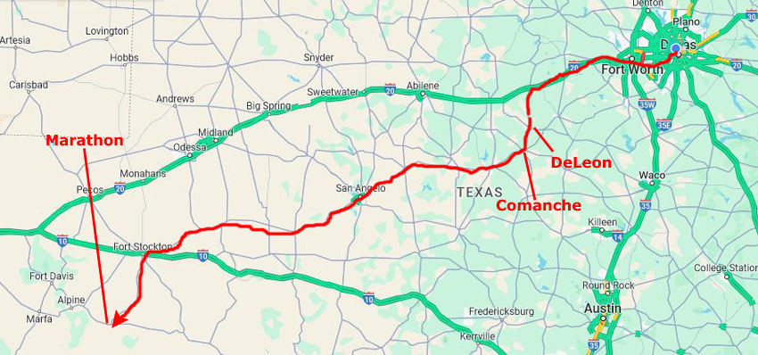
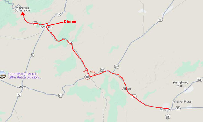
Prudence has asked Fred and I to join her and Ron, Nancy and Karl, and two of her artists for a trip to Marathon Texas and a stay at the Gage Hotel. We were happy to have the invitation, and of course looked forward to seeing our San Antonio family, and accepted with pleasure. We planned to meet at the hotel at 5PM on July 5th.
Getting to Marathon, TX
|
The reason our route was different this time was that on the way down to Marathon, Fred wanted to stop at his Aunt Charlotte's house just north of DeLeon, as she had said a while ago that there was something she wanted to duscuss with him in person. So we took this opportunity to do that.
We headed out west on I-20, turning off to the south to get to DeLeon. We stopped at Charlotte's and had a nice visit with her and her husband. They are both getting up in years, and Charlotte is recovering from a fall. But they were alert and in good spirits and Charlotte and Fred had their time to talk.
When we left Charlotte's house, we headed through DeLeon south to Comanche where we came to the intersection with US 67. Right on the corner, there is a buffalo and Indian statue that commemorates the founding of Comanche (hence the Indian). We then headed west on US 67. We basically followed that road through a number of small towns, and a couple of larger ones- like San Angelo. Continuing to angle southwest, we met up with I-10 and took that a short distance to Fort Stockton, where we again turned south for the last 75 miles to Marathon, arriving there about 4:30. Just ahead of the crew from San Antonio, as it turned out.
Marathon, Texas
|
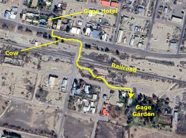
The Gage Hotel is on US Highway 90, and almost all of Marathon is on the north side of that road. One of the main east-west railway routes of the Southern Pacific Railroad is just south of the street, about two hundred feet from the hotel itself. On the other side of the tracks to the south were a couple of commercial buildings and a few private homes, as well as the Gage Gardens- a small arboretum-like garden tied in to the hotel itself.
North of the hotel are such private homes as there are in Marathon, which is not all that big. We did take a walk one morning with Jax up to Eve's Garden B&B, where I think Nancy said she'd stayed with Karl on one of their trips out west.
Marathon is the second-largest town in Brewster County, located twenty-six miles southeast of Alpine in the northern part of the county. The town was founded in 1882 when the Galveston, Harrisburg and San Antonio Railway built across what was then part of Presidio County- although there were already settlers in the area. Two brothers from San Antonio, Solomon and Mayer Halff, established their Circle Dot Ranch nearby, and in 1879 the federal government established Camp Peña Colorado there. Capt. Albion E. Shepard established the Iron Mountain Ranch in 1882. In his application for a post office, which was opened in 1883, Shepard named the site Marathon because its terrain reminded him of the plains of Marathon, Greece. At the time, there were about 125 residents in the area.
The railroad turned Marathon into a shipping and supply point for area ranchers and slowly more residents and businesses (and cattle and sheep) moved in. In 1897, Brewster county, Texas' largest, was established. In 1888 a one-room building was constructed to serve as a school, church, and community meeting hall. The population was 110 in 1896, and by 1909 Baptist, Catholic and Methodist churches had been established and a new three-room school built. There was a jail for a time, until it was moved to Alpine, and also a newspaper (which ended publication in 1919).
|
In 1914 the estimated population of Marathon had grown to 600. Among the businesses operating in the town were the Border Rubber Company, the Chambers Hotel, the Hustler newspaper, four cattle breeders, three general stores, a bank, a telephone company, and a pool hall.
During the 1920s Marathon was plagued by a series of fires of mysterious origin; arson was suspected, but no suspects were ever apprehended. In 1925 the estimated population had fallen to 218, but two years later had climbed to 1,000. In 1928 oil was again discovered; several test wells were drilled near Marathon, but the results were disappointing. Marathon was not destined to become an oil boomtown, and the estimated population varied from 750 to 1,000 for the next two decades.
The Gage Hotel
|
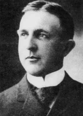
In those days, Marathon did not offer much in terms of lodging, so eventually Gage decided to build a hotel to use as a base to oversee his ranching operation. In 1926 he commissioned famed El Paso architect, Henry Trost, to design and build the property. An excellent example of Mission and Spanish-style design, the hotel officially opened for business in April of 1927. During that time period, Trost designed a number of other noteworthy hotels in the region, including the Paisano Hotel in Marfa, the Holland Hotel in Alpine and the El Capitan in Van Horn. Sadly, before being able to fully enjoy the newly completed hotel, Alfred Gage died just one year after it opened.
For several decades the hotel continued to serve those who ventured into the region, housing high-profile guests including Mount Rushmore sculptor, Gutzon Borglum and writer Zane Gray, who as legend has it, penned his most famous Wild West novel at the Gage. Marathon did not fare well, though. At one time in the late 1940s three wax factories were operating in Marathon, but all three were gone by 1954. Commercial beekeeping rose, peaked in the 1940s and then declined. A fertilizer company operated for fifteen years until it moved to Alpine. By the early 1970s, the population had fallen below 800. Because of the lack of commerce, the number of guests at The Gage dwindled. For many years, the hotel offered little more than haunted hallways until a fortuitous turn of events occurred when JP Bryan purchased the hotel in 1978.
A descendant of Stephen F. Austin, the founding “Father of Texas”, Bryan understood and appreciated the historic value of the hotel property, and, like Alfred Gage, had a vision for its future. JP’s passion for the Big Bend region, which in his words offers some of the most intriguing landscape in the entire West, and his love of the history of Texas, has led him through a 30-year restoration of the of the property and the town. The result of his work, which in ongoing, offers those who visit the region a truly authentic and unique place to enjoy the region and hopefully, share the vision and dreams of both Alfred Gage and JP Bryan.
|
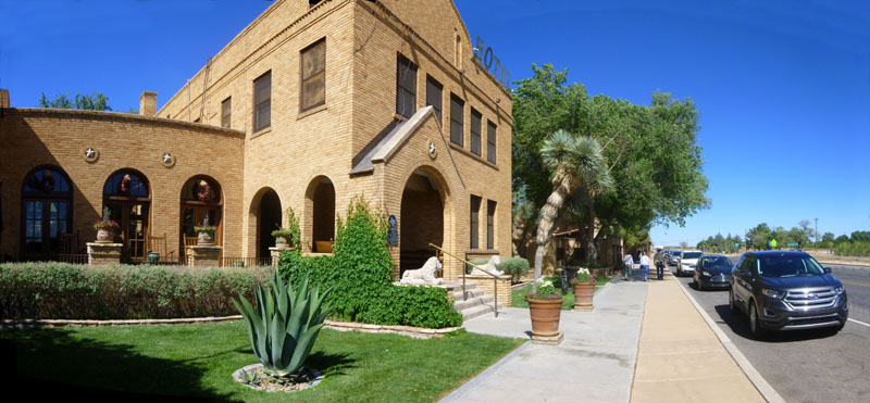
As you read above, the Gage is an historic hotel, dating from the 1920s. It is a Texas Historic Landmark and is on the United States Register of Historic Places.
The Gage has been restored a number of times since it was built, and the latest renovation has brought it well into the 21st century. One of the most interesting rooms is the main lobby. It wasn't very large, but it was very nicely appointed, with a definite "frontier" feel.
This is the third time we've been here to the Gage Hotel with Prudence, and on the other album pages for our trips here you can see numerous pictures we took at the hotel. This time, we took only a few pictures of the hotel itself during our three-night stay, and I am going to put them all here. For example, one evening when we had dinner in the White Buffalo Restaurant (the hotel's dining room), we were sitting in a small room that had a large painting on the wall over our table, and it was interesting enough to photograph:
 |
If you leave the rear door from the main lobby, and walk towards the casita rooms to the west, you will pass through another archway into an area that is where the hotel's pool is located. The pool is really nice, and although we didn't have an opportunity to get in it during our short stay here at the Gage Hotel, I did take a few pictures of it:
|
|
Lastly, on our last night here, I took this picture of Fred at the entrance two the hotel bar.
Prudence and Ron as well as Nancy and Karl and Susan Riley stayed out in the casitas. Nancy likes the rooms there, and it is only in the casitas that dogs are allowed. Prudence arranged for a really nice room in the main building for Fred and I (and we thank her very much for doing so). The room was at the front of the hotel overlooking the main street through Marathon and south towards Big Bend itself. There was a queen-size bed and beautiful antique furniture, along with a very nice bath. Our thanks again to Prudence for her generosity.
The Gage Gardens
|
In the aerial view at left, I've marked the hotel complex, and you can pick out the main building, the swimming pool, and the casitas at the west end of the property. I have also marked the railroad that parallels US 90 for quite a distance, beginning many miles east of Marathon and continuing almost all the way to Alpine, the next town to the west.
The main reason for the aerial view, though, is to show you where the Gage Garden is relative to the hotel. To get to it, which we did each day to give Jax some exercise, one crosses US 90, then follows Avenue D across the railroad tracks. Right near Avenue D, and just across from the hotel's restaurant, there is an interesting sculpture, which is presumably a longhorn.
I always find the railroad tracks interesting, and not just because trains come through a few times a day and are interesting to watch. No, the tracks are more interesting and evocative of how isolated Marathon is when you stand on them and look either east or west towards the Davis Mountains. To me, both these pictures evoke the breadth of this West Texas area- and how empty is it outside of the few small towns like Marathon, Alpine, and Marfa, that dot it.
Once you cross the railroad tracks, you can angle a bit southeast along a gravel path through some native plantings to come out across from the the entrance to Gage Gardens.
|
To make the pictures we took on our various visits to the garden, I think an aerial view is helpful, and I have included one at left. On this aerial view, I have marked some of the major features that we encountered in our walk through the gardens on the four or five trips we made over here during our stay.
Sprawling across 27-acres of lush greens, the Gage Gardens encompasses a native landscaped garden park with lovely ponds, beautiful fountains, a putting green, rose garden, vineyard, fruit orchard and a large fire pit with banquette seating.
Blooming with colorful indigenous plants that flourish year round, the garden is a welcome home for migrating birds and butterflies, and provides the ideal spot for a relaxing walk a partner or pet, an afternoon picnic, a wedding or a private party. Conceived by the hotel's owners in the early 1980s, by 1990 the gardens were pretty much in their current form, although occasional improvements or additions have been made by the owners, who consider the gardens to be their main hobby.
It was an interesting place to walk through and a great spot to relax, and I of course want to show you some of the pictures and movies that we took on our trips here. For example, as soon as you pass through the gates, you are on a wide walkway leading to a fountain. I have always enjoyed this fountain, and this time I made a movie so you can enjoy it, too.
|
|
The fountain and pool seemed incongrous out here in the middle of the high desert. I thought that the fountain right at the entrance was really pleasant and I would have been happy to just sit and listen to it, but we'd come to see the gardens and after we took a couple more pictures of the fountain we moved on:
|
|
Just past the fountain there is a small building with some facilities, and adjacent to that is a firepit with some stone seating around it. We never saw anyone using the firepit, but perhaps at night some hotel guests will use it. Anyway, it is a nice place to sit in the shade.
|
|
|
 |
As you walk along the path, you pass the putting green on the left. In a little shelter nearby there is usually a supply of putters and some golf balls for kids (and adults) to use to practice their golf skills.
|
|
The path leads to the far end of the gardens where you can find a formal rose garden. This was midsummer, so there was a paucity of lush blooms, but still there were enough to make a visit interesting:
 |
|
|
|
|
Actually, to the south of the garden area there is an additional six or eight acres that are not cultivated but left to native plants and a small pond. This is an area where dogs can run wild, and there is a mile-or-so-long path that encircles this area. On the way back to the entrance, there is another small artificial pond near the putting green, and it has its own fountain.
|
The Second Fountain in the Gage Gardens |
|
|
A Day in Big Bend National Park
|
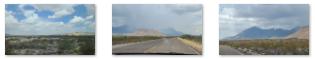
While we have driven over to Terlingua before, I don't recall ever going up that highway to Alpine. In any event, the scenery between Marathon and the Park Entry Station (about 20 miles north of Panther Junction) is beautiful in its own way. I was driving, so it fell to Fred to take a few pictures of the landscape we passed.
|
At Panther Junction
|
Here are some of the pictures we took when we stopped at Panther Junction to plan our day in the park:
|
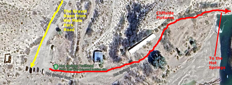
Rio Grande Hot Springs
|
There is a section where the road hugs a ravine wall, and this section is so narrow that the road becomes one-way on each side of the ravine. It was a little nerve-wracking for me but I can only imagine that the folks riding with Ron, whose truck is a good deal wider than my car, might have been a little nervous as well.
But after the one-way section ended, we arrived in the parking area, found a spot, and headed off to the trailhead for the path to the hot springs. Right by the trailhead there were some interesting signs explaining the old structures in the area, and I thought you might want to read them:
 |
 |
Most of this signage was right at the trailhead, and here you can see us reading about the trail and area.
|
|
Sadly, as you will learn shortly, we didn't make it to the actual hot springs right by the Rio Grande. But we did get a chance to visit most of the sites that were described on the largest of the signs at the trailhead.
|
While young folks wouldn't have much problem walking the twenty feet on this wall to bypass the area of the trail that was flooded, we seniors could well have a problem- either losing our balance and stepping into inches of water and mud or, worse, losing our balance in the other direction and falling into the (shallow) river.
Neither option seemed appetizing, and while Fred and I might well have balanced on the brick-wide wall to bypass the blockage if we had been here on our own, expecting everyone else to do so was completely unrealistic. So that's why we never got to the actual hot spring at the river's edge. But we'll talk about it anyway, so that if you decide to visit here, you'll know what to expect.
The first point of interest was actually on top of a hill on the other side of the parking area from the trailhead.
|
 |
The next stop, only a hundred feet down the trail, was the Post Office and General Store.
|
|
We took a few photos here:
|
|
Passing this first stop, we continued along the trail, arriving at the third marked stop- the Motor Court.
|
|
I know that it is impossible to read, so if you will click on the text at lower left, or the two pictures and text at the lower right, or the inset picture in the upper right, I will enlarge that section so you can actually read it.
Before we headed on down the trail, I stepped back to take in the entire Motor Court:
 |
The next point of interest on the trail was an opportunity to see some petroglyphs and pictographs. The best viewing for these was on a short side trail to our left that led up ten or twenty feet to a trail along the cliffside.
|
|
I've put a picture of the sign at left. In the picture, you can click on the section of text at the left, the banner of text at the bottom, and each of the picture/caption units in the upper right and I will open that part of the sign in a new window, at a size that should be easily readable. Just close each window when you are done with it.
It wasn't really necessary to go up to the trail along the cliff, to see the rock art, but there were better views up there and so Fred and I scrambled up to get a look. First are some views looking along and out from the cliff trail. First is this panoramic view of the Rio Grande flowing past:
 |
And now some views looking along the cliffside:
|
|
|
From up on the cliff trail, we (actually Fred) got some pictures of the rock art:
|
|
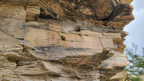 |
Fred and I came back down to the main trail and walked a bit further with Prudence and Nancy until we found our way blocked.
|
|
So, with discretion being the better part of valor, we decided to end our walk here and head on back to rejoin Ron and Karl. Before we did so, Fred took the picture at right.
|
As we were heading back, Fred and I each took some additional pictures looking out at the scenery here by the Rio Grande River:
 |
 |
 |
 |
We made our way back to the parking area and headed off back towards Panther Junction and to the turnoff for the road up into the Chisos Basin.
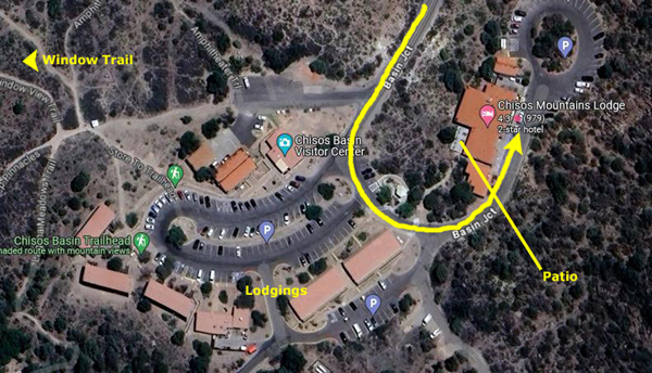
In the Chisos Basin
|
To view the slideshow, just click on the image at left and I will open the slideshow in a new window. In the slideshow, you can use the little arrows in the lower corners of each image to move from one to the next, and the index numbers in the upper left of each image will tell you where you are in the series. When you are finished looking at the pictures, just close the popup window.
The drive from the hot springs to the Basin took about an hour, and at the Basin we met up again with Ron, Prudence, and Karl.
|
 |
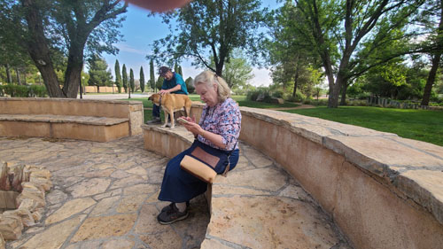
The restaurant was closed, so we had to content ourselves with some drinks out on the patio:
 |
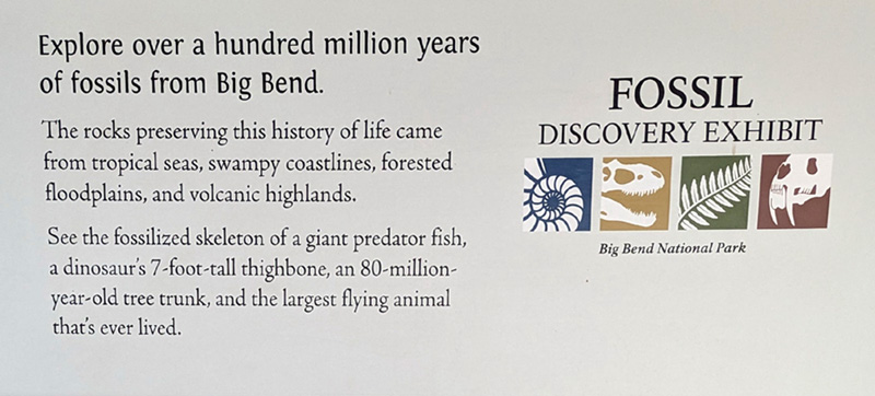
As we were sitting there, enjoying the cool air, it got even cooler and then windier as some rainshowers began to move into the valley. We had to get back to Marathon, so we headed off in our two cars to get back to the Gage Hotel. Fred and I wanted to make a stop on the way back at the new Fossil Discovery Exhibit which is just off the park road on the way back to Marathon.
At the Fossil Discovery Exhibit
|
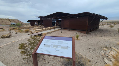
The Fossil Discovery Exhibit is the most significant addition to Big Bend National Park’s visitor services system in the past 50 years. Thanks to the generosity of individuals, corporations, and foundations across the state, this $1.4 million exhibit gives park visitors the opportunity to meet the past right where actual fossils were found.
The site of the Fossil Discovery Exhibit in Big Bend National Park has a long-standing history of providing paleontological information to curious park visitors. John Wilson, the founder and first Director of the Vertebrate Paleontology Laboratory at the University of Texas at Austin, oversaw the establishment of the first paleontology exhibit in Big Bend National Park in 1957. This exhibit, then called the Fossil Bone Exhibit, was one of the first of its kind within the NPS, displaying actual mammal fossils as they had been discovered. The fossils remained in the rock where they were uncovered, but a building was constructed around the rocks to allow visitors the opportunity to see a naturally occurring fossil. The fossil mammals were from the Hannold Hill Formation (55 million years ago) and included early mammals like the primitive horse-like Hyracotherium and the hippo-like Coryphodon. The site remained a popular roadside stop for visitors until the 1990s.
When we pulled into the parking area, we could see the new Fossil Discovery Exhibit as well as the walkway that led up to the top of a natural hill from which you could see the area of the park where these fossils were found.
|
Big Bend National Park geologist Don Corrick had worked at the park for over twenty years. He had dreamed of replacing the outdated display of casts with an exhibit that did a better job celebrating the diversity and abundance of fossils found in the park. After years of advocating for a new exhibit, and with help from the Big Bend Conservancy and the National Park Foundation, Corrick’s vision has finally come to life with the opening of the Fossil Discovery Exhibit.
Before we went inside the new building to see the actual exhibits, Fred and I took some outside pictures that will be of interest.
|
|
Here is the sign that you saw in the picture, above left. It is entitled "Sustainable Design":
 |
Here are some additional scenes just outside the new exhibit building:
|
|
 |
There was some additional signage out front that I photographed so you could read it (and I could eventually read it again):
 |
 |
 |
 |
Next, we headed inside the exhibit building. The exhibits were basically in chronological order and were organized into three major sections- the Marine environment when this area was at the bottom of a shallow sea; the period of the dinosaurs, during the time when the Big Bend area was either a coastal floodplain or an inland floodplain environment; and the period after the extinction of the dinosaurs when the area was a volcanic upland and mammals of all kinds made their appearance and evolved.
I tried to photograph as much as I could inside the building, as there was much more than I could stop and read in the short time we had here. I intended, as I have done in museums, to photograph everything so I could read it at leisure later. While photographing artworks and their explanatory placards on museum walls is straightforward, trying to photograph items and their descriptions when they are in glass cases is much more difficult, and many of the photos I took didn't turn out as well as I had hoped.
So, since not all my pictures turned out well, I want to supplement them with information that you can read for yourself on the actual website for the Big Bend National Park Fossil Discovery exhibit. There were five general groupings of exhibits that roughly corresponded to the five "environments" on the actual website, and this give me a reasonable way to organize the pictures that I took that actually turned out decently.
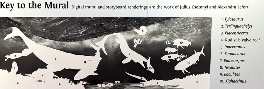
Below, you will find a heading for each environment and the mural for it that was wall-mounted in the exhibit hall. I found that for most of the murals, there was also a kind of "key" somewhere in the exhibit- usually right near the mural itself. This key was essentially a copy of the mural with the creatures changed to white outlines and numbered, with those numbers listed at the side with the names of the creatures. I photographed these "key" murals and the name lists and put them next (sometimes transcribing the lists when my photo wasn't really clear). (Sometimes, I found, the "key" image was wider than the mural, and consequently creatures appeared in the key that were cut from the mural- why, I don't know.)
Below the mural (and its key, if any) I've put the general description of the "environment" taken from either the placard mounted beside the mural in the exhibit hall or, where my photo wasn't clear enough, the description taken from the Fossil Discovery Exhibit's website.
Then I included the photographs we took in the exhibit building. We didn't photograph everything (although I, for one, tried). Mostly there wasn't enough time, as we had to be back in Marathon in time to head off to the Star Party at the McDonald Observatory. It was also tough to try to photograph things "in order", as there really wasn't a specific order- just general groupings of exhibits for the five "environments", and I missed some sections. Besides that, the buildings were open-air and there was lots of glass, and so many of my pictures didn't turn out well because of glare, reflections, or both. But I've taken the photographs that did turn out decently and put them in slide shows (or in one environment where only a few pictures were taken, I just put them right on the page).
Finally, there was lots of additional information on the fossil exhibit's website, so at the end of each section I put a link to the corresponding section for each environment on that website. If you choose to follow the link, it will open in a new tab, preserving your place in my online photo album, to which you can return at any time. In that new tab you can, of course, wander off on your own through the entire Big Bend Fossil Discovery Exhibit website, but be sure not to get totally lost; you'll want to return here so as not to miss the McDonald Observatory Star Party, our tour around Marfa, and the other things we did on this trip to West Texas.
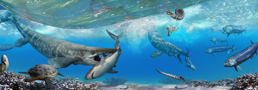
The Marine Environment
|
Alongside these “monsters of the sea” lived ammonites, turtles, sharks, sea urchins, oysters, and snails. The rocks from this time period yield many scientific treasures. For example, the oldest North American mosasaur was discovered in the limestones at Big Bend National Park.
|
To view the slideshow, just click on the image at left and I will open the slideshow in a new window. In the slideshow, you can use the little arrows in the lower corners of each image to move from one to the next, and the index numbers in the upper left of each image will tell you where you are in the series. When you are finished looking at the pictures, just close the popup window.
Coastal Floodplain
|
The mural available for the Coastal Floodplain Environment seemed not to be complete, as the key for the mural in the actual exhibit was considerably wider. So my picture of the key below shows the outlines of creatures that don't appear in the mural above.
|
|
To view the slideshow, just click on the image at left and I will open the slideshow in a new window. In the slideshow, you can use the little arrows in the lower corners of each image to move from one to the next, and the index numbers in the upper left of each image will tell you where you are in the series. When you are finished looking at the pictures, just close the popup window.
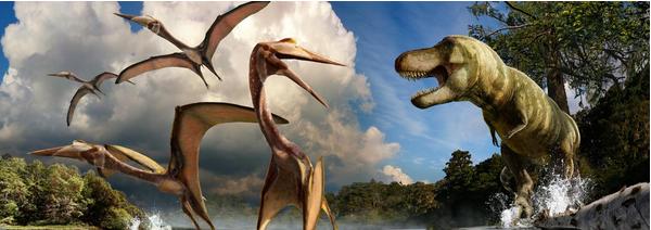
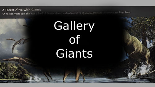
Gallery of Giants
|
|
To view the slideshow, just click on the image at left and I will open the slideshow in a new window. In the slideshow, you can use the little arrows in the lower corners of each image to move from one to the next, and the index numbers in the upper left of each image will tell you where you are in the series. When you are finished looking at the pictures, just close the popup window.
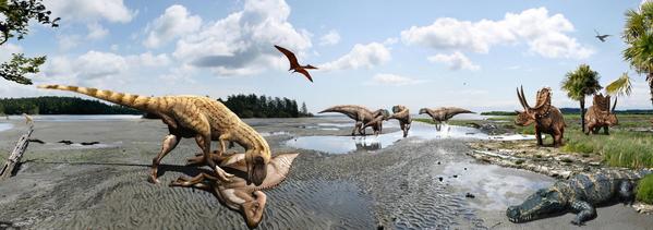
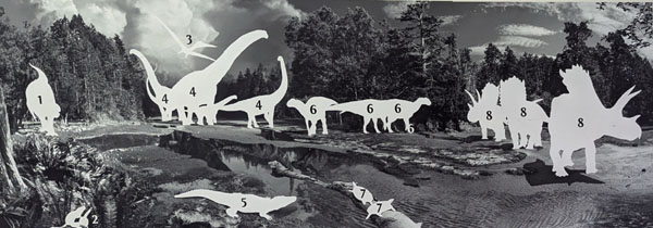
Inland Floodplain
|
As the Rocky Mountains rose higher and higher to the west, the compression of North America caused the land here in Big Bend to be warped downward, creating a broad, river-filled basin. This forested floodplain supplied many slow-moving meandering rivers that carried lots of mud, sand and silt. The landscape resembled today’s Brazos River valley in southeast Texas.
|
1. Tyrannosaurus 2. Meniscoessus 3. Quetzalcoatlus 4. Alamosaurus 5. Brachychampsa 6. Gryposaurus 7. Baena 8. Bravoceratops |
We didn't take a great many pictures in this section of the exhibit, and so, rather than a slideshow, here is the information from the exhibits that we did photograph:
 |
 The section at left is small, so it is enlarged below: The section at left is small, so it is enlarged below: |
 |
 |
 |
 |
 |
 |
 |
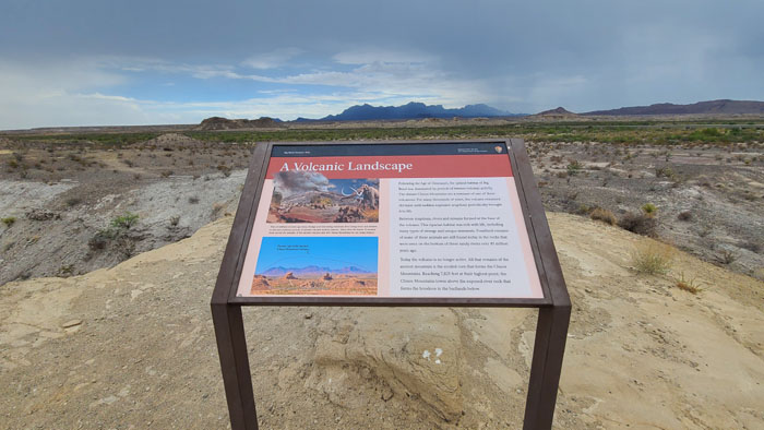
Volcanic Highlands
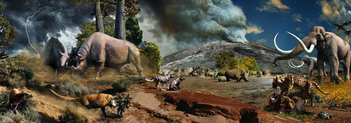 |
Here is a key to the Volcanic Highlands mural above:
|
The dinosaurs went extinct 65 million years ago. This mass extinction made way for a grand diversification of mammals. The Rocky Mountains continued their uplift to the west and sea level dropped even further as the continent rose. The ancient seaway that had previously divided North America during the time of the dinosaurs disappeared completely. The Big Bend region remained a large basin or “sunken block” that was filled with new silt, sand, and clay, preserving the bones of ancient mammals. From around 45 to 30 million years ago, Big Bend experienced many volcanic eruptions that laid down ash and lava. Mammals that thrived in Big Bend from 55 million to 10,000 years ago include a wide variety such as saber-toothed cats, primitive dogs, early lemur-like primates, huge rhino relatives, and even mammoths.
|
To view the slideshow, just click on the image at left and I will open the slideshow in a new window. In the slideshow, you can use the little arrows in the lower corners of each image to move from one to the next, and the index numbers in the upper left of each image will tell you where you are in the series. When you are finished looking at the pictures, just close the popup window.
If you would like to learn more about the Volcanic Highlands "environment" section of the Fossil Discovery Exhibit, please click HERE.
When we were done inside the exhibit (and if we'd had more time, it would have been nice to spend it taking a more in-depth look at the exhibits, which were extremely well done), we headed outside. While Nancy waited near the car, we headed up the walkway to the "Valley Overlook" to see what the views were like from there.
On the way, both Fred and I got interesting views looking back at the exhibit building and the parking area:
|
|
There were indeed some neat views from the top of this low hill, and there were also some interesting signs all around that you might want to read. First the views:
 |
|
|
And now for the signage:
 |
 |
 |
And finally, a panoramic view that I took from the top of the hill (note the exhibit building at the right):
 |
Coming down from the hill, we returned to the car and the three of us headed back towards Marathon and the Gage Hotel, ready to head off to dinner in Alpine and the Star Party at McDonald Observatory.
The "Star Party" at McDonald Observatory
|
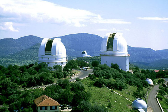
McDonald Observatory is located on Mount Locke in the Davis Mountains of West Texas, with additional facilities on Mount Fowlkes, approximately a mile to the northeast. The observatory is part of The University of Texas at Austin and is an organized research unit of the College of Natural Sciences. The observatory produces StarDate, a daily syndicated radio program consisting of short segments related to astronomy that airs on both National Public Radio and commercial radio stations.
McDonald Observatory was originally endowed by the Texas banker William Johnson McDonald (1844–1926), who left about $1 million — the bulk of his fortune — to The University of Texas at Austin to endow an astronomical observatory. Edwin Hockaday Fowlkes, step-son of the land's original owner, donated the land to the University of Texas to build the observatory. The provision of the will was challenged by McDonald's relatives, but after a long legal fight, the university received about $800,000 from the estate and construction began at Mt. Locke. The then-unnamed Otto Struve Telescope was dedicated on May 5, 1939, and at that time was the second largest telescope in the world. McDonald Observatory was operated under contract by The University of Chicago until the 1960s, when control was transferred to The University of Texas at Austin.
|
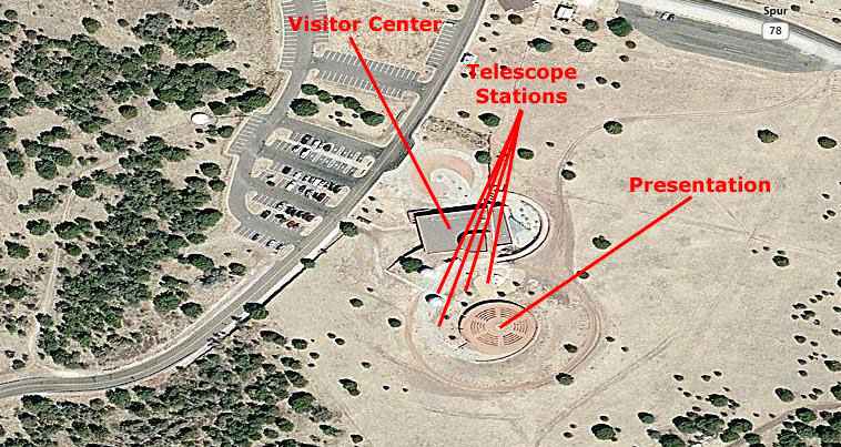
At right you can see an aerial view of the part of the McDonald Observatory complex where the "Star Party" event is held. You can, of course, see the parking area, but also the Bash Visitor Center and the curved walkway up from it to the amphitheatre where the actual presentation is held and along which there are telescopes set up for visitors to view various celestial objects.
Having been here before, we knew that the only opportunities we would have for picture-taking would be before the presentation began, so after we arrived and before the presentation began, Fred and I too some candid shots around the area. The best of these are below:
|
|
|
|
|
|
The 2-hour Star Party program is very much a family affair, and offers visitors an educational opportunity. The parties have become so popular that what used to be an open-ended affair in terms of attendance has now become a reservation only event. There are only a limited number of spaces available each evening, and reservations must often be made weeks in advance.
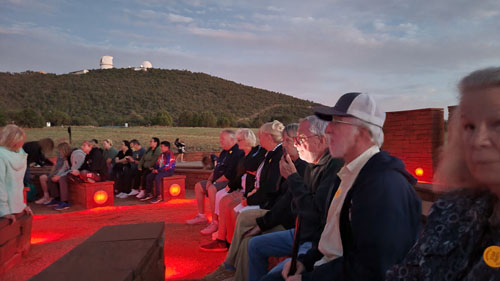
The Observatory's climate offers a high percentage of clear nights so, in general, most of the Star Parties occur on a clear evening, and ours was no exception. Our program began in the outdoor Amphitheater at the Visitors Center where we got a short introduction to the program; one of the admonitions was the restriction on the use of various light sources such as camera screens and camera flash, as these affect the dark adaptation process of the human eye and thus the enjoyment of views of the night sky. This, in effect, meant no photography, but that didn't matter much, as nighttime sky photography can't be done with handheld devices anyway.
|
In the picture, you can't quite make out all the people sitting in the pie-shaped seating sections, nor can you see the astronomer who was conducting the session. You can, however, see the powerful laser light that he was using to point out various stars and constellations. Using the pointer was very effective; one could always follow the beam of light to see the sky feature that he was talking about. This was particularly effective as he traced many of the familiar constellations (and some that were quite unfamiliar to most of us).
The Milky Way was only fairly distinct this evening, not quite so visible as in the stock shot. It looked more like a band of light clouds stretching across the sky. Even so, it was far more visible than it ever is in the urban areas with their huge amounts of "light pollution."
Seated in the amphitheatre, then, we were led by the astronomer through a constellation tour in which he pointed out the brighter stars and many of the constellations, related some of the practical uses of the stars, talked about the mythology of some constellations, and told us about the scientific understanding of various patterns and objects in the night sky.
As the night sky slowly changes from week to week, month to month, season to season, so too do the constellation tours as some constellations fade from view and others become visible at the time of the show. These constellation tours serve as an orientation to the night sky and can help make the telescope viewing to follow more meaningful. However, guests are always welcome to skip the constellation tour if they prefer to move directly to telescope viewing following the introduction.
|
We could move from telescope to telescope where different objects will be viewed in each telescope. Each station had a couple of observatory people manning the scope and talking with the people in line about what they would be seeing. We got the chance to actually view the celestial objects directly through these various telescopes with our eyes at the eyepiece- not on a screen (which is why issues regarding night-adaptation are so important).
The person manning the scope helped people in the viewing process and also made sure that the telescope stayed on target. After all, the earth is constantly in motion which means that objects would eventually move out of the telescope's field of view unless its position was constantly adjusted. At one station, we were among the last people to view one particular object before it moved too low in the sky for the telescope to be trained on it.
Waiting in line for the telescopes was made interesting in itself with the presence of someone to whom we could direct questions- and everybody always had some interesting ones to ask. I recall that I learned a lot I didn't know (which isn't all that unusual), and the questions and answers made it seem as if every line moved quickly.
This was a great evening for viewing, but then that's why the observatory was built here and not somewhere else. We went to every telescope, and saw all we could. We enjoyed the Star Party immensely, and want to thank Prudence for treating us to it and Karl for arranging it.
Marathon's Independence Day Parade
|
|
We went to a local cafe near the hotel for some breakfast, and then joined the couple dozen people who lined the street to watch the very-much-adhoc parade (which, apparently, anyone could join).
|
To view the slideshow, just click on the image at left and I will open the slideshow in a new window. In the slideshow, you can use the little arrows in the lower corners of each image to move from one to the next, and the index numbers in the upper left of each image will tell you where you are in the series. When you are finished looking at the pictures, just close the popup window.
A Day in Marfa, Texas
|
Marfa is a city in the high desert of the Trans-Pecos in far West Texas, between the Davis Mountains and Big Bend National Park, at an elevation of 4685 feet. It's the county seat of Presidio County. It's population peaked and now stands at about 1800. Today, Marfa is a tourist destination and a major center for minimalist art. Attractions include Building 98/Fort Davis, the Chinati Foundation, and the Marfa lights.
Marfa was founded in the early 1880s as a railroad water stop. The town was named "Marfa" (Russian for "Martha") after a character in a Jules Verne novel. There was some controversy about the naming, many saying that it came from a character in Fyodor Dostoevsky's novel The Brothers Karamazov. When an article about the controversy was published in the Texas Monthly received no comments or letters, the conclusion was that no one particularly cared.
|
Marfa experienced economic issues after the war ended and after a drought impaired agricultural output. Artist Donald Judd arrived in 1973 and began buying properties to renovate, which resulted in bohemian interest in the community. In 2012 Vanity Fair described it as a "playground" for "art-world pioneers and pilgrims".
When we arrived, we parked on the street near the Paisano Hotel, which is in a block that borders the town square (where the courthouse is located). I have put an aerial view of the downtown area (where we spent most of our time) at right. For space reasons, I have rotated the view so that north is at the left. I've marked on the view the places where Fred and I took pictures. In fact, the only place we even went that was outside this view was the Chinati Foundation, but more about that in a while.
So as we take a look at the pictures from Marfa, refer back to this aerial view as you wish.
At the Paisano Hotel
 |
Actually, you might compare the view above with another view we found hanging in the Paisano Hotel which shows Marfa from essentially the same angle- but in 1949:
 |
The Hotel Paisano has a long, storied, and sometimes troubled history in Marfa, having seen good times and bad times. It has been, and is now, an iconic location in Marfa and in West Texas.
|
With an army of workers, the Hotel Paisano was constructed and opened eight months later in June, 1930. At the time, it comprised 35,000 sq ft in two and a half stories, 65 rooms, each with a private bath, over 12,000 sq ft of retail, restaurant and office space and a roof-top neon sign that could be seen from miles away on Hwy 90. It would become known as “the most elegant hotel between El Paso and San Antonio.”
The main customers of the Hotel Paisano during the 1930s and 1940s were area cattle ranchers who came to Marfa to buy and sell their herds, and tourists who came to West Texas for the benefits of the dry desert air. The Hotel Paisano would continue to be the social hub for the area through the 1960s and became known as a meeting place and oasis to travelers on the busy railroad circuit.
In January 1947, Em Mallan purchased the hotel from the Bassett family, operated it very successfully, and lived in the hotel for the next 20 years. But it was in 1955 that the most significant event in the hotel's history occurred.
|
After the first two weeks of their visit, the three main stars moved to private residences in Marfa, but they all continued to dine at the hotel, socialize in the lobby and lounge areas, and meet to watch dailies from a projector that director George Stevens sets up in the ballroom.
A great many visitors were attracted to Marfa during the filming, all of them hoping to catch sight of their favorite iconic film star, and to large extent they came away satisfied, and the movie filming was the biggest thing to hit Marfa pretty much in its history. Actually, it was a tough act for the aliens to follow many years later.
There is a marker in the hotel lobby, placed by the Texas Historical Commission, and it reads: "The Paisano Hotel. Named for the nearby Paisano Mountain Pass, this structure was completed in 1930. Gateway Hotel Company, owners of several area hotels, built it in anticipation of a local oil boom that never materialized. The architectural firm Trost and Trost of El Paso designed the building. Constructed around a central courtyard area, the structure reflects Spanish Baroque styling. It was considered to be the finest hotel between El Paso and San Antonio."
Here are some of the views of the inside of the hotel and its courtyard:
|
|
|
|
|
|
One of the reasons we'd made the trip over here to Marfa was so that Prudence could see the exhibit of one of her artist's work that was currently on display here in the hotel. Anna Lisa Leal was shortly to have her own show at Prudence's gallery, and Prudence wanted to see what paintings the hotel was using here. I took a couple of photos in the room that the hotel had allocated for the exhibit:
|
|
Around the Marfa Town Square
|
San Antonio architect Alfred Giles beat out eighteen other competitors to submit the winning bid on designing the 1886 courthouse at a cost of $60,000. Giles modeled the Second Empire style building after the El Paso courthouse he also designed in 1886. When the structure was completed, the county held a celebratory grand ball on January 1, 1887.
The courthouse can be seen from almost any location in Marfa. Designed of brick and stone quarried in Marfa, the exterior is of pink stucco with Lady Justice sitting atop the central dome. The tower is spanned by Roman arches. Interiors are designed of pecan wood. Dormers extend over the roof, with triangular pediments and iron cresting. The building has entrances on all sides, meeting in a central rotunda. When designed, the district courtroom took up the entire east side of the second floor. The grand jury room was on the third floor. A remodeling took place in 2001.
The original Presidio County Courthouse was a plain facility, no longer extant, in Fort Davis. That building was in use from 1880 to 1885 when the county seat was relocated from Fort Davis to Marfa.
Surrounding the courthouse square on all sides are commercial structures, as is common in most Texas rural county seats. There are common layouts for the streets surrounding the square. One is like a checkerboard with the courthouse simply occupying one of the board's squares, and the square boundaries being streets. Sometimes, as in Marfa, the courthouse square is shifted east-west or north-south so that one street will be interrupted by the square. Here, when you drive north on Texas 17 past the Paisano, you have to turn right and go around the square to continue north on the same route on the other side of the square. Finally, there are some layouts where two streets are interrupted by the square (as if the square was placed squarely atop the intersection of four checkerboard squares).
We didn't walk to the far side of courthouse square from the Paisano, but across the street from the Paisano here on the south side of the square were a theatre and a kind of Marfa monument:
|
|
It is a testament to how small Marfa is (and perhaps how little visited it is) that there is nothing but a small fountain through the Marfa Doorway, and the Palace Theatre isn't a theatre at all. Well, it used to be, but it closed in 1970. It is now, believe it or not, a private residence. Whoever lives there must have one hell of a media room!
|
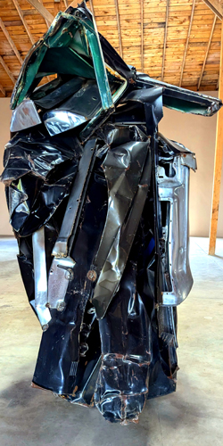
Chamberlain is best known for creating sculptures from old automobiles (or parts of) that bring the Abstract Expressionist style of painting into three dimensions. He began by carving and modelling, but turned to working in metal in 1952 and welding 1953. By 1957, while staying with the painter Larry Rivers in Southampton, New York, he began to include scrap metal from cars with his sculpture Shortstop, and from 1959 onward he concentrated on sculpture built entirely of crushed automobile parts welded together. Far more than just another wrinkle on assemblage Shortstop and subsequent works completely reinvented modeling, casting, and volume, altering Marcel Duchamp's notion of the readymade and using the car as both medium and tool. In 1962 Donald Judd wrote, "The only reason Chamberlain is not the best American sculptor under forty is the incommensurability of 'the best' which makes it arbitrary to say so."
By the end of the 1960s, Chamberlain had replaced his signature materials initially with galvanized steel, then with mineral-coated Plexiglas, and finally with aluminum foil. In 1966, he began a series of sculptures made of rolled, folded, and tied urethane foam including sofas. After returning in the mid-1970s to metal as his primary material, Chamberlain limited himself to specific parts of the automobile (fenders, bumpers, or the chassis, for example). In 1973, two 300-pound metal pieces by Chamberlain were mistaken for junk and carted away as they sat outside a gallery warehouse in Chicago.
In the early 1980s, Chamberlain moved to Sarasota, Florida, where an 18,000-square-foot warehouse studio on Cocoanut Avenue enabled him to work on a much grander scale than he previously had. Many of the subsequent works Chamberlain made in Florida revert to more volumetric, compact configurations, often aligned on a vertical axis. As seen in the so-called Giraffe series (circa 1982–83), for example, linear patterns cavort over multicolored surfaces—the results of sandblasting the metal, removing the paint, and exposing the raw surface beneath. In 1984, Chamberlain created the monumental American Tableau created for display on the Seagram Building's plaza.
An installation of 25 works by John Chamberlain is located in the former Marfa Wool and Mohair Building in the center of Marfa. The building was architecturally adapted by Donald Judd and installed by Chamberlain and Judd. Some of the exhibited works are from a group of ten sculptures constructed on a ranch near Amarillo, Texas, between 1972 and 1975 and are loosely named after towns and counties throughout the state. The works were purchased by the Dia Art Foundation and given to the Chinati Foundation in 1986.
|
To view the slideshow, just click on the image at left and I will open the slideshow in a new window. In the slideshow, you can use the little arrows in the lower corners of each image to move from one to the next, and the index numbers in the upper left of each image will tell you where you are in the series. When you are finished looking at the pictures, just close the popup window.
The Wrong Gallery
|
From their website, I learned that Wrong has been a gallery and store in Marfa, Texas since 2010. They moved uptown to their current location at 110 N. Highland in October 2019. The store is artist-driven and curated by Buck Johnston and Camp Bosworth. "We carry items by artist friends we know and love." All wood items are handmade by Camp Bosworth.
Their exhibition space features 7-9 artists a year. "If you have a unique product, not found anywhere else, you are welcome to email us at gonewrong@wrongmarfa.com. We do not welcome in-store inquiries."
Even the directions and hours had a quirky aspect to them: "Wrong is located at 110 N. Highland Ave. We are every day unless we're not. Come by and see us! We try to be open daily 12 to 5/6/7."
Here are a few of the pictures we took inside (and outside) the Wrong Store and Gallery:
|
 |
 |
A Couple of Final Pictures From Marfa
|
|
We returned to Marathon in the late afternoon, and had a very nice supper with the San Antonio crowd at the Gage hotel before heading back to Dallas the next morning. Yet again, we thank Prudence very, very much for her generosity in providing us with our lodgings at the Gage Hotel, and both her and Nancy for the wonderful meals in Marathon and Alpine, and Nancy and Karl for the Star Party at the Observatory.
You can use the links below to continue to another photo album page.
|
August 4, 2024: Fred's 70th Birthday Party |
|
June 8 - July 2: A Trip to Fort Lauderdale |
|
Return to the Index for 2024 |