

 |
October 6, 2009: Our Drive from Green Bay to Southern Illinois |
 |
Return to the Index for Our Midwest Trip |
Hiking in Matthiessen State Park
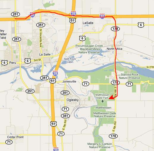
|
Matthiessen State Park was named for Frederick William Matthiessen, a prominent industrialist and philanthropist from LaSalle. He originally purchased the land near the end of the 19th Century and developed it as a privately owned park for many years. Mr. Matthiessen employed about 50 people to construct trails, bridges, stairways and check dams. The area was originally referred to as Deer Park, in reference to the large deer population. The original 176-acre park consisted primarily of a long narrow canyon with a small stream flowing through it. At that time these formations were called "dells," a name that has stayed with the park. After Matthiessen's death, the park was donated to the State of Illinois, which opened it as a public park. In 1943, the state renamed the park in honor of Matthiessen. Since then, the park has grown to 1,938 acres and includes much of the significant natural areas along the main dell, some former prairie land, and some forest land south of the original park.
The many unusual and beautiful rock formations make a trip to Matthiessen State Park an educational as well as a fun experience. Exposed sandstone can be seen throughout. The main canyon, consisting of the Upper and Lower Dells, provides an unusual and interesting walking tour. The Upper Dell begins at Deer Park Lake and continues to Cascade Falls, where the canyon drops 45 feet and the Lower Dell begins. The canyon, formed by water erosion, is approximately one mile long, from Deer Park Lake to the Vermilion River. We could ground water seeping out along the sandstone of the canyon walls. As the ground water evaporates along the canyon walls, the minerals that are carried in solution in the water contribute to the beautiful coloring of the rocks.
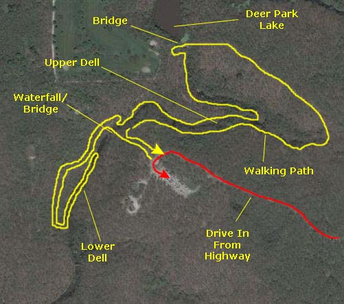
|
To the Lower Dell
|
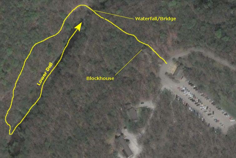
At the end of this long stairway and trail, we came down a final set of stairs onto a bridge across the canyon where the trail to the lower dell continued on the other side. From the bridge, we had a good view down into the lower dell. We crossed to the other side of the bridge, and then headed southwest along the trail to the lower dell.
|
|
The trail paralleled the northwest side of the canyon for about a quarter of a mile, and then turned toward the canyon, descending another long set of stairs. These stairs came out at another bridge across the canyon. I wasn't quite sure why the trail just hadn't gone along the southeast side of the canyon, but perhaps it was too steep on that side to build a convenient trail. In any event, as we crossed that bridge, we got our first look down into the lower dell. We could see the path in the lower dell leading back up the canyon towards the first bridge we'd crossed, and we could see the stairs that would take us down into the dell. So, on the far side of the bridge we descended the staircase to the lower dell.
Hiking in the Lower Dell
|
|
 Click Thumbnails to View |
While we were here in the lower part of the dell near the bridge and stairway, I made a movie of our surroundings, and you can use the player at rightto watch the movie.
As I said, we walked the length of the dell back up to the waterfall at the first bridge we'd crossed. (Since you can't climb up the waterfall, that is where the lower dell ends, and you have to retrace your steps back to the stairway.) The scenery along the way was very shady, very cool and very pleasant. About halfway along the canyon floor, we came upon an extremely interesting carved boulder. It was interesting to speculate that it might have been done centuries ago by some long-forgotten and long-vanished native peoples, but, more likely, it was done more recently. You can see one more picture of Fred with this boulder here. As for the rest of our walk up to the beginning of the dell, I've put thumbnail images for some of the pictures we took along the way below; just click on them to see the full-size pictures:

|

|
After walking through the length of the dell, we arrived at the rock face almost directly underneath the first bridge we crossed. Here, we found a trickling waterfall (presumably a lot more interesting after a heavy rain). We were enclosed in an almost circular area, with a pool below the waterfall. There did not seem to be much of a creek running back down the canyon; I guess that when the water is flowing this little, the ground absorbs most of it. Below are some thumbnails for the best of the pictures we took here, of the waterfall, the bridge above, the canyon and the fence that keeps people from walking over the sheer drop from the upper dell to this lower one. Have a look at these pictures by clicking on the thumbnail images:

|
|
|
Hiking in the Upper Dell
|
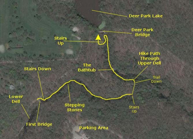
Now the trail led upriver (or upcanyon, if you prefer). From the first bridge, this was the view up the canyon; once we'd gone a short distance, we could look back down the canyon towards that first bridge.
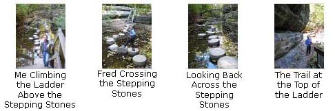
A bit further on, we came to some stepping stones that led us across the stream to a ladder up to the trail on the other side. I went first across the artificial stone pathway so Fred could take a picture of me halfway across.
|
|
 |

|
|
|
The trail continued up the canyon floor for a ways until we came to "the bathtub." At least that's what the sign back at the shortcut had called it. The bathtub consisted of a relatively deep pool (about four feet, I'd guess) fed by a small cascade that came over a semi-circular outcropping of rock. Beside the pool was a stairway for the trail to continue up the canyon; you couldn't easily just climb the rocks over which the water was falling. We took some pictures around the pool and then climbed the stairway to take some more pictures at the top of the little waterfall. Click on the thumbnail images below and you can see the best of these pictures:

|
|
|
From the bathtub, the trail continued up the canyon, hugging the canyon wall sometimes. Finally, the trail came to a large open area with another pool and another cliff face and small waterfall. This was the end of the canyon, and we could see the Deer Park Bridge above us.
We climbed around on these cliff faces for a while, and then ascended the stairs beside the pool to get up to the Deer Park Bridge.
Walking from Deer Park Lake Back to the Car
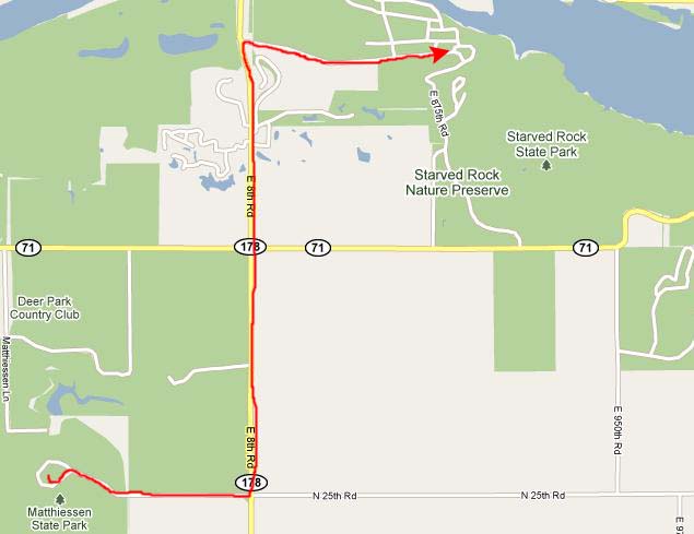
We were back out in the sunlight for a while as we crossed the bridge back to the east, but then we were in forest again as the trail wound through the woods, staying above the canyon on its east side. After about a half mile or so, we arrived back at the first bridge we had crossed earlier, and took the same stairs and trail back to the parking area. Then it was on to Starved Rock State Park.
Starved Rock State Park
|
Starved Rock State Park is the major tourist attraction in north central Illinois. It is very popular; in 2009, a quarter million people went through the visitor center and park attendance exceeded 2 million people.
The waterfalls and canyons of the park are unexpected wonders, nestled within 2,630 acres of lush forests. Many trails criss-cross the park, some up on the bluff and some along the water, but both present spectacular views along the Illinois River.
The backdrop for the park are the 18 canyons formed by glacial meltwater and stream erosion. They slice dramatically through tree-covered, sandstone bluffs for four miles at the park. The park is best known for these fascinating rock formations, primarily St. Peter sandstone, laid down in a huge shallow inland sea more than 425 million years ago and later brought to the surface. While the areas along the river and its tributaries still are predominantly forested, much of the area is a flat, gently rolling plain. The upland prairies were created during an intensive warming period several thousand years after the melting of the glaciers. The Illinois River Valley in the Starved Rock area is a major contrast to the flatland. The valley was formed by a series of floods as glacial meltwater broke through moraines, sending torrents of water surging across the land and deeply eroding the sandstone and other sedimentary rocks.
During early spring, when the end of winter thaw is occurring and rains are frequent, sparkling waterfalls are found at the heads of all 18 canyons, and vertical walls of moss-covered stone create a setting of natural geologic beauty uncommon in Illinois. Some of the longer-lasting waterfalls are found in Wildcat, LaSalle and St. Louis canyons; there was still a small amount of water in some of these now in October. It's unfortunate that we weren't here during the spring, but then the weather for hiking is not so good as in the fall.
You might be interested in an aerial view of the park area, so I've included a labeled one below:
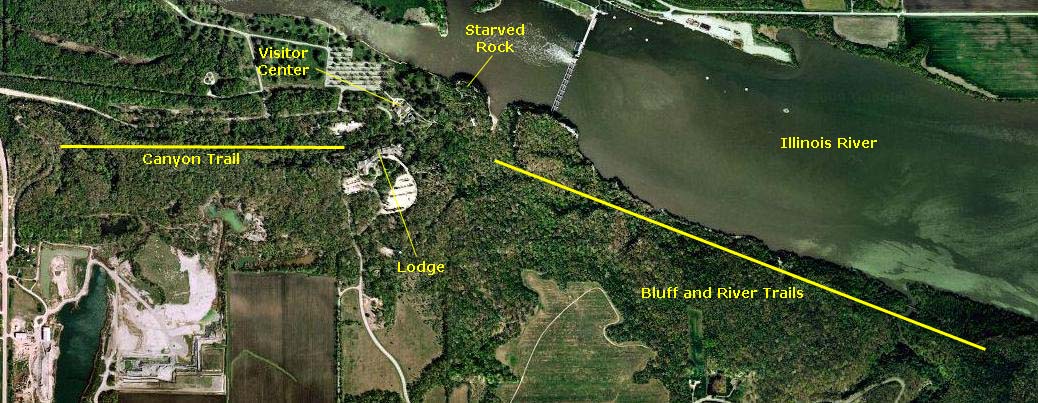
We took a great many pictures during our afternoon of hiking here at Starved Rock State Park. To try to organize them into some semblance of order, we'll take them pretty much in sequence, but we'll break up the afternoon into sections. We'll begin with the area around the Visitor Center and Lodge, including Starved Rock itself. Then, we'll do the canyon trail that extends west from the lodge almost to the highway. Returning to the lodge we'll have lunch. After eating, we'll head southeast along the bluff trail, visiting some of the upper canyons. Then we'll descend to the river to continue southeast to visit the lower canyons. Finally, as we retrace our path northwest along the river, we will eschew returning up along the bluff trail, but continue along the river to visit the overlooks that we bypassed earlier. We did a lot of hiking, and I hope you'll enjoy following along with us.
Visitor Center Area and Starved Rock
|
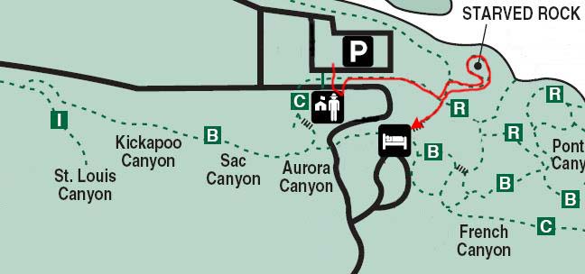
We'd been cautioned in the visitor center to stay on the trails, not so much because the terrain off them was so delicate or anything, but because the area is rife with poison ivy in all its forms. This was good advice; there certainly was a lot of it around. We found the Starved Rock Trail easily enough and pretty soon we were climbing the stairs to the top of the rock.
Archeological investigations of a large part of the top of the rock has disclosed this landmark to have witnessed approximately 5,000 years of continuous human use. All but the Paleo-Indian Period is recorded in this long sequence of repeated occupation. The Rock became famous in 1682 when La Salle constructed Fort St. Louis on top to induce the Illinois Indians to remain in their village (Old Kaskaskia) after they had been scared off by an Iroquois war party in 1680.
In 1760 the English appeared at Starved Rock and started trading with the Native Americans. By 1763 the French had left and the English dominated the countryside. Meanwhile, Pontiac, a great Ottawa chieftain, had gone down to the southern part of Illinois to negotiate trade agreements with the French. During his stay he was murdered by an Illinois of the area. Word got back to his tribe and they wanted to avenge Pontiacs' death. So the Potawatomi and Fox, sub-tribes of the Ottawa people, paddled down river and attacked the Illinois village by Starved Rock. For several days the attack raged on. The Illinois knew that in order to survive they had to leave the area, but instead they decided to seek refuge on top of the rock. They climbed up to the summit of the rock hoping that the Potawatomi and Fox would by-pass them on their way southward. Unfortunately, the plan backfired and the Potawatomi and Fox surrounded the base. They cut off food and water to the Illinois on top of the rock. As the Illinois grew desperate, some tried sneaking down, but they were murdered. The rest that were left on top starved. Since then, the rock has been known as "Starved Rock."

|
Archeologists have recovered a great amount of early 18th century artifacts from the site. When the fort was abandoned in 1691, it remained in use by Native Americans, and artifacts of what is thought to be the Peoria tribe of the Illinois indians have been dated to 1736. The rock's present-day name was not to come into use until sometime after 1769. Several hundred feet east and downslope of the Starved Rock Park Lodge lies the Hotel Plaza Site, occupied repeatedly in ancient times. This encampment was heavily occupied in the 17th and early 18th centuries by Indians concentrated around Starved Rock as a defensive measure. Its rich history was disclosed by excavations in 1948. And across the Illinois River from Starved Rock lies the old Kaskaskia village, or the Zimmerman site. This large village has a 1000-year old history of settlement as a preferred location for farming; most of it is now under the water of the flood pool behind the Starved Rock Lock and Dam. The site is famous for Father Marquette's visit to the Kaskaskia Indians in 1673. The site had 460 cabins before the Iroquois raid of 1680. Later many thousands of Indians were said to have was occupied the site.
Archeology and history agree upon the lifeways of these villagers. They lived in their village during the spring and summer. In early winter and in mid-summer before the corn harvest they roved the upland prairies in search of bison or American buffalo. Although these large game animals were not as plentiful as they were west of the Mississippi, herds were an important source of food. Prehistoric occupants of this village lived in very different housing and pursued a more sedentary existence. Dwellings were earth-covered and set part-way into the ground to resemble the earth lodges of the Plains Indians. Hunters concentrated on game available locally and on plentiful fish.
When we were done at the top of Starved Rock, we descended and walked across a small valley and up the hill to the Lodge. The West Bluff Trail began around on the other side of the Lodge.
The West Bluff Trail
|
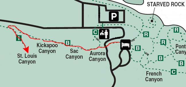
Then the trail rose again and became a boardwalk almost all the way to the junction with the trail down into St. Louis Canyon.
Our little guide told us to watch for the rock column that would mark the beginning of the St. Louis Canyon branch of the West Bluff Trail. So we turned back south and headed down the trail into the canyon. When the trail stopped descending, we crossed the first footbridge over the little stream that comes out of the canyon. A few feet further on, we crossed a second footbridge and headed into the canyon proper.
|
|
Below are four thumbnail images for the best pictures we took of the little waterfall at the head of St. Louis Canyon. Click on them to view the full-size images.
 |
Starved Rock Lodge and Lunch
We got some directions to the dining room and headed off down the long hall to the public areas of the lodge. The hall came out into a great room with tall ceilings and a huge fireplace. The entrance to the Starved Rock Room (the dining room) was at the end of this great open space. For lunch, we both chose the buffet, although I just did the salad part. The food was quite good and we got plenty to eat. The lodge is very nice inside, and it would be fun to stay at one like it sometime. After lunch, we were off to hike the trails to the east and south of the lodge.
Below are some thumbnail images for pictures we took inside Starved Rock Lodge. You can click on them to view the full-size images:

|
The East Bluff Trail
|
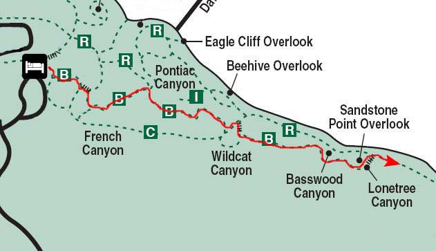
Starting out, we skirted the parking area for the Lodge and campground, and then headed off into the forest down the first of many staircases and boardwalks that we would encounter on the trail. The first canyon we came to was actually off to the side of the Bluff Trail, so we didn't go into it; this was French Canyon. (The ranger had mentioned that at this time of year there was no water at all in that canyon, so we bypassed it.) We followed the trail around by Pontiac Canyon; there was no water here, either.
Then we came to Wildcat Canyon. Here at the top of the canyon, there was a series of boardwalks that led in different directions. It wasn't until we'd explored a bit that we discovered where they led.
|
|
As it turned out, the left hand boardwalk dead-ended at an overlook for Wildcat Canyon.
|
|
The Bluff Trail continued via another boardwalk over to the other side of Wildcat Canyon. You can see a picture of Fred at this second overlook (and a view back to the first one) here. From this overlook, we could not only look downriver at the lock and dam but also across the river at the Kaskaskia site. Fred also took a couple of river pictures here, one of barge traffic and one of the old tourist hotel that is now part of the lock and dam property.
The last part of the Bluff Trail took us by Basswood Canyon and Lonetree Canyon, and then down the long stairway to the River Trail.
The River Trail
|
|
|
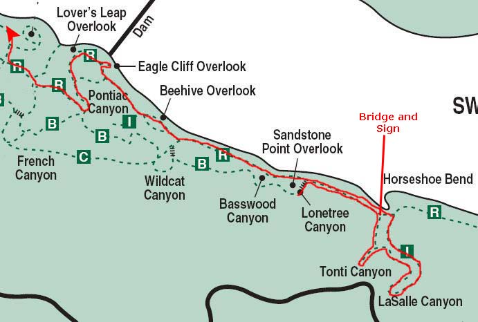
We walked along the trail, heading to Tonti Canyon. Just a little ways down the trail, we found a small canyon that wasn't marked on the trail guide, and we went in to take a look.
|
The Lobby of the Statehouse |
We walked a bit further on along the trail, and then we came to a footbridge over what turned out to be the small stream coming out of LaSalle Canyon. Here, we found that the trail forked; as the sign said, you could go either to LaSalle Canyon first or to Tonti Canyon. The trail was a loop off the main trail along the river. It didn't matter much, but we decided to go visit Tonti Canyon first.
Tonti Canyon wasn't far along the loop trail that we took. There was no water here, but the canyon was interesting for the rock formations and for the fact that you could see evidence that water does flow here at least at some times of the year. I have put some thumbnail images of Tonti Canyon below; click on them to view the full-size images.
 |
|
|
We continued on along the trail past Tonti Canyon heading to LaSalle Canyon. This trail was ascending somewhat along the course of the little stream that was coming from LaSalle Canyon. There were a couple of bridges and some stairways before you came down the last stairway into LaSalle Canyon. Below are some thumbnail images for some of the pictures we took along the trail between Tonti and LaSalle Canyons. Click on them to view the full-size images:

|
When we came down the final set of stairs we had entered LaSalle Canyon. The canyon was the largest we'd been in today. The beautiful rock formations swept around us in almost three-quarters of a circle. In the middle of the canyon wall there was a small waterfall; well, small at this time of year, anyway. It spashed into a small pool, giving rise to the small stream that we'd followed up here from the river. We had the canyon almost to ourselves; it was certainly a beautiful place. I have put six thumbnail images below for the best of the pictures we took here. I hope you'll click on at least some of them to see the beauty of LaSalle Canyon.

|
|
|
LaSalle Canyon was a great place to spend some time, what with the restful sounds of the small waterfall in the background and, of course, the great scenery. But we had to press on, and so we took the trail from the canyon and headed off. Presently, we came back to the trail junction where we'd left the River Trail to head up to Tonti Canyon. However, since we'd gone all the way to LaSalle Canyon and gone under the waterfall that gave rise to the stream we'd been following, when we returned to the junction we were on the other side of the footbridge we had seen earlier.
We gave some thought to continuing on along the River Trail, but since the ranger had given us to understand that the most interesting canyons were from LaSalle westward, we decided to head on back towards the visitor center. This time, however, we stayed on the River Trail instead of going back up onto the bluff. This meant we had nice views of the Illinois River all the way along, and we could see the wildlife in the river as well. We did pass some other small canyons, and I went in one of them to climb around for a few minutes. We also stopped at the small Beehive Overlook, where what you saw mostly were downriver views.
Our next stop was the Eagle Cliff Overlook. It is named for the bald eagles that roost in the large trees at Starved Rock during the winter, on the islands downstream from the dam. Fish, their primary food, are available where the burbulence below the dam keeps the water from freezing. The overlook consisted of a series of balconies and walkways built right on top of a bluff at the very edge of the river, and so the views were tremendous. If you'll click on the thumbnail images below, you can see some of the pictures we took on and from the Eagle Cliff Overlook.

|
The Kaskaskia, a tribe of Illinois Indians, lived directly across the river from Eagle Cliff Overlook. At the time of European contact in 1673, their "Grand Village" had 74 lodges and about 735 inhabitants. Other local tribes banded together with the Kaskaskia to take advantage of trading opportunities with Europeans living in Fort St. Louis, located on top of Starved Rock. this combined population of Illinois, Miami and Shawnee Indians reached nearly 9,000 and provided safety in numbers from the raiding Iroquois. when their trading and land rights were threatened, the Kaskaskia were forced to move. By 1764, their population had dwindled to 600 and was declining rapidly. Survivors of the once-numerous Illinois Nation were moved to Kansas in 1832.
|
The Lobby of the Statehouse |
Our final stop this afternoon on the River Trail was the Lover's Leap Overlook, which was just opposite to a little downstream of the lock and dam. The Starved Rock Lock and Dam is part of a "water stairway" that connects Lake Michigan to the Mississippi River. In 1933, the U.S. Army Corps of Engineers completed a system of seven locks, called the Illinois Waterway, to make the shallow Illinois River usable for commerce. Before the Illinois Waterway, boats moved through the narrow I&M Canal located to the north of the river. Its locks could only hold a single barge or boat at one time. Today's locks are capable of handling eight barges and a towboat. More than 45 million tons of coal, gravel, silica, soybeans, grain, fertilizers, petroleum, iron products and chemicals are locked through here each year. The Illinois Waterway Visitor Center across the river has displays about lock and dam operations and the area's history. From the observation deck, you can view the working lock.
|
Paddling upriver in birchbark canoes, French voyageurs led by Father Jacques Marquette (a famous name in Michigan and Illinois, as in Pere Marquette, Michigan, for example) and Louis Jolliet (the town of Joliet, Illinois) arrived here in 1673. they were looking for Native Americans to trade with and convert to Christianity and for sites to build French forts.
Robert LaSalle (LaSalle Canyon here, LaSalle Street in Chicago, etc.) and Lieutenant Henri de Tonti (Tonti Canyon here) came to this area in 1679. Near Starved Rock, they built Fort St. Louis, which served as headquarters for a fur-trading post. This fort pre-dated the city of St. Louis; the city of St. Louis was not actually founded until 1764, when Auguste Chouteau arrived at the site he'd picked out a year earlier and began construction. No evidence of the fort remains, but over in Matthiessen State Park we saw a replica of what the fort might have looked like.
Well, we've done about all we can here at Starved Rock State Park today. Fred was the one who found out about it and plumped for stopping here, and he turned out to be right on the money. It has been a very enjoyable day. When we left Lover's Leap Overlook, the boardwalk continued to a junction. If you will watch the movie below, I'll explain it.
|
|
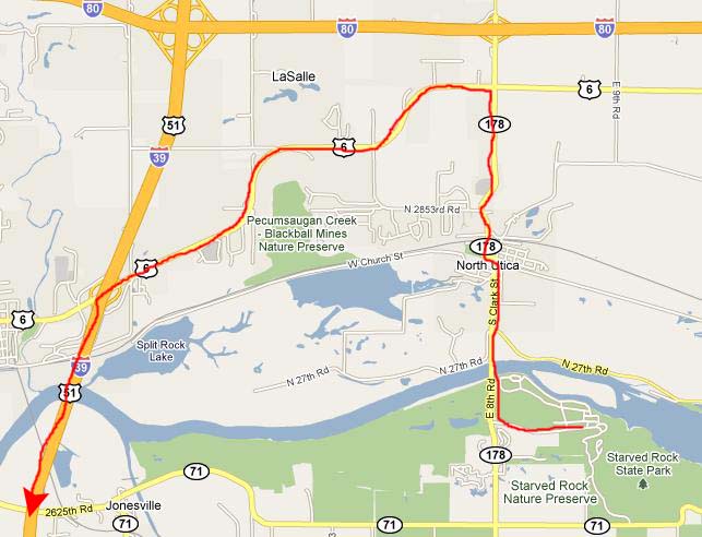
It was about a five-minute walk through the beautiful forest and along the boardwalk (you can see Fred on the boardwalk here) to the Visitor Center. Once there (and it was closed by the time we returned), we just went back to the car and had a soda, hooked up the GPS, entered Fred's address and headed off for home.
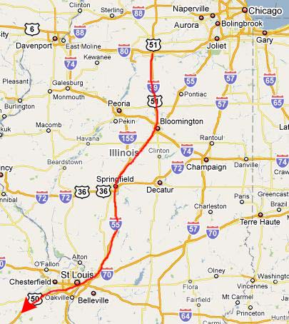
The Drive Home
|
North of town, we took a shortcut on Highway 6 over to Interstate 39 south.
|
|
|
We'd had a big lunch at the buffet in Starved Rock State Park, so we weren't in any hurry to stop for dinner. Just past St. Louis it started to rain heavily; driving became a chore rather than a pleasure. We pulled into a Super 8 in Lebanon, Missouri for the night, having a late supper at a little restaurant across the street.
On Thursday morning, the weather was about the same as we continued our drive back to Van Alstyne through Missouri, Oklahoma and North Texas. We arrived back at Fred's house in mid-afternoon. It was a great trip, but we were both anxious to get home.
You can use the links below to continue to the album page for different day.
 |
October 5, 2009: Our Drive from Green Bay to Southern Illinois |
 |
Return to the Index for Our Midwest Trip |