


 |
July 22-24, 2005: A Trip to Visit Ron and Prudence |
 |
July 4, 2005: 4th of July Party at Ron and Jay's |
 |
Return to Index for 2005 |
July 14, 2005: A Bike Ride Along the Beach
Well, it is July now, and the condo renovation has been going on for about three months. Things would be further along were it not for the snafu that we had with the permit process a month or so ago. But things are moving along nicely now, and this week, we should be getting a lot of the tile installed.
 |
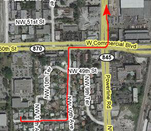 |
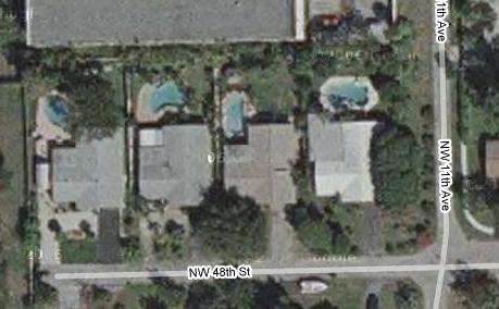
There are lots of ways I could go, but I like to take advantage of bike lanes or less-traveled streets wherever possible. Commercial Avenue would be a straight shot over to the beach, and getting up to Commercial Blvd. from Ron's house is easy, and just a few blocks on neighborhood streets. But Commercial does not have a bike lane, is undergoing road work and is very, very busy. So I'm in the habit of going up to Atlantic Boulevard (about two miles north) instead. To get there, I head up Powerline Road. Even though Powerline does not have a continuous bike lane, it is either three lanes wide, or has short stretches of bike lane or has good sidewalks. In addition, it is much less busy than Commercial.
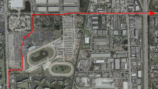 |
Cutting through the parking lots lets me out the north entrance onto Pompano Park Road, which is actually SW 3rd Street in Pompano, the next city north from Fort Lauderdale. This is a wide, mostly divided street. Although it doesn't have a bike lane, it is sparsely traveled and it does have a bridge over I‑95. Heading east I am paralleling Atlantic Blvd. a couple of blocks north, but Atlantic is also a busy street and the bike lane doesn't start until you get to the east side of I-95.
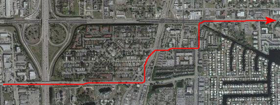 |
Although Atlantic is one of the major east-west streets here in Pompano and is for that reason heavily traveled, the bike lane makes it an easy, reasonably safe ride.
 |
Here, I can turn north towards Hillsboro Inlet or south towards Fort Lauderdale and follow the familiar route that I've taken biking along the ocean so many times before. Today, I don't have a great deal of time, so I'm going to turn south first and head down to Las Olas, then turn around and come back north, and then take some side streets alongside Commercial Avenue back out to Ron's house.
Today, I just want some exercise, and won't be taking a lot of pictures. There are a lot of interesting things along the oceanfront, both south to Las Olas and way north of here to Palm Beach, but I won't describe them on this page. If you have access to the photo album for 2006, you can access the page for my trip to Florida June 1-9. On that page you will find a complete description of my 100-mile bike ride, which covers the entire distance from my condo to the north side of Palm Beach, Florida. Today, I am covering the distance between Las Olas in Fort Lauderdale to Atlantic Boulevard in Pompano Beach.
|
|
I did take some pictures at the condo today to record the progress of the restoration. If you would like to see today's pictures, just click on the link below. At the end of those pictures there will be a link that will bring you right back here to this album page.
July 15, 2005: A Bike Ride Along the Beach
This afternoon, I decided to take another bike ride since the weather was so nice. I took the same route to the beach that I normally do, went south to Las Olas and then back north and back to Ron's house.
There weren't too many people out this afternoon; it had been a little rainy earlier in the day and in any case it was late in the afternoon. I did try my hand at taking two movies while I was on my bike and heading north, and you can watch those movies using the two movie players below. I also took one picture when I stopped for a while at Sebastian Street Beach.
|
|
July 16, 2005: An Intracoastal/New River Boat Ride
Today will be a welcome change from riding my bike. Ty and Scott have invited me to join them on a boat ride with their friends Dick and Preston. Dick lives right on Las Olas down by the Las Olas bridge over the Intracoastal, and he has a 40-foot boat that he keeps behind his house on one of the canals in this area of the finger islands.
After taking some pictures at the condo, I went back out to Ron's house to change, stopped at the grocery store to get some supplies as my contribution to the trip, and then drove back down to Dick's house on Las Olas.
Preparing for Our Cruise
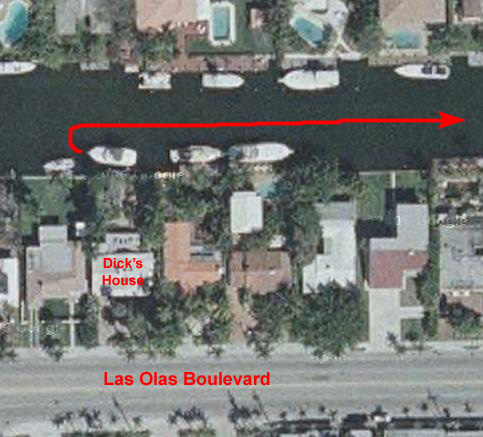 |
You might think that the aerial view can't possibly be so accurate that I could point out the exact boat we were on, but in fact it is. Perhaps the residents here don't change boats very often but, nevertheless, you can see, in this picture of the canal looking towards the Intracoastal, the stern of the exact same boat that you can see in the aerial view. You can even see the very top of the boat in front of it- the view is that accurate. If you have any doubts, all you have to do is compare the docks and how they are arranged or orient yourself.
An Overview of the Boat Trip
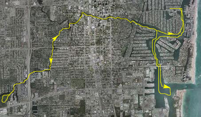 |
Generally, then, Dick turned the boat around and headed east down his canal to the Intracoastal Waterway. Then he turned south and followed the waterway first south, past Bahia Mar, then west around some of the exclusive residential islands, and then south again. Eventually, we passed underneath the Seventeenth Street Bridge and into the Everglades Basin. This is the deep-water port access for Fort Lauderdale, and it is the basin where which the cruise ships dock. They have deep-water access to the ocean through the Everglades Inlet.
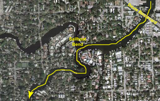
We did a large circle in the Basin, and then headed back north and underneath the Seventeenth Street Bridge again. We continued north to the mouth of the New River, and then headed west, upriver. The water access is quite wide for a ways, and then the river narrows considerably as it begins to wind its way into and through downtown Fort Lauderdale. It passes my own condo, of course, and goes over US-1 and underneath Andrews Avenue and 3rd Avenue. Then it reaches River Bend where the Performing Arts Center is and turns southwest. It passes through an area known as Sailboat Bend, then continues southwest and then south, passing under Davie Boulevard.
Then, the New River reaches an area where some of the major boat refitting docks are. This area is the reason why there are so many large boats that go up and down the river past my condo at all times of the year. At the boatyards, the New River turns west and eventually goes under Interstate 95. It winds its way a bit further, eventually reaching the last basin- Marina Bay. This is a new area that has been built up only in the last ten or fifteen years. Here, we did another turnaround and then headed back the way we had come, all the way down the New River back to the Intracoastal Waterway.
When we reached it, we continued east and then north, back under the Las Olas Bridge and, just north of the bridge, turned into Dick's canal to bring the boat back to dock behind his house. The whole trip took about four hours and was extremely enjoyable. Let's take a look at the trip in more detail, and look at the pictures and movies I took along the way.
Everglades Basin and Harbor
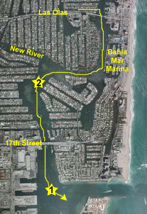 |
After a short ways, we pass the Bahia Mar Boat Basin. There are a lot of very large boats here- the ones with helicopters on top- and the dock for the Jungle Queen Riverboat is also here.
Passing the Marina, we have huge homes on both sides of the Intracoastal- built on artificial islands and peninsulas.
We have to turn west for a ways and then we can head south again towards the 17th Street Bridge. I made a movie as we did so, and you can watch it with the left-hand player, below. Using the right-hand player, you can watch us pass under the 17th Street Bridge to arrive in the Everglades Basin.
|
|
Below are some pictures that we took while we were in the ship basin (#1 on the aerial view above) (you can see Scott and the one cruise ship that hasn't yet left) and after we turned to head back north and under the 17th Street Bridge again. To view a full-size image, just click on its thumbnail:
|
After we got back under the 17th Street Bridge heading north, we headed further up the waterway to the mouth of the New River. On the way, we could get some good views of the many impressive waterfront homes that line the artificial islands and peninsulas all along the Intracoastal. To view a full-size image, just click on its thumbnail:
|
The New River to Riverview Gardens
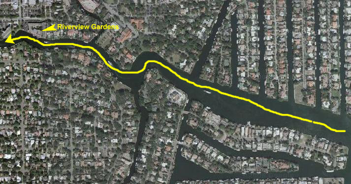 |
It is for that reason that many of the major boat companies have some of their construction and refitting dock areas up the river on the west side of the city. The river is kept dredged as needed to allow the river to be navigable for even very large boats. Of course, there are a plethora of smaller pleasure craft like the one we were on going up and down the waterway all the time.
As we turned into the river from the Intracoastal Waterway, you can get a nice view of the mouth of the New River with downtown Fort Lauderdale ahead of us and the finger islands and peninsulas on either side of us. This is one of the premier places for people to live in Fort Lauderdale, and the homes are extremely nice. This home, for example, occupies a prime site at the very end of one of the artificial finger islands that can be accessed off of Las Olas Boulevard. Years ago, I happened to be jogging down one of these islands and came across a vacant lot at the end of one of them- much like the lot this house is on. Out of curiosity, I called to find out the price; the empty lot was for sale for $1.8 million- so you can imagine what the lot AND house would cost!
|
|
For now, have a look at the movie of us passing Riverview Gardens on our way up river and into downtown Fort Lauderdale. Use the movie player at left to do so.
Boating Through Downtown Fort Lauderdale
 |
|
|
As you are passing the Las Olas Grand and the Water Garden, there is another new high-rise on the south side of the river (one of the few that has been built on that side of the channel) called NuRiver Landing. Although it is not the tallest of the new condominiums, it may well be the one with the most units as there are, I think, twelve or fourteen of them on each floor. On the upper floors are larger penthouses and the swimming pool. It looks like a very nice building, and they, too, have built a series of fountains on the river side of the building where the main entry is, and these fountains are certainly the most extensive of any of the new high-rises. The only drawback to this particular building is that it is on the south side of the river, but that should not be a problem for long, as most new development from this point forward is going to have to take place there, as the last of the building sites on the downtown side of the river is currently being developed.
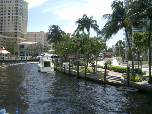 |
Unlike San Antonio, the Riverwalk is not sunken below street level and, also unlike San Antonio, it is built along an actual waterway, and not an artificial canal. Because of that, as you walk along, there are always boats docked along the river, as well as river traffic going up and down for the pedestrian to look at. Most of the dinner cruise boats have their docks along the Riverwalk (all except the Jungle Queen, as it is way too big), and people are always lining up for the lunch, afternoon and dinner cruises down the river to the Intracoastal Waterway. But the vast majority of the boats are private craft- some of them quite large- and of all different types.
Of course, Fred and I (and everyone else who's visited down here) have walked along the Riverwalk many times; it is one of the most interesting things to do downtown. And for years, we've seen the same boats docked in the same places (there is a lot of competition for the few available spaces, and once someone gets one, they don't usually give it up). So if you look at the earlier aerial view of this portion of the trip, it would not be unusual if you could pick out some of the same boats that you see in these pictures and movies in that aerial view. I can see a few of them myself.
The first of the downtown bridges that we pass under is the 3rd Avenue Bridge. 3rd Avenue is one of the major north-south streets through downtown; it parallels Federal Highway about four blocks west. The NuRiver Landing is just on the south side of this bridge, and the Las Olas Grand and the Water Garden are just before this bridge on the north side. I've marked this street on the aerial view above. These bridges downtown are drawbridges that have to be raised to allow many larger boats, and all sailboats, to pass under. They open on demand except at rush hour, when their opening and closing would tie up traffic too badly, so boat owners have to be aware that they won't be able to proceed up and down river at those times.
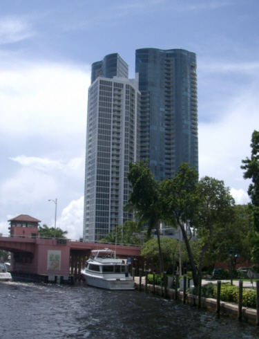 |
Just past the River House is the Andrews Avenue Bridge, and just beyond that is the Riverfront entertainment complex. I have pictures of both of them elsewhere in this album. Next, we passed Old Fort Lauderdale on the right and Shirttail Charlie's on the left and arrived at River Bend. Here, the river makes a turn to the south right in front of the Broward Performing Arts Center. You can see the gardens in front of it and the Riverwalk circling along the bend in the river in front of them. The Science Museum is off to the right, out of the picture, as are some fountains and a broad part of the Riverwalk.
Just next to the Performing Arts Center, around the bend in the river, is the newest of the downtown high-rise condominiums, the Symphony- aptly named for its location next to the Performing Arts Center. These are handsome buildings, and I like them both for their balconies and for the fact that they are rectangular, which makes decorating much easier than in places like River House, with its curved walls. This is also a large complex, with lots of amenities. Each of these buildings I have pointed out has its own website, and if you are interested in seeing what the units might look like, you can investigate any of them. The Riverwalk goes in front of the Performing Arts Center and then ends here at the Symphony. The Symphony is also a good place for people who have boats to live, as the complex has its own marina.
Just across the river (east of the Symphony, since the river has turned to head south) is one of the older condominiums in town- the aptly-named River Bend Condominium. It's an octagonal building, also with nice balconies and, from the upper floors, great views in all different directions. There are no high-rises right around it (except the Symphony) to block its views, and we are at the western edge of downtown, so the views should last quite a while.
Sailboat Bend
 |
|
|
The Boatyards and I-95
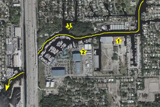 |
I marked one of the boat facilities on the aerial view (#2) because it was so unusual. It consisted of two high, domed "boatports" where you could pull the boat entirely out of the water and work on it without being exposed to the elements. I guess this extends the effectiveness of the repair schedule- particularly during the rainy seasons here. They were kind of neat.
|
|
A little further on, we passed a wooded area on our right (#3), and there were a whole bunch of kids playing with a rope swing and from all indications having a really great time. Pretty quickly, we could see the interstate highway ahead of us past the boatyards, and soon we were heading under it. Here are a couple of pictures taken as we passed under the bridge. Just click on their thumbnails to view the full-size images:
|
Marina Bay
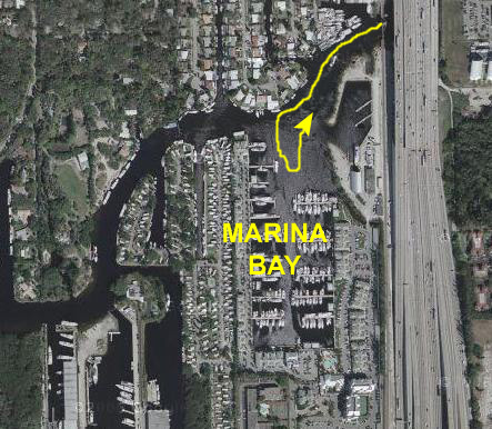 |
My movie of Marina Bay, that you can watch with the player below, will give you an idea of what it is like.
|
|
|
|
We tooled around in the bay for just a while, and then turned for our return trip down the New River. We had to wait a while, however, because the train bridge just beside the highway was down to allow a commuter train to cross (watch it with the movie player at left) heading south towards Hollywood and Miami.
|
|
|
|
The Trip Back Down the New River
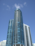
I've pretty much already shown you the route along the New River; we are simply retracing that route to get back down to the Intracoastal Waterway. On the way down the river, I was able to get some pictures and movies that I didn't have a chance to capture on the way upriver, and I also got some different views of buildings, bridges and the New River that you might want to see. To see any of the full-sized images, just click on the annotated thumbnails below:
 |
 |
|
|
|
|
 |
 |
 |
|
|
|
|
 |
 |
 |
|
|
|
|
 |
 |
 |
 |
|
|
 |
Returning to Dick's House and Docking
|
|
I was very appreciative of Dick's allowing me to join them on the cruise and, now that I have finished this portion of the album, I can make a CD of the trip and see that Ty gets a copy of it to Dick.
I took some pictures at the condo today to record the progress of the restoration. If you would like to see today's pictures, just click on the link below. At the end of those pictures there will be a link that will bring you right back here to this album page.
July 18, 2005: A Bike Ride to Deerfield Beach
After I checked on the tile work at the condo, I went back out to Ron and Leroy's house for the rest of the day. It was only early in the afternoon, so I decided to go bike riding- this time heading north from Pompano Beach. Following the route described on this same album page above, I biked from Ron's house over to the point in Pompano Beach where Atlantic Avenue deadends into Briny Avenue- the beachfront street in Pompano Beach. Then, I headed north. I did take a few pictures along the route today, and I'll comment on them below. If you'd like to know about the route I took, and you have access to the album pages for 2006, you can navigate to that year and the trip for June 1-9, where I have a detailed description of the route. Today's portion will be Atlantic Avenue in Pompano Beach to Deerfield beach and back.
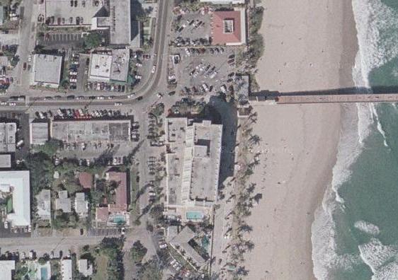
On my bike ride today, I covered a lot of familiar ground, and I guess some of these pictures get repetitive. Here at Hillsboro Inlet, for example, not much changes from year to year. This view looks out to the Atlantic from the top of the bridge over the inlet; being a weekday, there wasn't any boat traffic to speak of. And the inlet itself doesn't change at all, of course. But on the Intracoastal side of the bridge, to the north, there is a new condominium building that has been built right at the south end of what is actually Hillsboro Beach- a different city than Pompano Beach on the south side of the bridge. Because of where it is, I expect that the units in the building are much more expensive than comparable ones in buildings just across the bridge to the south. Beginning here, as I bike north, the seaside homes are pretty palatial.
|
|
 |
|
|
This is where my bike trip will end today, but before I head back, take a look at this movie of the "new" Deerfield Beach using the player at right.
I took some pictures at the condo today to record the progress of the restoration. If you would like to see today's pictures, just click on the link below. At the end of those pictures there will be a link that will bring you right back here to this album page.
July 19, 2005: A Bike Ride to Boca Raton
There wasn't much going on at the condo today, so I took yet another bike ride. You might be curious, but the reason that I do so much bike riding is three-fold. First, I need the exercise, and bike riding is a great way to get it. My recumbent bike is in the condo, covered up with plastic in a room full of stuff, and so using it isn't practical. I don't run much anymore, so biking is my exercise of choice. Second, the scenery is always nice to see, and I don't get tired of seeing the same scenery over and over. At this point, I can visualize the entire bike route from my condo all the way to Highland Beach, mile by mile and turn by turn, in my head. But that doesn't make it less fun. Third, it always feels good when I finally get home, either to my condo or to Ron's house, and can relax in the pool or with a frozen drink. I always feel a sense of accomplishment.
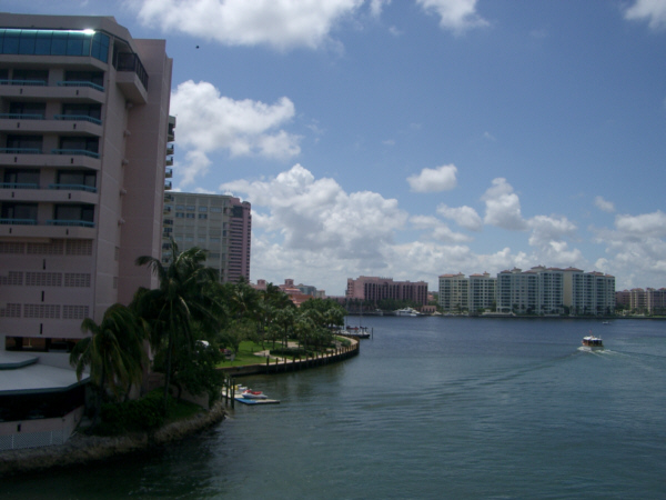 |
I followed the same route as yesterday from Ron's house to the beach, then north across Hillsboro Inlet, up through Hillsboro and Hillsboro Beach and then to the "S" curve in the middle of Deerfield Beach where the pier is. Then the route takes me a bit further north along A1A where I leave Broward County and enter Palm Beach County and Boca Raton simultaneously. Then it is a pleasant stretch along A1A and a very good bike lane to get to the bridge over Boca Raton Inlet. This particular view looks north up and over the bridge towards the beachside condos in Boca Raton. This is as far as I want to come today, although if you've linked to or already viewed the page describing the 100-mile bike ride I took in 2006 you may have already know about the route north from here.
|
|
July 20, 2005: Heading Home
Well, today's the day I am heading home to Dallas. I spent some time at the beach this morning, returned to Ron's house and got cleaned up, and now have stopped by the condo to record the status of the project to date. If you want to see the pictures I took today, just click on the link below. At the end of those pictures there will be a link that will bring you back to this album page.
You can use the links below to continue to another photo album page.
 |
July 22-24, 2005: A Trip to Visit Ron and Prudence |
 |
July 4, 2005: 4th of July Party at Ron and Jay's |
 |
Return to Index for 2005 |