|
September 1-3, 1973: A Weekend in Traverse City, MI |
|
April 13-15, 1973: A Weekend in Muskegon |
|
Return to Index for 1973 |
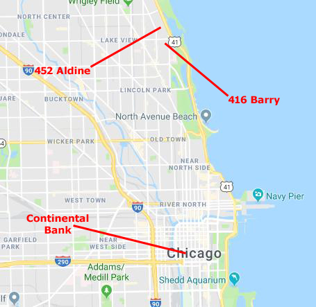
When I first moved to Chicago in 1971, the people at the Bank who hired me pointed me to an area on the north side of the city about four miles from downtown and only blocks from the lake as being an affordable place to live. So when I came to the city on my first familiarization trip, I looked around that area and found an affordable apartment.
|
I found my first apartment on Barry Street, two blocks south of Belmont Avenue (a major east-west street) which is at 3200 North. In Chicago, the numbering system starts at State and Madison, two blocks north and two blocks east of the main Bank building. The numbers in Chicago were planned so that there would be 800 numbers per mile. So, if Belmont is at 3200 North, that means that it is 4 miles north of the 0-0 grid point.
Now, on the map at left, you can see that the lake shore angles northwest, and if you were to walk due north from the 0-0 point you would eventually find yourself walking into the water of Lake Michigan. So, while downtown there might be some addresses that are on East Madison, by the time you get to North Avenue (1600 North), or Fullerton Avenue (2400 North), there aren't any addresses on East North Avenue or East Fullerton Avenue. In fact, even though my first apartment was in the second block of Barry Street in from the lake, that first block was already 400 west (a half mile west of State Street which, of course, doesn't extend past Lincoln Park).
One thing I learned quickly was that the Chicago street system is basically a grid, but that, particularly on the north side where the lake shore is angling northwest, there are some streets that run on the diagonal, but only five or six of them, so that you quickly know their names. When somebody tells you where they live, they tend to use these diagonals as markers, so someone might say "I live at 1815 West Belmont, just a half block west of Halsted (one of these diagonals). (Odd numbers are on the south side of east-west streets or the east side of north-south streets. So if you are driving west on Belmont, you just cross Halsted and look on your left. Getting around Chicago was very easy after just a couple of weeks.
|
The second kind of apartment is the brownstone (brick) building, most of which were built between the two world wars (although some of them are a good deal older. Many of these brownstones were originally either the houses of the wealthy or very upscale apartments rented by the next tier down. As many of these very wealthy people moved out to the suburbs or into some of the more opulent highrise condominiums, the neighborhoods changed with an influx of middle-class working folks- like me. The apartments that might formerly have been ten-room affairs were carved up into one- and two-bedroom units (or, in some of the older, larger buildings, larger units). These were rented to folks looking for "character" in their apartments, as the developers took care to retain as many of the older, classic features as they could as they upgraded kitchens, baths, electric, and plumbing. These conversions tended to be a good deal cheaper but still not for entry-level, middle-class workers (like me).
Since the war, many of these older buildings were simply torn down, and these new, "four-plus-one" buildings put up instead. The name comes from the fact that there were typically four floors of apartments above a ground floor where the building entry, mail room, laundry, and manager's apartment were located. Underneath (and behind, if there was room) were parking spaces (although almost always a good deal fewer than the number of apartments, as many, many city dwellers do without cars because public transit is so good).
|
I could have gotten rid of my car, I suppose. To get to work, I took a CTA bus that stopped at the corner of Sheridan and Barry- less than half a block away (a thirty-minute trip downtown). But I liked the independence that the car gave me. It allowed me to get out of the city whenever I wanted, and also to drive to suburban stores and stuff. It was already paid for, so all it cost me was the $25 a month for parking it under my building.
Had I known that forty years later I would be working on an online photo album that would become more of a life story in pictures, I would have taken lots of pictures in the apartment to record it for posterity (as I have done more recently for other places I have visited). But I didn't, so the brief description- galley kitchen, normal small bathroom, living/dining area and one bedroom- will have to do. One reason I chose this apartment was that it was available. In Chicago, there seems to be a tradition that leases are written for one year beginning either on May 1 or October 1. I started work at Continental Bank on Tuesday, May 30th, of last year (Memorial Day having been on Monday), so I didn't actually move to Chicago until Saturday the 27th. The landlord wrote a least with some pro-rated days that would end on April 30th of this year, at which time I could renew for a year.
In early April, I happened to be out walking around the area. I got as far south as Diversey Harbor (maybe a mile southeast) and Aldine Street (just four blocks north). I took a couple of pictures that day:
|
|
I decided to walk down Aldine just to see if it was different from Barry, and happened to pass a building that looked like mine but newer, and it was advertising apartments available. The starting price was a bit lower than I was paying, so I went in and the manager showed me one of the available units. I liked it. It was a bit larger and a bit newer, and, even though it was also at the back of the building, the view was a little better. Parking was the same. I decided then and there that I would make a change and on April 30th move four blocks north. By this time, I had some friends to help me move. It wasn't difficult, as the company I was renting furniture from agreed to move the big pieces I was renting from them in exchange for another six-month contract. I completed the move on the 29th of April.
|
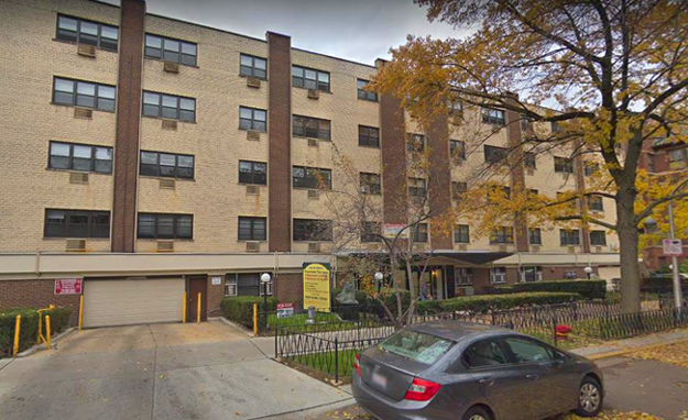 |
Just like on Barry, the Aldine apartment was on the north side of the street, and again the bus stop for downtown was just a few doors east at Aldine and Sheridan. The apartment was a little different, but not all that much, but there seemed to be a little more going on in the neighborhood, even for being only four or five blocks away from my first apartment. This week, even though I haven't got everything put away, I did take some pictures around the building and the apartment:
|
|
|
|
|
|
Those are all the pictures I have of the apartment, but today I also went out for a walk around this new neighborhood, just to see what I could see. As it turned out, I walked a long way, ending up at North Avenue Beach about two miles southeast along the lake shore.
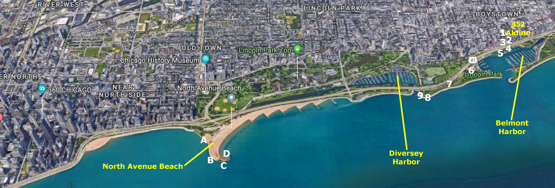 |
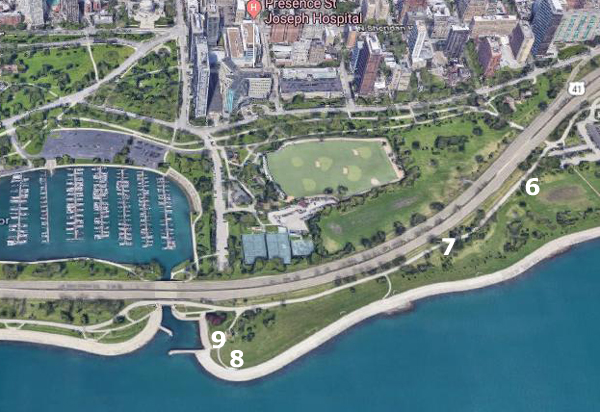
Above is an aerial view of the Chicago Lakefront; it extends from my new neighborhood near Belmont Harbor at the right, and the Michigan Avenue area at the left. To make it fit better on the page, I have rotated it so that north is to the right rather than to the top. I have marked the approximate locations where today's 13 different pictures were taken.
|
|
So I first walked towards the lake and down to the corner of Aldine and Sheridan Road.
|
|
After I crossed under Lake Shore Drive, I was in Lincoln Park. There are places where the park is very thin (and where I am standing it is at its thinnest, basically just as wide as the sidewalk and jogging trail. Belmont harbor occupies most of the space at this point. But north and south of here, the park is much wider, as you can see in the first aerial view above.
|
|
From Belmont Harbor, I walked south along the walkway and the park widened out. Walkers and bicyclists share the paved walkway, and there is also a dirt jogging/equestrian trail in most places.
|
As you can see, just south of Belmont Harbor, the space given over to the harbor is now greenspace, and it is wide enough here to accommodate athletic fields, numerous walkways, and the Diversey Harbor Yacht Club.
Note also how nice it would be to live in one of the highrises that border the park; all you have to do is walk out your frot door and across the street and you are in a park large enough to make you forget you are in the middle of one of America's largest cities. This would be the same feeling people living on either side of Central Park in New York City have.
Lake Shore Drive, which runs from Hollywood Boulevard at 6000 north all the way through and past downtown and south to the University of Chicago at about 5000 south, is the main arterial road along the lake shore. It is an expressway and carries a huge amount of traffic. But as it goes through Lincoln Park, there are tunnels and overpasses so pedestrians, joggers, bicyclists, and equestrians never have to cross it. It's one of Chicago's planning marvels, and I'll have more to say about it on later album pages.
I took a couple of pictures of the greenspace as I walked south, and when I came to the inlet for Diversey Harbor, I got my first unobstructed views of the part of downtown Chicago that runs along Michigan Avenue. Here one finds Chicago's second-tallest building- the John Hancock Center.
|
|
As I said, and as you can see in the aerial view above, you can get on the north side of the Diversey Harbor inlet and look directly south, or at the inlet and harbor. It's not cheap to rent a dock space in the harbor, but lots of people do- and some of them live way out in the suburbs.
|
|
In the picture of Chicago above, left, you'll see a tall building to the right of the Sears Tower. The Sears Tower is over a hundred stories, but that building to the right, an apartment building named Eugenie Square, is "only" 42 stories, but it is much closer- about a mile from where I am standing and two miles closer than the Sears Tower. Little did I know now, but in six months or so I will be moving into Eugenie Square.
|
In the aerial view at left, you can see the south end of the park (and I've also marked the location of Eugenie Square). You can see Lake Shore Drive coming down from the north (remember, north is at right in the aerial view). When the park ends, an area known as The Gold Coast begins; it refers mostly to the continuous row of highrises that line the shore- with only Lake Shore Drive between them and the water. The area got its name because residences in those buildings (which are all condominiums) and on the streets directly behind them, are the most expensive in the city.
I want to caution you again that all these aerial views have been from around 2015-2019, and many of the highrises at the left were built after 1973, so don't try to match my pictures taken today with similar ones taken recently. I can tell you, though, the the buildings along the Gold Coast haven't changed much at all.
|
|
There's one interesting thing I want to point out in the picture of downtown, above left. Just this side of the Hancock Building is a building that houses the offices of an iconic American magazine, and the chain of "clubs" that it spawned. If you can't read the sign, just click here.
|
(seen from the North Avenue jetty) |
This turned into a really nice afternoon walk, but now I needed to head home to my new apartment, which I reached just as it was getting dark.
You can use the links below to continue to another photo album page.
|
September 1-3, 1973: A Weekend in Traverse City, MI |
|
April 13-15, 1973: A Weekend in Muskegon |
|
Return to Index for 1973 |